
- Dataset Availability
- 2018-11-11T00:00:00Z–2018-11-12T00:00:00Z
- Dataset Producer
- IAHS
- Tags
Description
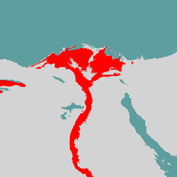
The GFPLAIN250m includes raster data of Earth's floodplains identified using a geomorphic approach presented in Nardi et al. (2006, 2018). The 250m floodplain dataset is derived by processing the NASA SRTM Digital Elevation model gathered from http://srtm.csi.cgiar.org/ , and in particular the 250-m SRTM version 4.1 DTM. The coding used for each continent and additional information are detailed in the metadata included in the GFPLAIN250m data repository.
The elevation data are processed by a fast geospatial tool for floodplain mapping available for download at https://github.com/fnardi/GFPLAIN . The tool first preprocesses DEM to derive hydrologic features (filled DEM, flow direction, flow accumulation, stream network), then computes floodplain extents.
This dataset is applicable in regions where water-driven erosion and depositional processes govern the morphology of floodplain landscape features, and excludes deserts with low water availability and ice-covered regions with insignificant river flows. It is fit for river basins with a contributing area greater than 1000 km2. The GFPLAIN250m dataset can be used in combination with global datasets of human settlements to support large-scale studies of human-flood interactions, human pressure on rivers, and changes over time of floodplain and wetland habitats at risk.
Bands
Bands
Pixel size: 250 meters (all bands)
| Name | Pixel Size | Description |
|---|---|---|
flood
|
250 meters | Flood plain |
Terms of Use
Terms of Use
This dataset is licensed under a Creative Commons Attribution 4.0 International License.
Citations
-
Nardi, F. et al. GFPLAIN250m, a global high-resolution dataset of Earth's floodplains. Sci. Data. 6:180309 doi: 10.1038/sdata.2018.309 (2019). https://doi.org/10.6084/m9.figshare.6665165.v1 ,
DOIs
Explore with Earth Engine
Code Editor (JavaScript)
 var

 dataset

 =

 ee
 .
 Image
 (
 'IAHS/GFPLAIN250/v0'
 );
 Map
 .
 setCenter
 (
 31.25
 ,

 30.05
 ,

 7
 );
 Map
 .
 addLayer
 (
 dataset
 );