
Page Summary
-
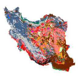
The Iran Land Cover Map v1 dataset provides a 13-class land cover map of Iran for the year 2017, generated using Sentinel imagery processed within Google Earth Engine.
-
This dataset, developed by K.N. Toosi University of Technology LiDAR Lab, utilized over 2,500 Sentinel-1 and 11,000 Sentinel-2 images.
-
The classification was performed using an object-based Random Forest method trained with a large number of reference samples.
-
The dataset includes a single band, 'classification', with a 10-meter pixel size, and a class table defining the 13 land cover types.
-
The dataset is available from 2017-01-01 to 2018-01-01 and is licensed under the Creative Commons Attribution 4.0 International License (CC BY 4.0).
- Dataset Availability
- 2017-01-01T00:00:00Z–2018-01-01T00:00:00Z
- Dataset Producer
- K. N. Toosi University of Technology LiDAR Lab
- Tags
Description
The Iran-wide land cover map was generated by processing Sentinel imagery within the Google Earth Engine Cloud platform. For this purpose, over 2,500 Sentinel-1 and over 11,000 Sentinel-2 images were processed to produce a single mosaic dataset for the year 2017. Then, an object-based Random Forest classification method was trained by a large number of reference samples for 13 classes to generate the Iran-wide land cover map.
Bands
Bands
Pixel size: 10 meters (all bands)
| Name | Pixel Size | Description |
|---|---|---|
classification
|
10 meters | Classification |
classification Class Table
| Value | Color | Description |
|---|---|---|
|
1
|
#000000 | Urban |
|
2
|
#006eff | Water |
|
3
|
#41a661 | Wetland |
|
4
|
#ff7f7f | Kalut (yardang) |
|
5
|
#bee8ff | Marshland |
|
6
|
#ff00c5 | Salty Land |
|
7
|
#ff0000 | Clay |
|
8
|
#00734c | Forest |
|
9
|
#732600 | Outcrop |
|
10
|
#ffaa00 | Uncovered Plain |
|
11
|
#d3ffbe | Sand |
|
12
|
#446589 | Farm Land |
|
13
|
#cccccc | Range Land |
Terms of Use
Terms of Use
This work "Iran Land Cover Map v1 13-class (2017)" by Arsalan Ghorbanian, Mohammad Kakooei, Meisam Amani, Sahel Mahdavi, Ali Mohammadzadeh, Mahdi Hasanlou is licensed under the Creative Commons Attribution 4.0 International License (CC BY 4.0)
Citations
-
Ghorbanian, A., Kakooei, M., Amani, M., Mahdavi, S., Mohammadzadeh, A., & Hasanlou, M. (2020). Improved land cover map of Iran using Sentinel imagery within Google Earth Engine and a novel automatic workflow for land cover classification using migrated training samples. ISPRS Journal of Photogrammetry and Remote Sensing, 167, 276-288. doi:10.1016/j.isprsjprs.2020.07.013
Explore with Earth Engine
Code Editor (JavaScript)
 var

 dataset

 =

 ee
 .
 Image
 (
 'KNTU/LiDARLab/IranLandCover/V1'
 );
 var

 visualization

 =

 {

 bands
 :

 [
 'classification'
 ]
 };
 Map
 .
 setCenter
 (
 54.0
 ,

 33.0
 ,

 5
 );
 Map
 .
 addLayer
 (
 dataset
 ,

 visualization
 ,

 'Classification'
 );