
Page Summary
-
This dataset, providing global land cover types at yearly intervals from 2001-2016, has been superseded by MODIS/061/MCD12Q1.
-
The data is derived from supervised classifications of MODIS Terra and Aqua reflectance data, utilizing six different classification schemes.
-
It has a pixel size of 500 meters and includes various bands detailing different land cover classification types and assessment confidence levels.
-
MODIS data and products from the LP DAAC have no restrictions on subsequent use, sale, or redistribution.
- Dataset Availability
- 2001-01-01T00:00:00Z–2020-01-01T00:00:00Z
- Dataset Provider
- NASA LP DAAC at the USGS EROS Center
- Cadence
- 1 Year
- Tags
Description
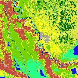
The MCD12Q1 V6 product provides global land cover types at yearly intervals (2001-2016) derived from six different classification schemes. It is derived using supervised classifications of MODIS Terra and Aqua reflectance data. The supervised classifications then undergo additional post-processing that incorporate prior knowledge and ancillary information to further refine specific classes.
Documentation:
Bands
Pixel Size 500 meters
Bands
| Name | Units | Min | Max | Pixel Size | Description |
|---|---|---|---|---|---|
LC_Type1
|
meters | Land Cover Type 1: Annual International Geosphere-Biosphere Programme (IGBP) classification |
|||
LC_Type2
|
meters | Land Cover Type 2: Annual University of Maryland (UMD) classification |
|||
LC_Type3
|
meters | Land Cover Type 3: Annual Leaf Area Index (LAI) classification |
|||
LC_Type4
|
meters | Land Cover Type 4: Annual BIOME-Biogeochemical Cycles (BGC) classification |
|||
LC_Type5
|
meters | Land Cover Type 5: Annual Plant Functional Types classification |
|||
LC_Prop1_Assessment
|
% | 0 | 100 | meters | LCCS1 land cover layer confidence |
LC_Prop2_Assessment
|
% | 0 | 100 | meters | LCCS2 land use layer confidence |
LC_Prop3_Assessment
|
% | 0 | 100 | meters | LCCS3 surface hydrology layer confidence |
LC_Prop1
|
meters | FAO-Land Cover Classification System 1 (LCCS1) land cover layer |
|||
LC_Prop2
|
meters | FAO-LCCS2 land use layer |
|||
LC_Prop3
|
meters | FAO-LCCS3 surface hydrology layer |
|||
QC
|
meters | Product quality flags |
|||
LW
|
meters | Binary land (class 2) / water (class 1) mask derived from MOD44W |
LC_Type1 Class Table
| Value | Color | Description |
|---|---|---|
|
1
|
#05450a | Evergreen Needleleaf Forests: dominated by evergreen conifer trees (canopy >2m). Tree cover >60%. |
|
2
|
#086a10 | Evergreen Broadleaf Forests: dominated by evergreen broadleaf and palmate trees (canopy >2m). Tree cover >60%. |
|
3
|
#54a708 | Deciduous Needleleaf Forests: dominated by deciduous needleleaf (larch) trees (canopy >2m). Tree cover >60%. |
|
4
|
#78d203 | Deciduous Broadleaf Forests: dominated by deciduous broadleaf trees (canopy >2m). Tree cover >60%. |
|
5
|
#009900 | Mixed Forests: dominated by neither deciduous nor evergreen (40-60% of each) tree type (canopy >2m). Tree cover >60%. |
|
6
|
#c6b044 | Closed Shrublands: dominated by woody perennials (1-2m height) >60% cover. |
|
7
|
#dcd159 | Open Shrublands: dominated by woody perennials (1-2m height) 10-60% cover. |
|
8
|
#dade48 | Woody Savannas: tree cover 30-60% (canopy >2m). |
|
9
|
#fbff13 | Savannas: tree cover 10-30% (canopy >2m). |
|
10
|
#b6ff05 | Grasslands: dominated by herbaceous annuals (<2m). |
|
11
|
#27ff87 | Permanent Wetlands: permanently inundated lands with 30-60% water cover and >10% vegetated cover. |
|
12
|
#c24f44 | cropland. |
|
13
|
#a5a5a5 | Urban and Built-up Lands: at least 30% impervious surface area including building materials, asphalt and vehicles. |
|
14
|
#ff6d4c | Cropland/Natural Vegetation Mosaics: mosaics of small-scale cultivation 40-60% with natural tree, shrub, or herbaceous vegetation. |
|
15
|
#69fff8 | Permanent Snow and Ice: at least 60% of area is covered by snow and ice for at least 10 months of the year. |
|
16
|
#f9ffa4 | (sand, rock, soil) areas with less than 10% vegetation. |
|
17
|
#1c0dff | Water Bodies: at least 60% of area is covered by permanent water bodies. |
LC_Type2 Class Table
| Value | Color | Description |
|---|---|---|
|
0
|
#1c0dff | Water Bodies: at least 60% of area is covered by permanent water bodies. |
|
1
|
#05450a | Evergreen Needleleaf Forests: dominated by evergreen conifer trees (canopy >2m). Tree cover >60%. |
|
2
|
#086a10 | Evergreen Broadleaf Forests: dominated by evergreen broadleaf and palmate trees (canopy >2m). Tree cover >60%. |
|
3
|
#54a708 | Deciduous Needleleaf Forests: dominated by deciduous needleleaf (larch) trees (canopy >2m). Tree cover >60%. |
|
4
|
#78d203 | Deciduous Broadleaf Forests: dominated by deciduous broadleaf trees (canopy >2m). Tree cover >60%. |
|
5
|
#009900 | Mixed Forests: dominated by neither deciduous nor evergreen (40-60% of each) tree type (canopy >2m). Tree cover >60%. |
|
6
|
#c6b044 | Closed Shrublands: dominated by woody perennials (1-2m height) >60% cover. |
|
7
|
#dcd159 | Open Shrublands: dominated by woody perennials (1-2m height) 10-60% cover. |
|
8
|
#dade48 | Woody Savannas: tree cover 30-60% (canopy >2m). |
|
9
|
#fbff13 | Savannas: tree cover 10-30% (canopy >2m). |
|
10
|
#b6ff05 | Grasslands: dominated by herbaceous annuals (<2m). |
|
11
|
#27ff87 | Permanent Wetlands: permanently inundated lands with 30-60% water cover and >10% vegetated cover. |
|
12
|
#c24f44 | cropland. |
|
13
|
#a5a5a5 | Urban and Built-up Lands: at least 30% impervious surface area including building materials, asphalt and vehicles. |
|
14
|
#ff6d4c | Cropland/Natural Vegetation Mosaics: mosaics of small-scale cultivation 40-60% with natural tree, shrub, or herbaceous vegetation. |
|
15
|
#f9ffa4 | Non-Vegetated Lands: at least 60% of area is non-vegetated barren (sand, rock, soil) or permanent snow and ice with less than 10% vegetation. |
LC_Type3 Class Table
| Value | Color | Description |
|---|---|---|
|
0
|
#1c0dff | Water Bodies: at least 60% of area is covered by permanent water bodies. |
|
1
|
#b6ff05 | Grasslands: dominated by herbaceous annuals (<2m) including cereal croplands. |
|
2
|
#dcd159 | Shrublands: shrub (1-2m) cover >10%. |
|
3
|
#c24f44 | Broadleaf Croplands: bominated by herbaceous annuals (<2m) that are cultivated with broadleaf crops. |
|
4
|
#fbff13 | Savannas: between 10-60% tree cover (>2m). |
|
5
|
#086a10 | Evergreen Broadleaf Forests: dominated by evergreen broadleaf and palmate trees (canopy >2m). Tree cover >60%. |
|
6
|
#78d203 | Deciduous Broadleaf Forests: dominated by deciduous broadleaf trees (canopy >2m). Tree cover >60%. |
|
7
|
#05450a | Evergreen Needleleaf Forests: dominated by evergreen conifer trees (canopy >2m). Tree cover >60%. |
|
8
|
#54a708 | Deciduous Needleleaf Forests: dominated by deciduous needleleaf (larch) trees (canopy >2m). Tree cover >60%. |
|
9
|
#f9ffa4 | Non-Vegetated Lands: at least 60% of area is non-vegetated barren (sand, rock, soil) or permanent snow and ice with less than 10% vegetation. |
|
10
|
#a5a5a5 | Urban and Built-up Lands: at least 30% impervious surface area including building materials, asphalt and vehicles. |
LC_Type4 Class Table
| Value | Color | Description |
|---|---|---|
|
0
|
#1c0dff | Water Bodies: at least 60% of area is covered by permanent water bodies. |
|
1
|
#05450a | Evergreen Needleleaf Vegetation: dominated by evergreen conifer trees and shrubs (>1m). Woody vegetation cover >10%. |
|
2
|
#086a10 | Evergreen Broadleaf Vegetation: dominated by evergreen broadleaf and palmate trees and shrubs (>1m). Woody vegetation cover
|
|
3
|
#54a708 | Deciduous Needleleaf Vegetation: dominated by deciduous needleleaf (larch) trees and shrubs (>1m). Woody vegetation cover
|
|
4
|
#78d203 | Deciduous Broadleaf Vegetation: dominated by deciduous broadleaf trees and shrubs (>1m). Woody vegetation cover >10%. |
|
5
|
#009900 | Annual Broadleaf Vegetation: dominated by herbaceous annuals (<2m). At least 60% cultivated broadleaf crops. |
|
6
|
#b6ff05 | Annual Grass Vegetation: dominated by herbaceous annuals (<2m) including cereal croplands. |
|
7
|
#f9ffa4 | Non-Vegetated Lands: at least 60% of area is non-vegetated barren (sand, rock, soil) or permanent snow/ice with less than 10% vegetation. |
|
8
|
#a5a5a5 | Urban and Built-up Lands: at least 30% impervious surface area including building materials, asphalt, and vehicles. |
LC_Type5 Class Table
| Value | Color | Description |
|---|---|---|
|
0
|
#1c0dff | Water Bodies: at least 60% of area is covered by permanent water bodies. |
|
1
|
#05450a | Evergreen Needleleaf Trees: dominated by evergreen conifer trees (>2m). Tree cover >10%. |
|
2
|
#086a10 | Evergreen Broadleaf Trees: dominated by evergreen broadleaf and palmate trees (>2m). Tree cover >10%. |
|
3
|
#54a708 | Deciduous Needleleaf Trees: dominated by deciduous needleleaf (larch) trees (>2m). Tree cover >10%. |
|
4
|
#78d203 | Deciduous Broadleaf Trees: dominated by deciduous broadleaf trees (>2m). Tree cover >10%. |
|
5
|
#dcd159 | Shrub: Shrub (1-2m) cover >10%. |
|
6
|
#b6ff05 | not cultivated. |
|
7
|
#dade48 | Cereal Croplands: dominated by herbaceous annuals (<2m). At least 60% cultivated cereal crops. |
|
8
|
#c24f44 | Broadleaf Croplands: dominated by herbaceous annuals (<2m). At least 60% cultivated broadleaf crops. |
|
9
|
#a5a5a5 | Urban and Built-up Lands: at least 30% impervious surface area including building materials, asphalt, and vehicles. |
|
10
|
#69fff8 | Permanent Snow and Ice: at least 60% of area is covered by snow and ice for at least 10 months of the year. |
|
11
|
#f9ffa4 | Non-Vegetated Lands: at least 60% of area is non-vegetated barren (sand, rock, soil) with less than 10% vegetation. |
LC_Prop1 Class Table
| Value | Color | Description |
|---|---|---|
|
1
|
#f9ffa4 | (sand, rock, soil) or permanent snow/ice with less than 10% vegetation. |
|
2
|
#69fff8 | Permanent Snow and Ice: at least 60% of area is covered by snow and ice for at least 10 months of the year. |
|
3
|
#1c0dff | Water Bodies: at least 60% of area is covered by permanent water bodies. |
|
11
|
#05450a | Evergreen Needleleaf Forests: dominated by evergreen conifer trees (>2m). Tree cover >60%. |
|
12
|
#086a10 | Evergreen Broadleaf Forests: dominated by evergreen broadleaf and palmate trees (>2m). Tree cover >60%. |
|
13
|
#54a708 | Deciduous Needleleaf Forests: dominated by deciduous needleleaf (larch) trees (>2m). Tree cover >60%. |
|
14
|
#78d203 | Deciduous Broadleaf Forests: dominated by deciduous broadleaf trees (>2m). Tree cover >60%. |
|
15
|
#005a00 | Mixed Broadleaf/Needleleaf Forests: co-dominated (40-60%) by broadleaf deciduous and evergreen needleleaf tree (>2m) types. Tree cover >60%. |
|
16
|
#009900 | Mixed Broadleaf Evergreen/Deciduous Forests: co-dominated (40-60%) by broadleaf evergreen and deciduous tree (>2m) types. Tree cover >60%. |
|
21
|
#006c00 | Open Forests: tree cover 30-60% (canopy >2m). |
|
22
|
#00d000 | Sparse Forests: tree cover 10-30% (canopy >2m). |
|
31
|
#b6ff05 | Dense Herbaceous: dominated by herbaceous annuals (<2m) at least 60% cover. |
|
32
|
#98d604 | Sparse Herbaceous: dominated by herbaceous annuals (<2m) 10-60% cover. |
|
41
|
#dcd159 | Dense Shrublands: dominated by woody perennials (1-2m)
|
|
42
|
#f1fb58 | Shrubland/Grassland Mosaics: dominated by woody perennials (1-2m) 10-60% cover with dense herbaceous annual understory. |
|
43
|
#fbee65 | Sparse Shrublands: dominated by woody perennials (1-2m) 10-60% cover with minimal herbaceous understory. |
LC_Prop2 Class Table
| Value | Color | Description |
|---|---|---|
|
1
|
#f9ffa4 | (sand, rock, soil) or permanent snow/ice with less than 10% vegetation. |
|
2
|
#69fff8 | Permanent Snow and Ice: at least 60% of area is covered by snow and ice for at least 10 months of the year. |
|
3
|
#1c0dff | Water Bodies: at least 60% of area is covered by permanent water bodies. |
|
9
|
#a5a5a5 | Urban and Built-up Lands: at least 30% of area is made up ofimpervious surfaces including building materials, asphalt, and vehicles. |
|
10
|
#003f00 | Dense Forests: tree cover >60% (canopy >2m). |
|
20
|
#006c00 | Open Forests: tree cover 10-60% (canopy >2m). |
|
25
|
#e3ff77 | Forest/Cropland Mosaics: mosaics of small-scale cultivation 40-60% with >10% natural tree cover. |
|
30
|
#b6ff05 | Natural Herbaceous: dominated by herbaceous annuals (<2m). At least 10% cover. |
|
35
|
#93ce04 | Natural Herbaceous/Croplands Mosaics: mosaics of small-scale cultivation 40-60% with natural shrub or herbaceous vegetation. |
|
36
|
#77a703 | Herbaceous Croplands: dominated by herbaceous annuals (<2m). At least 60% cover. Cultivated fraction >60%. |
|
40
|
#dcd159 | Shrublands: shrub cover >60% (1-2m). |
LC_Prop3 Class Table
| Value | Color | Description |
|---|---|---|
|
1
|
#f9ffa4 | (sand, rock, soil) or permanent snow/ice with less than 10% vegetation. |
|
2
|
#69fff8 | Permanent Snow and Ice: at least 60% of area is covered by snow and ice for at least 10 months of the year. |
|
3
|
#1c0dff | Water Bodies: at least 60% of area is covered by permanent water bodies. |
|
10
|
#003f00 | Dense Forests: tree cover >60% (canopy >2m). |
|
20
|
#006c00 | Open Forests: tree cover 10-60% (canopy >2m). |
|
27
|
#72834a | Woody Wetlands: shrub and tree cover >10% (>1m). Permanently or seasonally inundated. |
|
30
|
#b6ff05 | Grasslands: dominated by herbaceous annuals (<2m) >10% cover. |
|
40
|
#c6b044 | Shrublands: shrub cover >60% (1-2m). |
|
50
|
#3aba73 | Herbaceous Wetlands: dominated by herbaceous annuals (<2m) >10% cover. Permanently or seasonally inundated. |
|
51
|
#1e9db3 | months of the year. |
QC Class Table
| Value | Color | Description |
|---|---|---|
|
0
|
None | Classified land: has a classification label and is land according to the water mask. |
|
1
|
None | Unclassified land: not classified because of missing data but land according to the water mask, labeled as barren. |
|
2
|
None | Classified water: has a classification label and is water according to the water mask. |
|
3
|
None | Unclassified water: not classified because of missing data but water according to the water mask. |
|
4
|
None | Classified sea ice: classified as snow/ice but water mask says it is water and less than 100m elevation, switched to water. |
|
5
|
None | Misclassified water: classified as water but water mask says it is land, switched to secondary label. |
|
6
|
None | Omitted snow/ice: land according to the water mask that was classified as something other than snow but with a maximum annual temperature below 1°C, relabeled as snow/ice. |
|
7
|
None | Misclassified snow/ice: land according to the water mask that was classified as snow but with a minimum annual temperature greater than 1°C, relabeled as barren. |
|
8
|
None | Backfilled label: missing label from stabilization, filled with the pre-stabilized result. |
|
9
|
None | Forest type changed: climate-based change to forest class. |
LW Class Table
| Value | Color | Description |
|---|---|---|
|
1
|
#1c0dff | Water |
|
2
|
#f9ffa4 | Land, |
Terms of Use
Terms of Use
MODIS data and products acquired through the LP DAAC have no restrictions on subsequent use, sale, or redistribution.
Citations
-
Please visit LP DAAC 'Citing Our Data' page for information on citing LP DAAC datasets.
DOIs
Explore with Earth Engine
Code Editor (JavaScript)
 var

 dataset

 =

 ee
 .
 ImageCollection
 (
 'MODIS/006/MCD12Q1'
 );
 var

 igbpLandCover

 =

 dataset
 .
 select
 (
 'LC_Type1'
 );
 var

 igbpLandCoverVis

 =

 {

 min
 :

 1.0
 ,

 max
 :

 17.0
 ,

 palette
 :

 [

 '05450a'
 ,

 '086a10'
 ,

 '54a708'
 ,

 '78d203'
 ,

 '009900'
 ,

 'c6b044'
 ,

 'dcd159'
 ,

 'dade48'
 ,

 'fbff13'
 ,

 'b6ff05'
 ,

 '27ff87'
 ,

 'c24f44'
 ,

 'a5a5a5'
 ,

 'ff6d4c'
 ,

 '69fff8'
 ,

 'f9ffa4'
 ,

 '1c0dff'

 ],
 };
 Map
 .
 setCenter
 (
 6.746
 ,

 46.529
 ,

 6
 );
 Map
 .
 addLayer
 (
 igbpLandCover
 ,

 igbpLandCoverVis
 ,

 'IGBP Land Cover'
 );