
Page Summary
-
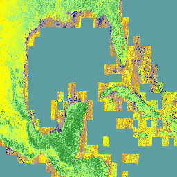
The ECOSTRESS Tiled Ancillary NDVI and Albedo (ECO_L2T_STARS) V002 dataset provides NDVI and albedo data at a 70m spatial resolution from 2018-07-09 to 2025-10-09 with a daily cadence.
-
This dataset is created by fusing VIIRS and HLS data using the STARS algorithm and is useful for understanding plant water needs and stress.
-
The dataset includes bands for NDVI and albedo, along with their uncertainty, and is freely accessible from the LP DAAC NASA.
-
The data is available through Google Earth Engine for scientific analysis and visualization.
- Dataset Availability
- 2018-07-09T00:00:00Z–2026-03-27T00:00:00Z
- Dataset Producer
- Land Processes Distributed Active Archive Center
- Cadence
- 1 Day
- Tags
Description
The ECOSTRESS Tiled Ancillary NDVI and Albedo (ECO_L2T_STARS) V002 dataset provides Normalized Difference Vegetation Index (NDVI) and albedo data at a 70m spatial resolution. This ancillary product, essential for understanding plant water needs and stress, is created through a data fusion process that combines Visible Infrared Imaging Radiometer Suite (VIIRS) and Harmonized Landsat Sentinel (HLS) data. The fusion is performed using the STARS algorithm, a Bayesian timeseries methodology, to align the data with daytime ECOSTRESS overpasses. This product is only generated for corresponding ECOSTRESS Land Surface Temperature and Emissivity tiles.
Documentation:
Bands
Bands
Pixel size: 70 meters (all bands)
| Name | Pixel Size | Description |
|---|---|---|
NDVI
|
70 meters | Normalized Difference Vegetation Index (NDVI) |
NDVI-UQ
|
70 meters | Normalized Difference Vegetation Index (NDVI) uncertainty. |
albedo
|
70 meters | Albedo |
albedo-UQ
|
70 meters | Albedo uncertainty. |
Terms of Use
Terms of Use
LP DAAC NASA data are freely accessible; however, when an author publishes these data or works based on the data, it is requested that the author cite the datasets within the text of the publication and include a reference to them in the reference list.
Citations
-
Hook, Simon, et al. ECOSTRESS Tiled Ancillary NDVI and Albedo L2 Global 70 m v002. NASA Land Processes Distributed Active Archive Center, 2023, doi: 10.5067/ECOSTRESS/ECO_L2T_STARS.002
DOIs
Explore with Earth Engine
Code Editor (JavaScript)
 var

 dataset

 =

 ee
 .
 ImageCollection
 (
 'NASA/ECOSTRESS/L2T_STARS/V2'
 )

 .
 filter
 (
 ee
 .
 Filter
 .
 date
 (
 '2025-03-01'
 ,

 '2025-05-01'
 ));
 var

 NDVI

 =

 dataset
 .
 select
 (
 'NDVI'
 ).
 mean
 ();
 var

 vis

 =

 {

 min
 :

 -
 1.0
 ,

 max
 :

 1.0
 ,

 palette
 :

 [
 '00008B'
 ,

 'A9A9A9'
 ,

 'CD853F'
 ,

 'FFFF00'
 ,

 '90EE90'
 ,

 '006400'
 ],
 };
 Map
 .
 setCenter
 (
 -
 77.1056
 ,

 38.8904
 ,

 10
 );
 Map
 .
 addLayer
 (
 NDVI
 ,

 vis
 ,

 'NDVI'
 );