
Page Summary
-
This dataset is a 15-meter resolution image mosaic of the Greenland ice sheet from 1999 to 2002, created from Landsat 7 ETM+ and RADARSAT-1 SAR imagery.
-
The dataset was processed using methods including cloud masking, pan sharpening, image sampling, resizing, and coregistration.
-
Users may find it useful to mask areas outside the Greenland coastline using the corresponding ocean mask image.
-
SAR data, originally at 20m resolution, was up-sampled to 15m using bilinear interpolation to match Landsat band-8 resolution.
-
Proper citation of the dataset is required for its use.
- Dataset Availability
- 1999-06-30T00:00:00Z–2002-09-04T00:00:00Z
- Dataset Producer
- NASA NSIDC DAAC at CIRES
- Tags
Description
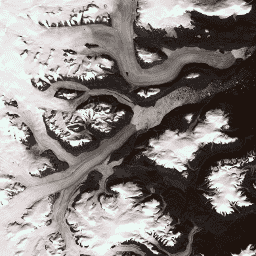
This dataset provides a complete 15 m resolution image mosaic of the Greenland ice sheet derived from Landsat 7 ETM+ and RADARSAT-1 SAR imagery from the years 1999 to 2002. The methods include a combination of image cloud masking, pan sharpening, image sampling and resizing, and image coregistration. Please see Howat, 2014 for more information regarding processing methods.
Note
- Users of GIMP DEM or GIMP 2000 Image Mosaic images may find it helpful to mask out areas outside of the Greenland coastline using the corresponding 15 m ocean mask image Greenland Ice Mapping Project (GIMP) Land Ice and Ocean Classification Mask,
- The SAR data are distributed at 20 m resolution. Data were up-sampled through bilinear interpolation to 15 m to match the resolution of Landsat band-8.
Bands
Bands
Pixel size: varies
| Name | Pixel Size | Wavelength | Description |
|---|---|---|---|
B1
|
15 meters | 0.45 - 0.52 μm | Landsat 7 ETM+ blue |
B2
|
15 meters | 0.52 - 0.60 μm | Landsat 7 ETM+ green |
B3
|
15 meters | 0.63 - 0.69 μm | Landsat 7 ETM+ red |
B4
|
15 meters | 0.77 - 0.90 μm | Landsat 7 ETM+ near infrared |
B5
|
30 meters | 1.55 - 1.75 μm | Landsat 7 ETM+ shortwave infrared 1 |
B6_low_gain
|
30 meters | 10.40 - 12.50 μm | Landsat 7 ETM+ low-gain thermal Infrared 1. This band has expanded dynamic range and lower radiometric resolution (sensitivity), with less saturation at high Digital Number (DN) values. Resampled from 60m to 30m. |
B6_high_gain
|
30 meters | 10.40 - 12.50 μm | Landsat 7 ETM+ high-gain thermal Infrared 1. This band has higher radiometric resolution (sensitivity), although it has a more restricted dynamic range. Resampled from 60m to 30m. |
B7
|
30 meters | 2.08 - 2.35 μm | Landsat 7 ETM+ shortwave infrared 2 |
B8
|
15 meters | 0.52 - 0.90 μm | Landsat 7 ETM+ panchromatic |
B8_radarsat
|
15 meters | None | RADARSAT-1 synthetic aperture radar amplitude imagery |
Terms of Use
Terms of Use
As a condition of using these data, you must cite the use of this data set using the given citation.
Citations
-
Howat, I.M., A. Negrete, B.E. Smith, 2014, The Greenland Ice Mapping Project (GIMP) land classification and surface elevation datasets, The Cryosphere, 8, 1509-1518, doi:10.5194/tc-8-1509-2014 article pdf
DOIs
Explore with Earth Engine
Code Editor (JavaScript)
 var

 dataset

 =

 ee
 .
 Image
 (
 'OSU/GIMP/2000_IMAGERY_MOSAIC'
 );
 var

 greenlandImage

 =

 dataset
 .
 select
 ([
 'B3'
 ,

 'B2'
 ,

 'B1'
 ]);
 var

 visParams

 =

 {

 min
 :

 0.0
 ,

 max
 :

 255.0
 ,
 };
 Map
 .
 setCenter
 (
 -
 29.1605
 ,

 70.4
 ,

 9
 );
 Map
 .
 addLayer
 (
 greenlandImage
 ,

 visParams
 ,

 'Greenland Pansharpened Image'
 );