NOAA Issues Map Pointing to Heavier Rain and Snow Across Several States From October Through December
- The National Weather Service has released a seasonal precipitation outlook map for October, November, and December 2026, showing which states may experience heavier snow and rain during that time period.
The National Weather Service has recently issued a map that showcases its seasonal precipitation outlook for the United States in the coming months. According to the map, the agency's forecasters are pointing to several states potentially facing heavier snow and rain from October through December.
Where Heavier Snow and Rain Could Arrive in America in October, November, and December
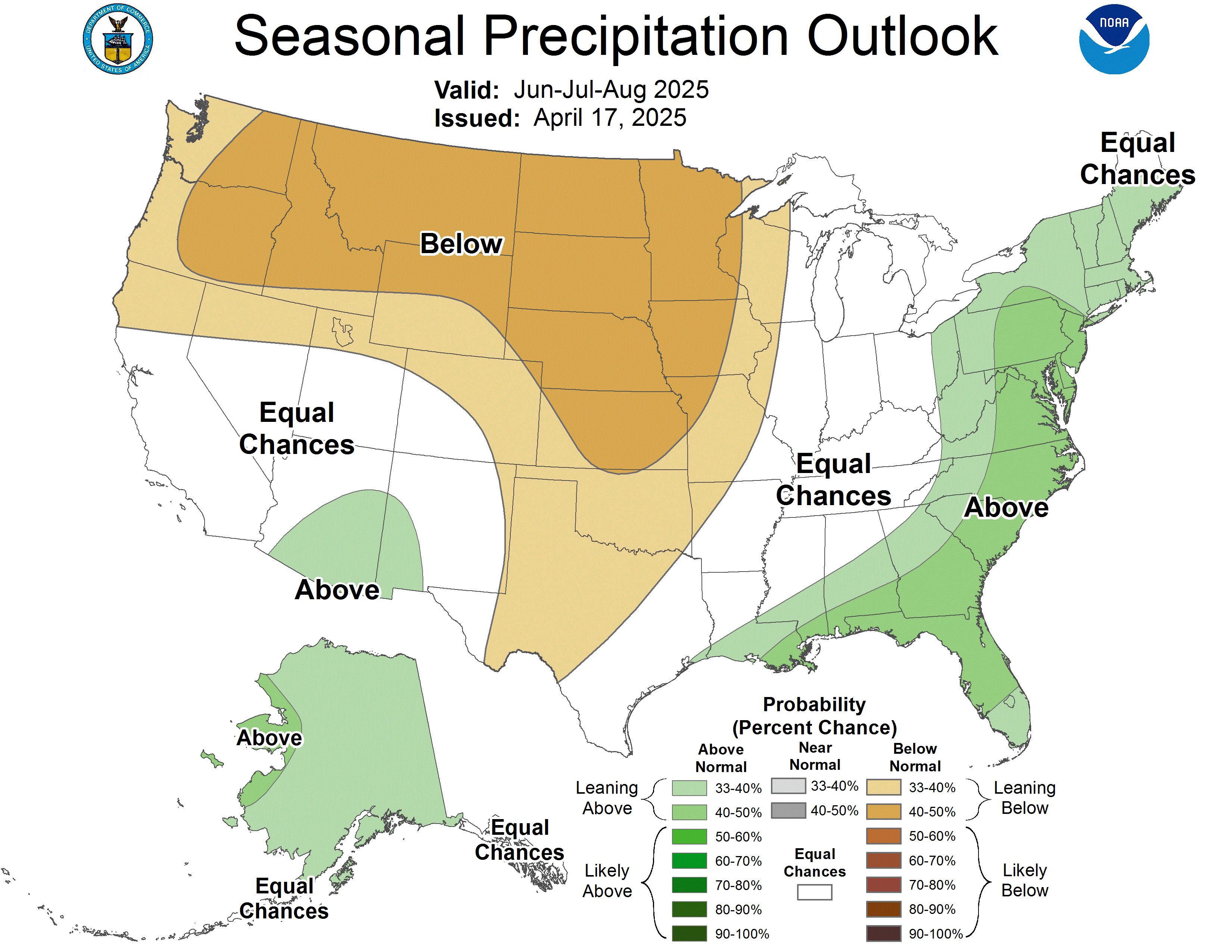
On August 20, 2026, the National Weather Service's Climate Prediction Center published a seasonal precipitation outlook map for October, November, and December 2026. The image shows which states are the most likely to face heavier snow and rain during the final three months of the year.
The green areas of the map, which can be seen below, signify parts of the country that could see higher levels of rain or snow than the typical amount they face. Conversely, forecasters have determined that the brown areas may have to cope with lower levels of precipitation in the coming months. The white part of the map signifies the areas where there are "equal chances" of above-average, below-average, or average precipitation.
According to the map, there is a 33% to 50% likelihood that parts of or all of 20 states will face heavier snow or rain in October, November, and December:
-
Parts of California, Arizona, Nevada, Utah, Colorado, South Dakota, Kansas, Oklahoma, Arkansas, Mississippi, Alabama, Georgia, South Carolina, North Carolina, and Alaska.
-
All of New Mexico, Texas, Nebraska, Louisiana, and Florida.
Alternatively, the National Weather Service's Climate Prediction Center is forecasting that only parts of six states are facing a 33% to 40% chance of below-average precipitation:
-
Parts of Washington, Oregon, Idaho, Montana, Michigan, and Alaska
Interestingly, Alaska is the only state that has part of it colored green and a different area covered in brown on the map. The rest of that state, and the other ones that weren't previously named, fall under the "equal chances" category.

A detailed United States Climate Prediction Center seasonal precipitation outlook map.Credit: National Weather Service's Climate Prediction Center
The National Weather Service's Climate Prediction Center seasonal precipitation outlook map doesn't contain any information about what is expected to fall. That means that it doesn't include any indication about whether the conditions it points to will result in snow, rain, or a combination of both.
Next: Winter Storm Travel Kit Safety Experts Share the Must-Have Items Drivers Often Forget
This story was originally published by Men's Journal on Sep 4, 2026, where it first appeared in the News section. Add Men's Journal as a Preferred Source by clicking here.