

Page Summary
-
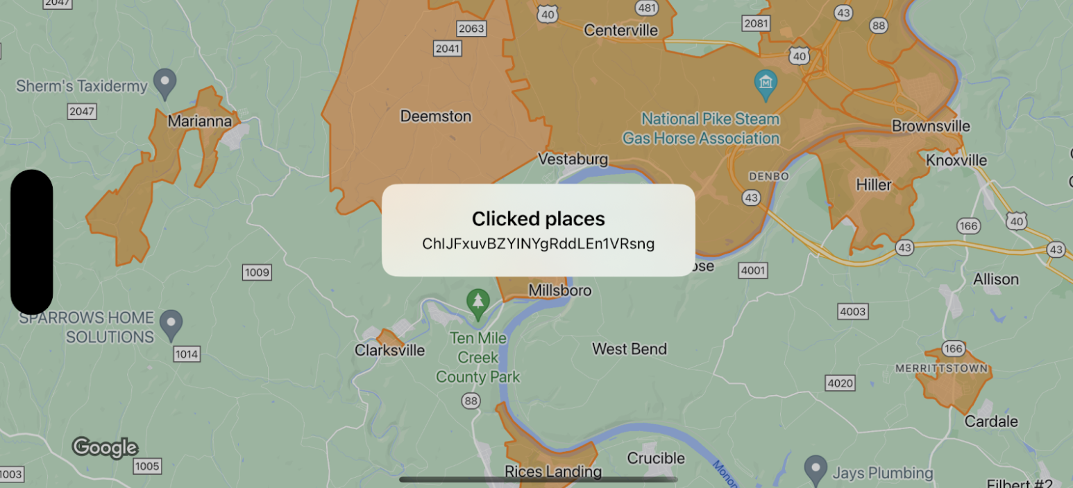
This documentation demonstrates handling click events on map boundaries, specifically using
GMSFeatureTypeLocalityfor the example. -
When a boundary is clicked, an info window appears displaying event data, such as the place IDs of the clicked features.
-
It's crucial to note that map boundaries need a minimum alpha value for click events to register, ensuring they are tappable.
-
Sample code snippets in Swift and Objective-C are provided for implementation guidance on setting up and responding to click events on map boundaries.
This example shows map boundaries for GMSFeatureTypeLocality
, and implements the delegate
function that styles the clicked
polygon. The result displays an info alert window with the event data.
Swift
 class

 SampleViewController
 :

 UIViewController

 {

 private

 lazy

 var

 mapView
 :

 GMSMapView

 =

 GMSMapView
 (
 frame
 :

 .
 zero
 ,

 mapID
 :

 GMSMapID
 (
 identifier
 :

 "YOUR_MAP_ID"
 ),

 camera
 :

 GMSCameraPosition
 (
 latitude
 :

 40
 ,

 longitude
 :

 -
 80
 ,

 zoom
 :

 12
 ))

 override

 func

 loadView
 ()

 {

 view

 =

 mapView

 let

 style

 =

 FeatureStyle
 (
 fill
 :

 .
 orange
 .
 withAlphaComponent
 (
 0.5
 ),

 stroke
 :

 .
 orange
 ,

 strokeWidth
 :

 2
 )

 mapView
 .
 featureLayer
 (
 of
 :

 .
 locality
 ).
 style

 =

 {

 _

 in

 style

 }

 mapView
 .
 delegate

 =

 self

 }
 }
 extension

 SampleViewController
 :

 GMSMapViewDelegate

 {

 func

 mapView
 (
 _

 mapView
 :

 GMSMapView
 ,

 didTap

 features
 :

[ Feature
] ,

 in

 featureLayer
 :

 FeatureLayer<Feature>
 ,

 atLocation
 :

 CLLocationCoordinate2D
 )

 {

 let

 toast

 =

 UIAlertController
 (
 title
 :

 "Clicked places"
 ,

 message
 :

 (
 features
 .
 compactMap

 {

 (
 $0

 as
 ?

 PlaceFeature
 )?.
 placeID

 }).
 joined
 (
 separator
 :

 ", "
 ),

 preferredStyle
 :

 .
 alert
 )

 present
 (
 toast
 ,

 animated
 :

 true
 ,

 completion
 :

 nil
 )

 }
 }
Objective-C
 @interface
 SampleViewController
: UIViewController

< GMSMapViewDelegate
> @end
 @implementation
 SampleViewController
 -
 (
 void
 )
 loadView

 {

 GMSMapView

 *
 mapView

 =

 [
 GMSMapView

 mapWithFrame
 :
 CGRectZero

 mapID
 :
 [
 GMSMapID

 mapIDWithIdentifier
 :
 @"YOUR_MAP_ID"
 ]

 camera
 :
 [
 GMSCameraPosition

 cameraWithLatitude
 :
 40

 longitude
 :
 -80

 zoom
 :
 12
 ]];

 mapView
 .
 delegete

 =

 self
 ;

 GMSFeatureStyle

 *
 style

 =

 [
 GMSFeatureStyle

 styleWithFillColor
 :
 [[
 UIColor

 orangeColor
 ]

 colorWithAlphaComponent
 :
 0.5
 ]

 strokeColor
 :
 [
 UIColor

 orangeColor
 ]

 strokeWidth
 :
 2.0
 ];

 [
 mapView

 featureLayerOfFeatureType
 :
 GMSFeatureTypeLocality
 ].
 style

 =

 ^
 (
 GMSPlaceFeature

 *
 feature
 )

 {

 return

 style
 ;

 };

 self
 .
 view

 =

 mapView
 ;
 }
 -
 (
 void
 )
 mapView:
 (
 GMSMapView

 *
 )
 mapView

 didTapFeatures:
 (
 NSArray<id<GMSFeature>
>
 *
 )
 features

 inFeatureLayer:
 (
 GMSFeatureLayer

 *
 )
 featureLayer

 atLocation:
 (
 CLLocationCoordinate2D
 )
 location

 {

 NSMutableArray<NSString

 *
>
 *
 places

 =

 [
 NSMutableArray

 array
 ];

 for

 (
 id<GMSFeature>

 feature

 in

 features
 )

 {

 if

 (
 !
 [
 feature

 isKindOfClass
 :
 [
 GMSPlaceFeature

 class
 ]])

 {

 continue
 ;

 }

 NSString

 *
 placeID

 =

 ((
 GMSPlaceFeature

 *
 )
 feature
 ).
 placeID
 ;

 [
 places

 addObject
 :
 placeID
 ];

 }

 UIAlertController

 *
 toast

 =

 [
 UIAlertController

 alertControllerWithTitle
 :
 @"Clicked places"

 message
 :
 [
 places

 componentsJoinedByString
 :
 @", "
 ]

 preferredStyle
 :
 UIAlertControllerStyleAlert
 ];

 [
 self

 presentViewController
 :
 toast

 animated
 :
 YES

 completion
 :
 nil
 ];
 }