
AI-generated Key Takeaways
-
The ASTER AST_L1T_003 dataset provides multispectral imagery from 2000 to 2025, with a revisit interval of 16 days.
-
Data collection for this dataset has a known gap between November 28, 2024, and January 16, 2025.
-
The ASTER instrument captures data in 14 spectral bands, ranging from visible to thermal infrared.
-
Scenes are 60x60 km and contain calibrated, ortho-rectified, and terrain-corrected radiance data.
-
A list of original bands present in each scene is available as an asset property.
- Dataset Availability
- 2000-03-04T00:00:00Z–2025-11-15T23:01:03Z
- Dataset Provider
- NASA LP DAAC at the USGS EROS Center
- Revisit Interval
- 16 Days
- Tags
Description
Note:There is a gap in data collection between November 28, 2024 and January 16, 2025 due to technical issues with the ASTER instrument. See the USGS announcement for more information.
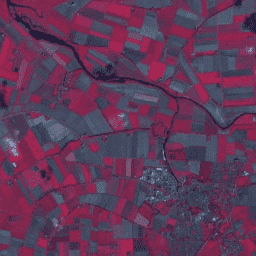
The Advanced Spaceborne Thermal Emission and Reflection Radiometer (ASTER) is a multispectral imager that was launched on board NASA's Terra spacecraft in December, 1999. ASTER can collect data in 14 spectral bands from the visible to the thermal infrared. Each scene covers an area of 60 x 60 km. These scenes, produced by the USGS, contain calibrated at-sensor radiance, ortho-rectified and terrain corrected.
Not all 14 bands were collected in each scene. An asset property named ORIGINAL_BANDS_PRESENT contains the list of bands that are present in each scene.
To convert from Digital Numbers (DN) to radiance at the sensor, the unit conversion coefficients are available in the metadata. See ASTER L1T Product Users' Guide and ASTER L1T Product Specification for more information.
Documentation:
Bands
Bands
| Name | Min | Max | Pixel Size | Wavelength | Description |
|---|---|---|---|---|---|
B01
|
1 | 255 | 15 meters | 0.520-0.600μm | VNIR_Band1 (visible green/yellow) |
B02
|
1 | 255 | 15 meters | 0.630-0.690μm | VNIR_Band2 (visible red) |
B3N
|
1 | 255 | 15 meters | 0.780-0.860μm | VNIR_Band3N (near infrared, nadir pointing) |
B04
|
1 | 255 | 30 meters | 1.600-1.700μm | SWIR_Band4 (short-wave infrared) |
B05
|
1 | 255 | 30 meters | 2.145-2.185μm | SWIR_Band5 (short-wave infrared) |
B06
|
1 | 255 | 30 meters | 2.185-2.225μm | SWIR_Band6 (short-wave infrared) |
B07
|
1 | 255 | 30 meters | 2.235-2.285μm | SWIR_Band7 (short-wave infrared) |
B08
|
1 | 255 | 30 meters | 2.295-2.365μm | SWIR_Band8 (short-wave infrared) |
B09
|
1 | 255 | 30 meters | 2.360-2.430μm | SWIR_Band9 (short-wave infrared) |
B10
|
1 | 4095 | 90 meters | 8.125-8.475μm | TIR_Band10 (thermal infrared) |
B11
|
1 | 4095 | 90 meters | 8.475-8.825μm | TIR_Band11 (thermal infrared) |
B12
|
1 | 4095 | 90 meters | 8.925-9.275μm | TIR_Band12 (thermal infrared) |
B13
|
1 | 4095 | 90 meters | 10.250-10.950μm | TIR_Band13 (thermal infrared) |
B14
|
1 | 4095 | 90 meters | 10.950-11.650μm | TIR_Band14 (thermal infrared) |
Image Properties
Image Properties
| Name | Type | Description |
|---|---|---|
|
BAD_PIXELS_B01
|
DOUBLE | Number of bad pixels |
|
BAD_PIXELS_B02
|
DOUBLE | Number of bad pixels |
|
BAD_PIXELS_B03
|
DOUBLE | Number of bad pixels |
|
BAD_PIXELS_B04
|
DOUBLE | Number of bad pixels |
|
BAD_PIXELS_B05
|
DOUBLE | Number of bad pixels |
|
BAD_PIXELS_B06
|
DOUBLE | Number of bad pixels |
|
BAD_PIXELS_B07
|
DOUBLE | Number of bad pixels |
|
BAD_PIXELS_B08
|
DOUBLE | Number of bad pixels |
|
BAD_PIXELS_B09
|
DOUBLE | Number of bad pixels |
|
BAD_PIXELS_B10
|
DOUBLE | Number of bad pixels |
|
BAD_PIXELS_B11
|
DOUBLE | Number of bad pixels |
|
BAD_PIXELS_B12
|
DOUBLE | Number of bad pixels |
|
BAD_PIXELS_B13
|
DOUBLE | Number of bad pixels |
|
BAD_PIXELS_B14
|
DOUBLE | Number of bad pixels |
|
CLOUDCOVER
|
DOUBLE | Cloud coverage |
|
COARSE_DEM_DATE
|
STRING | Coarse DEM issuance date |
|
COARSE_DEM_NOTE
|
STRING | Coarse DEM comments |
|
COARSE_DEM_VERSION
|
STRING | Coarse DEM version number |
|
FLYING_DIRECTION
|
STRING | The satellite flight direction when observation is done: 'AS' - ascending direction, 'DE' - descending direction |
|
GAIN_COEFFICIENT_B01
|
DOUBLE | Coefficient used for radiance conversion |
|
GAIN_COEFFICIENT_B02
|
DOUBLE | Coefficient used for radiance conversion |
|
GAIN_COEFFICIENT_B03
|
DOUBLE | Coefficient used for radiance conversion |
|
GAIN_COEFFICIENT_B04
|
DOUBLE | Coefficient used for radiance conversion |
|
GAIN_COEFFICIENT_B05
|
DOUBLE | Coefficient used for radiance conversion |
|
GAIN_COEFFICIENT_B06
|
DOUBLE | Coefficient used for radiance conversion |
|
GAIN_COEFFICIENT_B07
|
DOUBLE | Coefficient used for radiance conversion |
|
GAIN_COEFFICIENT_B08
|
DOUBLE | Coefficient used for radiance conversion |
|
GAIN_COEFFICIENT_B09
|
DOUBLE | Coefficient used for radiance conversion |
|
GAIN_COEFFICIENT_B10
|
DOUBLE | Coefficient used for radiance conversion |
|
GAIN_COEFFICIENT_B11
|
DOUBLE | Coefficient used for radiance conversion |
|
GAIN_COEFFICIENT_B12
|
DOUBLE | Coefficient used for radiance conversion |
|
GAIN_COEFFICIENT_B13
|
DOUBLE | Coefficient used for radiance conversion |
|
GAIN_COEFFICIENT_B14
|
DOUBLE | Coefficient used for radiance conversion |
|
GAIN_SETTING_B01
|
STRING | Band gain setting: 'HGH' - high, 'NOR' - normal, 'LOW' - low, 'LO1' - low 1, or 'LO2' - low 2 |
|
GAIN_SETTING_B02
|
STRING | Band gain setting: 'HGH' - high, 'NOR' - normal, 'LOW' - low, 'LO1' - low 1, or 'LO2' - low 2 |
|
GAIN_SETTING_B03
|
STRING | Band gain setting: 'HGH' - high, 'NOR' - normal, 'LOW' - low, 'LO1' - low 1, or 'LO2' - low 2 |
|
GAIN_SETTING_B04
|
STRING | Band gain setting: 'HGH' - high, 'NOR' - normal, 'LOW' - low, 'LO1' - low 1, or 'LO2' - low 2 |
|
GAIN_SETTING_B05
|
STRING | Band gain setting: 'HGH' - high, 'NOR' - normal, 'LOW' - low, 'LO1' - low 1, or 'LO2' - low 2 |
|
GAIN_SETTING_B06
|
STRING | Band gain setting: 'HGH' - high, 'NOR' - normal, 'LOW' - low, 'LO1' - low 1, or 'LO2' - low 2 |
|
GAIN_SETTING_B07
|
STRING | Band gain setting: 'HGH' - high, 'NOR' - normal, 'LOW' - low, 'LO1' - low 1, or 'LO2' - low 2 |
|
GAIN_SETTING_B08
|
STRING | Band gain setting: 'HGH' - high, 'NOR' - normal, 'LOW' - low, 'LO1' - low 1, or 'LO2' - low 2 |
|
GAIN_SETTING_B09
|
STRING | Band gain setting: 'HGH' - high, 'NOR' - normal, 'LOW' - low, 'LO1' - low 1, or 'LO2' - low 2 |
|
GAIN_SETTING_B10
|
STRING | Band gain setting: 'HGH' - high, 'NOR' - normal, 'LOW' - low, 'LO1' - low 1, or 'LO2' - low 2 |
|
GAIN_SETTING_B11
|
STRING | Band gain setting: 'HGH' - high, 'NOR' - normal, 'LOW' - low, 'LO1' - low 1, or 'LO2' - low 2 |
|
GAIN_SETTING_B12
|
STRING | Band gain setting: 'HGH' - high, 'NOR' - normal, 'LOW' - low, 'LO1' - low 1, or 'LO2' - low 2 |
|
GAIN_SETTING_B13
|
STRING | Band gain setting: 'HGH' - high, 'NOR' - normal, 'LOW' - low, 'LO1' - low 1, or 'LO2' - low 2 |
|
GAIN_SETTING_B14
|
STRING | Band gain setting: 'HGH' - high, 'NOR' - normal, 'LOW' - low, 'LO1' - low 1, or 'LO2' - low 2 |
|
GCP_CHIPS_CORRELATED
|
DOUBLE | How many chips correlated during correlation statistics creation |
|
GEOMETRIC_DB_DATE
|
STRING | Geometric correction data issuance date |
|
GEOMETRIC_DB_VERSION
|
STRING | Geometric correction data version number |
|
GRANULE_REPROCESSING
|
STRING | What reprocessing has been performed on the granule: 'not reprocessed', 'reprocessed once', 'reprocessed twice', or 'reprocessing n times' |
|
ORBIT_NUMBER
|
DOUBLE | The orbit number of the satellite when data is acquired |
|
ORIGINAL_BANDS_PRESENT
|
STRING_LIST | List of bands that are present in each scene |
|
PGE_VERSION
|
STRING | The version of PGE |
|
PRODUCTION_TIME
|
DOUBLE | Generation time of this product |
|
QA_PERCENT_INTERPOLATED_DATA
|
DOUBLE | The percentage of interpolated data in the scene |
|
QA_PERCENT_MISSING_DATA
|
DOUBLE | The percentage of missing data in the scene |
|
QA_PERCENT_OUT_OF_BOUNDS_DATA
|
DOUBLE | The percentage of out of bounds data in the scene |
|
RADIOMETRIC_DB_DATE
|
STRING | Radiometric correction data issuance date |
|
RADIOMETRIC_DB_VERSION
|
STRING | Radiometric correction data version number |
|
RESAMPLING_METHOD_B01
|
STRING | Resampling method: 'BL', 'NN', or 'CC' |
|
RESAMPLING_METHOD_B02
|
STRING | Resampling method: 'BL', 'NN', or 'CC' |
|
RESAMPLING_METHOD_B03
|
STRING | Resampling method: 'BL', 'NN', or 'CC' |
|
RESAMPLING_METHOD_B04
|
STRING | Resampling method: 'BL', 'NN', or 'CC' |
|
RESAMPLING_METHOD_B05
|
STRING | Resampling method: 'BL', 'NN', or 'CC' |
|
RESAMPLING_METHOD_B06
|
STRING | Resampling method: 'BL', 'NN', or 'CC' |
|
RESAMPLING_METHOD_B07
|
STRING | Resampling method: 'BL', 'NN', or 'CC' |
|
RESAMPLING_METHOD_B08
|
STRING | Resampling method: 'BL', 'NN', or 'CC' |
|
RESAMPLING_METHOD_B09
|
STRING | Resampling method: 'BL', 'NN', or 'CC' |
|
RESAMPLING_METHOD_B10
|
STRING | Resampling method: 'BL', 'NN', or 'CC' |
|
RESAMPLING_METHOD_B11
|
STRING | Resampling method: 'BL', 'NN', or 'CC' |
|
RESAMPLING_METHOD_B12
|
STRING | Resampling method: 'BL', 'NN', or 'CC' |
|
RESAMPLING_METHOD_B13
|
STRING | Resampling method: 'BL', 'NN', or 'CC' |
|
RESAMPLING_METHOD_B14
|
STRING | Resampling method: 'BL', 'NN', or 'CC' |
|
SATELLITE_RECURRENT_CYCLENUMBER
|
DOUBLE | The satellite recurrent cycle number |
|
SATELLITE_REVOLUTION_NUMBER
|
DOUBLE | The satellite revolution number in the cycle |
|
SCENE_PATH
|
DOUBLE | Scene path |
|
SCENE_ROW
|
DOUBLE | Scene row |
|
SCENE_VIEW
|
DOUBLE | Scene view |
|
SOLAR_AZIMUTH
|
DOUBLE | Sun direction as seen from the scene center; azimuth angle in degrees measured eastward from North (0.0<az<360) |
|
SOLAR_ELEVATION
|
DOUBLE | Sun direction as seen from the scene center; elevation angle in degrees (-90.0<el<90.0) |
|
SOURCE_DATA_GRANULE
|
STRING | ID of input AST_L1A data granule used for generating this product |
|
SWIR_POINTING_ANGLE
|
DOUBLE | Pointing angle in degrees |
|
TIR_POINTING_ANGLE
|
DOUBLE | Pointing angle in degrees |
|
VNIR_POINTING_ANGLE
|
DOUBLE | Pointing angle in degrees |
Terms of Use
Terms of Use
ASTER data and products distributed by the LP DAAC, with the exception of the ASTER Global Digital Elevation Model (GDEM) dataset (ASTGTM) version 2 (v2), have no restrictions on data use, sale, or subsequent redistribution.
Citations
-
Please visit LP DAAC 'Citing Our Data' page for information on citing LP DAAC datasets.
DOIs
Explore with Earth Engine
Code Editor (JavaScript)
 var

 dataset

 =

 ee
 .
 ImageCollection
 (
 'ASTER/AST_L1T_003'
 )

 .
 filter
 (
 ee
 .
 Filter
 .
 date
 (
 '2018-01-01'
 ,

 '2018-08-15'
 ));
 var

 falseColor

 =

 dataset
 .
 select
 ([
 'B3N'
 ,

 'B02'
 ,

 'B01'
 ]);
 var

 falseColorVis

 =

 {

 min
 :

 0.0
 ,

 max
 :

 255.0
 ,
 };
 Map
 .
 setCenter
 (
 -
 122.0272
 ,

 39.6734
 ,

 11
 );
 Map
 .
 addLayer
 (
 falseColor
 .
 median
 (),

 falseColorVis
 ,

 'False Color'
 );