
AI-generated Key Takeaways
-
The HARMONIZED collection adjusts the DN range of newer Sentinel-2 scenes to match older ones.
-
Sentinel-2 is a multi-spectral imaging mission for land monitoring with a 5-day revisit interval.
-
The data contains 13 spectral bands representing TOA reflectance scaled by 10000.
-
Each Sentinel-2 product may contain multiple granules, each becoming a separate Earth Engine asset.
-
The QA60 band, used for cloud masking, has had changes in how cloud masks are produced over time.
- Dataset Availability
- 2015-06-27T00:00:00Z–2025-11-17T08:18:19.338000Z
- Dataset Provider
- European Union/ESA/Copernicus
- Revisit Interval
- 5 Days
- Tags
Description
After 2022-01-25, Sentinel-2 scenes with PROCESSING_BASELINE '04.00' or above have their DN (value) range shifted by 1000. The HARMONIZED collection shifts data in newer scenes to be in the same range as in older scenes.
Sentinel-2 is a wide-swath, high-resolution, multi-spectral imaging mission supporting Copernicus Land Monitoring studies, including the monitoring of vegetation, soil and water cover, as well as observation of inland waterways and coastal areas.
The Sentinel-2 data contain 13 UINT16 spectral bands representing TOA reflectance scaled by 10000. See the Sentinel-2 User Handbook for details. QA60 is a bitmask band that contained rasterized cloud mask polygons until Feb 2022, when these polygons stopped being produced. Starting in February 2024, legacy-consistent QA60 bands are constructed from the MSK_CLASSI cloud classification bands. For more details, see the full explanation of how cloud masks are computed. .
Each Sentinel-2 product (zip archive) may contain multiple granules. Each granule becomes a separate Earth Engine asset. EE asset ids for Sentinel-2 assets have the following format: COPERNICUS/S2/20151128T002653_20151128T102149_T56MNN. Here the first numeric part represents the sensing date and time, the second numeric part represents the product generation date and time, and the final 6-character string is a unique granule identifier indicating its UTM grid reference (see MGRS ).
The Level-2 data produced by ESA can be found in the collection COPERNICUS/S2_SR .
For datasets to assist with cloud and/or cloud shadow detection, see COPERNICUS/S2_CLOUD_PROBABILITY and GOOGLE/CLOUD_SCORE_PLUS/V1/S2_HARMONIZED .
For more details on Sentinel-2 radiometric resolution, see this page .
Bands
Bands
B1
Aerosols
B2
Blue
B3
Green
B4
Red
B5
Red Edge 1
B6
Red Edge 2
B7
Red Edge 3
B8
NIR
B8A
Red Edge 4
B9
Water vapor
B10
Cirrus
B11
SWIR 1
B12
SWIR 2
QA10
Always empty
QA20
Always empty
QA60
Cloud mask. Masked out between February 2022 and February 2024.
MSK_CLASSI_OPAQUE
Opaque clouds classification band (0=no clouds, 1=clouds). Masked out before February 2024.
MSK_CLASSI_CIRRUS
Cirrus clouds classification band (0=no clouds, 1=clouds). Masked out before February 2024.
MSK_CLASSI_SNOW_ICE
Snow/ice classification band (0=no snow/ice, 1=snow/ice). Masked out before February 2024.
Image Properties
Image Properties
| Name | Type | Description |
|---|---|---|
|
CLOUDY_PIXEL_PERCENTAGE
|
DOUBLE | Granule-specific cloudy pixel percentage taken from the original metadata |
|
CLOUD_COVERAGE_ASSESSMENT
|
DOUBLE | Cloudy pixel percentage for the whole archive that contains this granule. Taken from the original metadata |
|
DATASTRIP_ID
|
STRING | Unique identifier of the datastrip Product Data Item (PDI) |
|
DATATAKE_IDENTIFIER
|
STRING | Uniquely identifies a given Datatake. The ID contains the Sentinel-2 satellite, start date and time, absolute orbit number, and processing baseline. |
|
DATATAKE_TYPE
|
STRING | MSI operation mode |
|
DEGRADED_MSI_DATA_PERCENTAGE
|
DOUBLE | Percentage of degraded MSI and ancillary data |
|
FORMAT_CORRECTNESS
|
STRING | Synthesis of the On-Line Quality Control (OLQC) checks performed at granule (Product_Syntax) and datastrip (Product Syntax and DS_Consistency) levels |
|
GENERAL_QUALITY
|
STRING | Synthesis of the OLQC checks performed at the datastrip level (Relative_Orbit_Number) |
|
GENERATION_TIME
|
DOUBLE | Product generation time |
|
GEOMETRIC_QUALITY
|
STRING | Synthesis of the OLQC checks performed at the datastrip level (Attitude_Quality_Indicator) |
|
GRANULE_ID
|
STRING | Unique identifier of the granule PDI (PDI_ID) |
|
MEAN_INCIDENCE_AZIMUTH_ANGLE_B1
|
DOUBLE | Mean value containing viewing incidence azimuth angle average for band B1 and for all detectors |
|
MEAN_INCIDENCE_AZIMUTH_ANGLE_B2
|
DOUBLE | Mean value containing viewing incidence azimuth angle average for band B2 and for all detectors |
|
MEAN_INCIDENCE_AZIMUTH_ANGLE_B3
|
DOUBLE | Mean value containing viewing incidence azimuth angle average for band B3 and for all detectors |
|
MEAN_INCIDENCE_AZIMUTH_ANGLE_B4
|
DOUBLE | Mean value containing viewing incidence azimuth angle average for band B4 and for all detectors |
|
MEAN_INCIDENCE_AZIMUTH_ANGLE_B5
|
DOUBLE | Mean value containing viewing incidence azimuth angle average for band B5 and for all detectors |
|
MEAN_INCIDENCE_AZIMUTH_ANGLE_B6
|
DOUBLE | Mean value containing viewing incidence azimuth angle average for band B6 and for all detectors |
|
MEAN_INCIDENCE_AZIMUTH_ANGLE_B7
|
DOUBLE | Mean value containing viewing incidence azimuth angle average for band B7 and for all detectors |
|
MEAN_INCIDENCE_AZIMUTH_ANGLE_B8
|
DOUBLE | Mean value containing viewing incidence azimuth angle average for band B8 and for all detectors |
|
MEAN_INCIDENCE_AZIMUTH_ANGLE_B8A
|
DOUBLE | Mean value containing viewing incidence azimuth angle average for band B8a and for all detectors |
|
MEAN_INCIDENCE_AZIMUTH_ANGLE_B9
|
DOUBLE | Mean value containing viewing incidence azimuth angle average for band B9 and for all detectors |
|
MEAN_INCIDENCE_AZIMUTH_ANGLE_B10
|
DOUBLE | Mean value containing viewing incidence azimuth angle average for band B10 and for all detectors |
|
MEAN_INCIDENCE_AZIMUTH_ANGLE_B11
|
DOUBLE | Mean value containing viewing incidence azimuth angle average for band B11 and for all detectors |
|
MEAN_INCIDENCE_AZIMUTH_ANGLE_B12
|
DOUBLE | Mean value containing viewing incidence azimuth angle average for band B12 and for all detectors |
|
MEAN_INCIDENCE_ZENITH_ANGLE_B1
|
DOUBLE | Mean value containing viewing incidence zenith angle average for band B1 and for all detectors |
|
MEAN_INCIDENCE_ZENITH_ANGLE_B2
|
DOUBLE | Mean value containing viewing incidence zenith angle average for band B2 and for all detectors |
|
MEAN_INCIDENCE_ZENITH_ANGLE_B3
|
DOUBLE | Mean value containing viewing incidence zenith angle average for band B3 and for all detectors |
|
MEAN_INCIDENCE_ZENITH_ANGLE_B4
|
DOUBLE | Mean value containing viewing incidence zenith angle average for band B4 and for all detectors |
|
MEAN_INCIDENCE_ZENITH_ANGLE_B5
|
DOUBLE | Mean value containing viewing incidence zenith angle average for band B5 and for all detectors |
|
MEAN_INCIDENCE_ZENITH_ANGLE_B6
|
DOUBLE | Mean value containing viewing incidence zenith angle average for band B6 and for all detectors |
|
MEAN_INCIDENCE_ZENITH_ANGLE_B7
|
DOUBLE | Mean value containing viewing incidence zenith angle average for band B7 and for all detectors |
|
MEAN_INCIDENCE_ZENITH_ANGLE_B8
|
DOUBLE | Mean value containing viewing incidence zenith angle average for band B8 and for all detectors |
|
MEAN_INCIDENCE_ZENITH_ANGLE_B8A
|
DOUBLE | Mean value containing viewing incidence zenith angle average for band B8a and for all detectors |
|
MEAN_INCIDENCE_ZENITH_ANGLE_B9
|
DOUBLE | Mean value containing viewing incidence zenith angle average for band B9 and for all detectors |
|
MEAN_INCIDENCE_ZENITH_ANGLE_B10
|
DOUBLE | Mean value containing viewing incidence zenith angle average for band B10 and for all detectors |
|
MEAN_INCIDENCE_ZENITH_ANGLE_B11
|
DOUBLE | Mean value containing viewing incidence zenith angle average for band B11 and for all detectors |
|
MEAN_INCIDENCE_ZENITH_ANGLE_B12
|
DOUBLE | Mean value containing viewing incidence zenith angle average for band B12 and for all detectors |
|
MEAN_SOLAR_AZIMUTH_ANGLE
|
DOUBLE | Mean value containing sun azimuth angle average for all bands and detectors |
|
MEAN_SOLAR_ZENITH_ANGLE
|
DOUBLE | Mean value containing sun zenith angle average for all bands and detectors |
|
MGRS_TILE
|
STRING | US-Military Grid Reference System (MGRS) tile |
|
PROCESSING_BASELINE
|
STRING | Configuration baseline used at the time of the product generation in terms of processor software version and major Ground Image Processing Parameters (GIPP) version |
|
PRODUCT_ID
|
STRING | The full id of the original Sentinel-2 product |
|
RADIOMETRIC_QUALITY
|
STRING | Based on the OLQC reports contained in the Datastrips/QI_DATA with RADIOMETRIC_QUALITY checklist name |
|
REFLECTANCE_CONVERSION_CORRECTION
|
DOUBLE | Earth-Sun distance correction factor |
|
SENSING_ORBIT_DIRECTION
|
STRING | Imaging orbit direction |
|
SENSING_ORBIT_NUMBER
|
DOUBLE | Imaging orbit number |
|
SENSOR_QUALITY
|
STRING | Synthesis of the OLQC checks performed at granule (Missing_Lines, Corrupted_ISP, and Sensing_Time) and datastrip (Degraded_SAD and Datation_Model) levels |
|
SOLAR_IRRADIANCE_B1
|
DOUBLE | Mean solar exoatmospheric irradiance for band B1 |
|
SOLAR_IRRADIANCE_B2
|
DOUBLE | Mean solar exoatmospheric irradiance for band B2 |
|
SOLAR_IRRADIANCE_B3
|
DOUBLE | Mean solar exoatmospheric irradiance for band B3 |
|
SOLAR_IRRADIANCE_B4
|
DOUBLE | Mean solar exoatmospheric irradiance for band B4 |
|
SOLAR_IRRADIANCE_B5
|
DOUBLE | Mean solar exoatmospheric irradiance for band B5 |
|
SOLAR_IRRADIANCE_B6
|
DOUBLE | Mean solar exoatmospheric irradiance for band B6 |
|
SOLAR_IRRADIANCE_B7
|
DOUBLE | Mean solar exoatmospheric irradiance for band B7 |
|
SOLAR_IRRADIANCE_B8
|
DOUBLE | Mean solar exoatmospheric irradiance for band B8 |
|
SOLAR_IRRADIANCE_B8A
|
DOUBLE | Mean solar exoatmospheric irradiance for band B8a |
|
SOLAR_IRRADIANCE_B9
|
DOUBLE | Mean solar exoatmospheric irradiance for band B9 |
|
SOLAR_IRRADIANCE_B10
|
DOUBLE | Mean solar exoatmospheric irradiance for band B10 |
|
SOLAR_IRRADIANCE_B11
|
DOUBLE | Mean solar exoatmospheric irradiance for band B11 |
|
SOLAR_IRRADIANCE_B12
|
DOUBLE | Mean solar exoatmospheric irradiance for band B12 |
|
SPACECRAFT_NAME
|
STRING | Sentinel-2 spacecraft name: Sentinel-2A, Sentinel-2B |
Terms of Use
Terms of Use
The use of Sentinel data is governed by the Copernicus Sentinel Data Terms and Conditions.
Explore with Earth Engine
Code Editor (JavaScript)
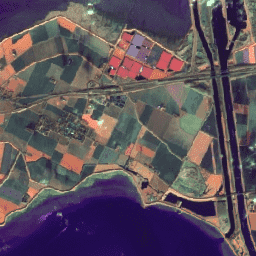
 /**
 * Function to mask clouds using the Sentinel-2 QA band
 * @param {ee.Image} image Sentinel-2 image
 * @return {ee.Image} cloud masked Sentinel-2 image
 */
 function

 maskS2clouds
 (
 image
 )

 {

 var

 qa

 =

 image
 .
 select
 (
 'QA60'
 );

 // Bits 10 and 11 are clouds and cirrus, respectively.

 var

 cloudBitMask

 =

 1
 <<
 10
 ;

 var

 cirrusBitMask

 =

 1
 <<
 11
 ;

 // Both flags should be set to zero, indicating clear conditions.

 var

 mask

 =

 qa
 .
 bitwiseAnd
 (
 cloudBitMask
 ).
 eq
 (
 0
 )

 .
 and
 (
 qa
 .
 bitwiseAnd
 (
 cirrusBitMask
 ).
 eq
 (
 0
 ));

 return

 image
 .
 updateMask
 (
 mask
 ).
 divide
 (
 10000
 );
 }
 // Map the function over a month of data and take the median.
 // Load Sentinel-2 TOA reflectance data (adjusted for processing changes
 // that occurred after 2022-01-25).
 var

 dataset

 =

 ee
 .
 ImageCollection
 (
 'COPERNICUS/S2_HARMONIZED'
 )

 .
 filterDate
 (
 '2022-01-01'
 ,

 '2022-01-31'
 )

 // Pre-filter to get less cloudy granules.

 .
 filter
 (
 ee
 .
 Filter
 .
 lt
 (
 'CLOUDY_PIXEL_PERCENTAGE'
 ,

 20
 ))

 .
 map
 (
 maskS2clouds
 );
 var

 rgbVis

 =

 {

 min
 :

 0.0
 ,

 max
 :

 0.3
 ,

 bands
 :

 [
 'B4'
 ,

 'B3'
 ,

 'B2'
 ],
 };
 Map
 .
 setCenter
 (
 -
 9.1695
 ,

 38.6917
 ,

 12
 );
 Map
 .
 addLayer
 (
 dataset
 .
 median
 (),

 rgbVis
 ,

 'RGB'
 );
 import

 ee
 import

 geemap.core

 as

 geemap
Colab (Python)
 def

 mask_s2_clouds
 (
 image
 ):

 """Masks clouds in a Sentinel-2 image using the QA band.
 Args:
 image (ee.Image): A Sentinel-2 image.
 Returns:
 ee.Image: A cloud-masked Sentinel-2 image.
 """
 qa
 =
 image
 .
 select
 (
 'QA60'
 )
 # Bits 10 and 11 are clouds and cirrus, respectively.
 cloud_bit_mask
 =
 1
<< 10
 cirrus_bit_mask
 =
 1
<< 11
 # Both flags should be set to zero, indicating clear conditions.
 mask
 =
 (
 qa
 .
 bitwiseAnd
 (
 cloud_bit_mask
 )
 .
 eq
 (
 0
 )
 .
 And
 (
 qa
 .
 bitwiseAnd
 (
 cirrus_bit_mask
 )
 .
 eq
 (
 0
 ))
 )
 return
 image
 .
 updateMask
 (
 mask
 )
 .
 divide
 (
 10000
 )
 dataset
 =
 (
 ee
 .
 ImageCollection
 (
 'COPERNICUS/S2_HARMONIZED'
 )
 .
 filterDate
 (
 '2022-01-01'
 ,
 '2022-01-31'
 )
 # Pre-filter to get less cloudy granules.
 .
 filter
 (
 ee
 .
 Filter
 .
 lt
 (
 'CLOUDY_PIXEL_PERCENTAGE'
 ,
 20
 ))
 .
 map
 (
 mask_s2_clouds
 )
 )
 rgb_vis
 =
 {
 'min'
 :
 0.0
 ,
 'max'
 :
 0.3
 ,
 'bands'
 :
 [
 'B4'
 ,
 'B3'
 ,
 'B2'
 ],
 }
 m
 =
 geemap
 .
 Map
 ()
 m
 .
 set_center
 (
 -
 9.1695
 ,
 38.6917
 ,
 12
 )
 m
 .
 add_layer
 (
 dataset
 .
 median
 (),
 rgb_vis
 ,
 'RGB'
 )
 m