
Page Summary
-
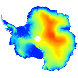
This dataset provides a digital elevation model (DEM) of the Antarctic ice sheet and ice shelves.
-
The DEM is based on observations from the CryoSat-2 satellite between July 2010 and July 2016.
-
The DEM is formed from fits to elevation measurements within 1, 2, and 5 km grid cells and is posted at a 1 km resolution.
-
The dataset includes bands for elevation, data composition method, slope, smoothed elevation, and elevation uncertainty.
-
The average accuracy of the DEM is estimated to be 9.5 meters.
- Dataset Availability
- 2010-07-01T00:00:00Z–2016-07-01T00:00:00Z
- Dataset Producer
- CPOM
- Tags
Description
This dataset is a digital elevation model (DEM) of the Antarctic ice sheet and ice shelves based on observations recorded by the CryoSat-2 satellite radar altimeter between July 2010 and July 2016.
The DEM is formed from spatio-temporal fits to elevation measurements accumulated within 1, 2, and 5 km grid cells, and is posted at the modal resolution of 1 km. The median and root mean square difference between the DEM and 2.3*10 7 ; airborne laser altimeter measurements acquired during NASA Operation IceBridge campaigns are -0.30 and 13.50 m, respectively.
The DEM uncertainty rises in regions of high slope, especially where elevation measurements were acquired in low-resolution mode; taking this into account, we estimate the average accuracy to be 9.5 m.
Bands
Bands
Pixel size: 1000 meters (all bands)
| Name | Units | Pixel Size | Description |
|---|---|---|---|
elevation
|
m | 1000 meters | Antarctic ice sheet and ice shelf elevation. |
data_composition
|
1000 meters | Data processing method of elevation per grid cell. |
|
slope
|
deg | 1000 meters | Slope derived from elevation gradient. |
z_smoothed
|
m | 1000 meters | Smoothed version of elevation model using a median filter. |
z_uncertainty
|
m | 1000 meters | Certainty of elevation model derived from RMS of elevation residuals in observed grid cells and the kriging variance error in interpolated grid cells. |
data_composition Class Table
| Value | Color | Description |
|---|---|---|
|
0
|
#000000 | interpolated |
|
1
|
#cbcbcb | 1 km fit |
|
2
|
#377eb7 | resampled 2 km fit |
|
3
|
#e2191b | resampled 5 km fit |
Terms of Use
Terms of Use
Citations
-
Slater, T., Shepherd, A., McMillan, M., Muir, A., Gilbert, L., Hogg, A. E., Konrad, H. and Parrinello, T.: A new Digital Elevation Model of Antarctica derived from CryoSat-2 altimetry, The Cryosphere, doi:10.5194/tc-2017-223 , 2018
DOIs
Explore with Earth Engine
Code Editor (JavaScript)
 var

 dataset

 =

 ee
 .
 Image
 (
 'CPOM/CryoSat2/ANTARCTICA_DEM'
 );
 var

 visualization

 =

 {

 bands
 :

 [
 'elevation'
 ],

 min
 :

 0.0
 ,

 max
 :

 4000.0
 ,

 palette
 :

 [
 '001fff'
 ,

 '00ffff'
 ,

 'fbff00'
 ,

 'ff0000'
 ]
 };
 Map
 .
 setCenter
 (
 17.0
 ,

 -
 76.0
 ,

 3
 );
 Map
 .
 addLayer
 (
 dataset
 ,

 visualization
 ,

 'Elevation'
 );