
AI-generated Key Takeaways
-
The Gridded Surface Meteorological dataset, provided by the University of California Merced, offers daily meteorological data at approximately 4-km resolution for the contiguous United States from 1979 to near present.
-
This dataset combines high-resolution spatial data with high-temporal resolution data to create continuous fields for various meteorological parameters including temperature, precipitation, winds, humidity, and radiation.
-
Provisional data products are available and are updated over time, progressing through 'early', 'provisional', and 'permanent' statuses.
-
The dataset includes various bands covering parameters like precipitation, humidity, specific humidity, radiation, wind speed and direction, temperature, fire danger indices, and evapotranspiration.
- Dataset Availability
- 1979-01-01T00:00:00Z–2025-11-14T06:00:00Z
- Dataset Provider
- University of California Merced
- Cadence
- 1 Day
- Tags
Description
The Gridded Surface Meteorological dataset provides high spatial resolution (~4-km) daily surface fields of temperature, precipitation, winds, humidity and radiation across the contiguous United States from 1979. The dataset blends the high resolution spatial data from PRISM with the high temporal resolution data from the National Land Data Assimilation System (NLDAS) to produce spatially and temporally continuous fields that lend themselves to additional land surface modeling.
This dataset contains provisional products that are replaced with updated versions when the complete source data become available. Products can be distinguished by the value of the 'status' property. At first, assets are ingested with status='early'. After several days, they are replaced by assets with status='provisional'. After about 2 months, they are replaced by the final assets with status='permanent'.
Bands
Pixel Size 4638.3 meters
Bands
| Name | Units | Min | Max | Pixel Size | Description |
|---|---|---|---|---|---|
pr
|
mm, daily total | 0* | 690.44* | meters | Precipitation amount |
rmax
|
% | 1.05* | 100* | meters | Maximum relative humidity |
rmin
|
% | 0* | 100* | meters | Minimum relative humidity |
sph
|
Mass fraction | 0* | 0.02* | meters | Specific humididy |
srad
|
W/m^2 | 0* | 455.61* | meters | Surface downward shortwave radiation |
th
|
deg | meters | Wind direction |
||
tmmn
|
K | 225.54* | 314.88* | meters | Minimum temperature |
tmmx
|
K | 233.08* | 327.14* | meters | Maximum temperature |
vs
|
m/s | 0.14* | 29.13* | meters | Wind velocity at 10m |
erc
|
NFDRS fire danger index | 0* | 131.85* | meters | Energy release component |
eto
|
mm | 0* | 17.27* | meters | Daily grass reference evapotranspiration |
bi
|
NFDRS fire danger index | 0* | 214.2* | meters | Burning index |
fm100
|
% | 0.28* | 33.2* | meters | 100-hour dead fuel moisture |
fm1000
|
% | 0.36* | 47.52* | meters | 1000-hour dead fuel moisture |
etr
|
mm | 0* | 27.02* | meters | Daily alfalfa reference evapotranspiration |
vpd
|
kPa | 0* | 9.83* | meters | Mean vapor pressure deficit |
Image Properties
Image Properties
| Name | Type | Description |
|---|---|---|
|
status
|
STRING | 'early', 'provisional', or 'permanent' |
Terms of Use
Terms of Use
This work (METDATA, by John Abatzoglou) is in the public domain and is free of known copyright restrictions. Users should properly cite the source used in the creation of any reports and publications resulting from the use of this dataset and note the date when the data was acquired.
Citations
-
Abatzoglou J. T., Development of gridded surface meteorological data for ecological applications and modelling, International Journal of Climatology. (2012) doi:10.1002/joc.3413
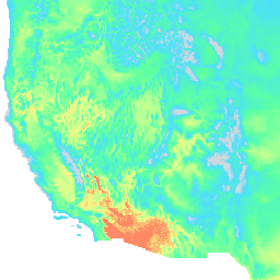
Explore with Earth Engine
Code Editor (JavaScript)
 var

 dataset

 =

 ee
 .
 ImageCollection
 (
 'IDAHO_EPSCOR/GRIDMET'
 )

 .
 filter
 (
 ee
 .
 Filter
 .
 date
 (
 '2018-08-01'
 ,

 '2018-08-15'
 ));
 var

 maximumTemperature

 =

 dataset
 .
 select
 (
 'tmmx'
 );
 var

 maximumTemperatureVis

 =

 {

 min
 :

 290.0
 ,

 max
 :

 314.0
 ,

 palette
 :

 [
 'd8d8d8'
 ,

 '4addff'
 ,

 '5affa3'
 ,

 'f2ff89'
 ,

 'ff725c'
 ],
 };
 Map
 .
 setCenter
 (
 -
 115.356
 ,

 38.686
 ,

 5
 );
 Map
 .
 addLayer
 (
 maximumTemperature
 ,

 maximumTemperatureVis
 ,

 'Maximum Temperature'
 );