
Page Summary
-
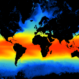
This dataset provides daily sea surface temperature data from 2018-01-01 to 2021-11-28, collected by the GCOM-C satellite's SGLI sensor.
-
The GCOM-C mission aims to monitor climate changes and improve predictions of future environmental conditions by observing radiation budget and carbon cycle fluctuations.
-
The SGLI sensor on GCOM-C is an imaging radiometer with 19 channels, capable of global observation approximately every two days with a resolution of 4638.3 meters and includes polarized and multi-angle observation functions.
-
The dataset includes sea surface temperature data (
SST_AVE) and quality assurance flags (SST_QA_flag) with detailed bitmask information. -
This dataset is free to use without restrictions, with the requirement to credit the Japan Aerospace Exploration Agency (JAXA).
- Dataset Availability
- 2018-01-01T00:00:00Z–2021-11-28T00:00:00Z
- Dataset Producer
- Global Change Observation Mission (GCOM)
- Cadence
- 1 Day
- Tags
Description
This product is the temperature of sea surface.
For data after 2021-11-28, see the V3 dataset .
GCOM-C conducts long-term and continuous global observation and data collection to elucidate the mechanism behind fluctuations in radiation budget and carbon cycle needed to make accurate projections regarding future temperature rise. At the same time, cooperating with research institutions having a climate numerical model, it contributes to reduction of errors in temperature rise prediction derived from the climate numerical model and improvement of accuracy of prediction of various environmental changes. SGLI mounted on GCOM-C is the succession sensor of the Global Imager (GLI) mounted on ADEOS-II (MIDORI II) and is the Imaging Radiometer which measures the radiation from near-ultraviolet to thermal infrared region (380 nm-12 um) in 19 channels. Global observation of once for approximately every two days is possible at mid-latitude near Japan by observation width at ground greater than 1,000 km. In addition, SGLI realizes high resolution than the similar global sensor and has a polarized observation function and a multi-angle observation function.
Bands
Bands
Pixel size: 4638.3 meters (all bands)
SST_AVE
Temperature of sea surface.
SST_QA_flag
SST QA
Image Properties
Image Properties
Algorithm version
Spatial resolution
Unit of GRID_INTERVAL
Image acquisition end time
Image acquisition start time
Good, Fair, Poor, NG
Processing time
Source filename
Product version
Satellite orbit direction
- A: Nighttime data
- D: Daytime data
Offset
Slope
Terms of Use
Terms of Use
This dataset is free to use without any restrictions (including commercial use). Anyone wishing to publish analyzed results or value added data products should properly credit the original G-Portal data, e.g., "PR data by Japan Aerospace Exploration Agency". For value added data products, please indicate the credit of the original G-Portal data, e.g., "Original data for this value added data product was provided by Japan Aerospace Exploration Agency."
See G-Portal's terms of service (Article 7) for additional information.
Citations
-
Kurihara, Y. (Jun. 2020). GCOM-C/SGLI Sea Surface Temperature (SST) ATBD (Version 2). Retrieved from https://suzaku.eorc.jaxa.jp/GCOM_C/data/ATBD/ver2/V2ATBD_O1AB_SST_Kurihara_r1.pdf
Explore with Earth Engine
Code Editor (JavaScript)
 var

 dataset

 =

 ee
 .
 ImageCollection
 (
 'JAXA/GCOM-C/L3/OCEAN/SST/V2'
 )

 .
 filterDate
 (
 '2020-01-01'
 ,

 '2020-02-01'
 )

 // filter to daytime data only

 .
 filter
 (
 ee
 .
 Filter
 .
 eq
 (
 'SATELLITE_DIRECTION'
 ,

 'D'
 ));
 // Multiply with slope coefficient and add offset
 var

 dataset

 =

 dataset
 .
 mean
 ().
 multiply
 (
 0.0012
 ).
 add
 (
 -
 10
 );
 var

 vis

 =

 {

 bands
 :

 [
 'SST_AVE'
 ],

 min
 :

 0
 ,

 max
 :

 30
 ,

 palette
 :

 [
 '000000'
 ,

 '005aff'
 ,

 '43c8c8'
 ,

 'fff700'
 ,

 'ff0000'
 ],
 };
 Map
 .
 setCenter
 (
 128.45
 ,

 33.33
 ,

 5
 );
 Map
 .
 addLayer
 (
 dataset
 ,

 vis
 ,

 'Sea Surface Temperature'
 );