
Page Summary
-
This dataset provides European crop type maps for 2018 and 2022 at a 10m resolution.
-
The maps are derived from Sentinel-1, Sentinel-2, and auxiliary data, along with LUCAS Copernicus in-situ observations.
-
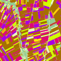
The dataset includes a classification band with specific values, colors, and descriptions for various crop types and land cover.
-
This dataset is available from 2018 to 2022 and is provided by the Joint Research Center (JRC).
- Dataset Availability
- 2018-01-01T00:00:00Z–2022-01-01T00:00:00Z
- Dataset Provider
- Joint Research Center (JRC)
- Cadence
- 1 Year
- Tags
Description
European crop type maps based on Sentinel-1 and LUCAS Copernicus 2018 in-situ observations for 2018, and a combination of Sentinel-1, Sentinel-2, and auxiliary data with LUCAS Copernicus 2022 observations for 2022.
Based on the unique LUCAS 2018 Copernicus in-situ survey , this dataset represents the first EU-scale crop type map at 10m resolution, which was derived exclusively from S1A and S1B synthetic aperture radar observations. The 2022 dataset continues this effort using a multi-source approach that combines Sentinel-1 and Sentinel-2 imagery with temperature and elevation data, supported by LUCAS 2022 observations.
Bands
Pixel Size 10 meters
Bands
| Name | Pixel Size | Description |
|---|---|---|
classification
|
meters | Main crop-specific land cover classification. |
classification Class Table
| Value | Color | Description |
|---|---|---|
|
100
|
#ff130f | Artificial |
|
211
|
#a57000 | Common wheat |
|
212
|
#896054 | Durum wheat |
|
213
|
#e2007c | Barley |
|
214
|
#aa007c | Rye |
|
215
|
#a05989 | Oats |
|
216
|
#ffd300 | Maize |
|
217
|
#00a8e2 | Rice |
|
218
|
#d69ebc | Triticale |
|
219
|
#d69ebc | Other cereals |
|
221
|
#dda50a | Potatoes |
|
222
|
#a800e2 | Sugar beet |
|
223
|
#00af49 | Other root crops |
|
230
|
#00af49 | Other non-permanent industrial crops |
|
231
|
#ffff00 | Sunflower |
|
232
|
#d1ff00 | Rapeseed and turnip rapeseed |
|
233
|
#267000 | Soya |
|
240
|
#f2a377 | Dry pulses |
|
250
|
#e8bfff | Fodder crops (cereals and leguminous) |
|
290
|
#696969 | Bare arable land |
|
300
|
#93cc93 | Woodland and Shrubland (incl. permanent crops) |
|
500
|
#e8ffbf | Grasslands |
|
600
|
#a89e7f | Bare land/lichens moss |
|
700
|
#0793de | Water |
|
800
|
#7cafaf | Wetlands |
Image Properties
Image Properties
| Name | Type | Description |
|---|---|---|
|
classification_class_names
|
STRING_LIST | Array of cropland classification names. |
|
classification_class_palette
|
STRING_LIST | Array of hex code color strings used for the classification palette. |
|
classification_class_values
|
INT_LIST | Value of the cropland classification. |
Terms of Use
Terms of Use
Citations
-
d'Andrimont, R., Verhegghen, A., Lemoine, G., Kempeneers, P., Meroni, M., & Van der Velde, M. (2021). From parcel to continental scale-A first European crop type map based on Sentinel-1 and LUCAS Copernicus in-situ observations. Remote sensing of environment, 266, 112708.
-
d'Andrimont, R., Verhegghen, A., Lemoine, G., Kempeneers, P., Meroni, M., & Van der Velde, M. (2021). From parcel to continental scale-A first European crop type map based on Sentinel-1 and LUCAS Copernicus in-situ observations. Remote sensing of environment, 266, 112708. doi:10.1016/j.rse.2021.112708 .
-
Ghassemi, B., Izquierdo-Verdiguier, E., Verhegghen, A., Yordanov, M., Lemoine, G., Moreno Martínez, Á., De Marchi, D., van der Velde, M., Vuolo, F. and d’Andrimont, R., 2024. European Union crop map 2022: Earth observation’s 10-meter dive into Europe’s crop tapestry. Scientific Data, 11(1), p.1048. 10.1038/s41597-024-03884-y
DOIs
Explore with Earth Engine
Code Editor (JavaScript)
 var

 image

 =

 ee
 .
 ImageCollection
 (
 'JRC/D5/EUCROPMAP/V1'
 ).
 filterDate
 (

 '2018-01-01'
 ,

 '2019-01-01'
 ).
 first
 ();
 Map
 .
 addLayer
 (
 image
 ,

 {},

 'EUCROPMAP 2018'
 );
 Map
 .
 setCenter
 (
 10
 ,

 48
 ,

 4
 );