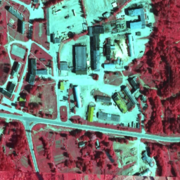
In Latvia, orthophoto maps are prepared in the Latvian coordinate system
LKS-92 TM according to the TKS-93 map sheet division (scale 1:10000 map
sheet corresponds to 5 x 5 kilometers in nature). Orthophoto maps are
prepared for the whole territory of Latvia at the scale of 1:10000, but for
separate territories - for cities and densely populated areas - at the scale
of 1:2000 or 1:1000.
The CIR dataset has three bands: Near-Infrared, Red, and Green.
In Latvia, orthophoto maps are prepared in the Latvian coordinate system LKS-92 TM according to the TKS-93 map sheet division (scale 1:10000 map sheet corresponds to 5 x 5 kilometers in nature). Orthophoto maps are prepared for the whole territory of Latvia at the scale of 1:10000, but for separate …
[[["Easy to understand","easyToUnderstand","thumb-up"],["Solved my problem","solvedMyProblem","thumb-up"],["Other","otherUp","thumb-up"]],[["Missing the information I need","missingTheInformationINeed","thumb-down"],["Too complicated / too many steps","tooComplicatedTooManySteps","thumb-down"],["Out of date","outOfDate","thumb-down"],["Samples / code issue","samplesCodeIssue","thumb-down"],["Other","otherDown","thumb-down"]],[],[[["\u003cp\u003eThis dataset provides Color InfraRed (CIR) orthophoto maps for Latvia from 2007 to 2018.\u003c/p\u003e\n"],["\u003cp\u003eThe orthophotos have a resolution of 0.2 meters and include Near-Infrared, Red, and Green bands.\u003c/p\u003e\n"],["\u003cp\u003eCoverage includes the entire territory of Latvia at a scale of 1:10,000, with some urban areas at scales of 1:2,000 or 1:1,000.\u003c/p\u003e\n"],["\u003cp\u003eThe dataset is provided by the Latvian Geospatial Information Agency and is available through Google Earth Engine.\u003c/p\u003e\n"],["\u003cp\u003eUsers should refer to the provided links for detailed terms of use and licensing information from the Latvian Geospatial Information Agency.\u003c/p\u003e\n"]]],["Orthophoto maps for Latvia, provided by the Latvian Geospatial Information Agency, are available from 2007 to 2018. The CIR dataset, accessible via Earth Engine using `ee.ImageCollection(\"Latvia/Maamet/orthos/cir\")`, includes Near-Infrared, Red, and Green bands, each with a pixel size of 0.2 meters and a value range of 0-255. Maps are primarily at 1:10000 scale, with larger scales for cities. Terms of use and documentation are available via provided links.\n"],null,["# Latvia Color InfraRed (CIR) orthophotos\n\nDataset Availability\n: 2007-01-01T00:00:00Z--2018-01-01T00:00:00Z\n\nDataset Provider\n:\n\n\n [Latvia orthophotos](https://www.lgia.gov.lv/lv/ortofotokartes-1)\n\nTags\n:\n[latvia](/earth-engine/datasets/tags/latvia) [nrg](/earth-engine/datasets/tags/nrg) [orthophotos](/earth-engine/datasets/tags/orthophotos) \n\n#### Description\n\nIn Latvia, orthophoto maps are prepared in the Latvian coordinate system\nLKS-92 TM according to the TKS-93 map sheet division (scale 1:10000 map\nsheet corresponds to 5 x 5 kilometers in nature). Orthophoto maps are\nprepared for the whole territory of Latvia at the scale of 1:10000, but for\nseparate territories - for cities and densely populated areas - at the scale\nof 1:2000 or 1:1000.\n\nThe CIR dataset has three bands: Near-Infrared, Red, and Green.\n\nFor more information, please see the\n[Latvia orthophotos documentation](https://www.lgia.gov.lv/lv/ortofotokartes-1)\n\n### Bands\n\n\n**Pixel Size**\n\n0.2 meters\n\n**Bands**\n\n| Name | Units | Min | Max | Pixel Size | Description |\n|------|-------|-----|-----|------------|---------------|\n| `N` | dn | 0 | 255 | meters | Near-Infrared |\n| `R` | dn | 0 | 255 | meters | Red |\n| `G` | dn | 0 | 255 | meters | Green |\n\n### Terms of Use\n\n**Terms of Use**\n\nFor more details please see the\n[Terms of use](https://www.lgia.gov.lv/sites/lgia/files/document/Atverto%20datu%20licence%20CC%20BY_0.pdf)\n\n### Citations\n\nCitations:\n\n- Latvijas Geospatial Information Agency\n\n### Explore with Earth Engine\n\n| **Important:** Earth Engine is a platform for petabyte-scale scientific analysis and visualization of geospatial datasets, both for public benefit and for business and government users. Earth Engine is free to use for research, education, and nonprofit use. To get started, please [register for Earth Engine access.](https://console.cloud.google.com/earth-engine)\n\n### Code Editor (JavaScript)\n\n```javascript\nvar dataset = ee.ImageCollection('Latvia/Maamet/orthos/cir');\n\nMap.setCenter(24.737, 56.861, 15);\nMap.addLayer(dataset, null, 'Latvia Maamet Color InfraRed (CIR)');\n```\n[Open in Code Editor](https://code.earthengine.google.com/?scriptPath=Examples:Datasets/Latvia/Latvia_Maamet_orthos_cir) \n[Latvia Color InfraRed (CIR) orthophotos](/earth-engine/datasets/catalog/Latvia_Maamet_orthos_cir) \nIn Latvia, orthophoto maps are prepared in the Latvian coordinate system LKS-92 TM according to the TKS-93 map sheet division (scale 1:10000 map sheet corresponds to 5 x 5 kilometers in nature). Orthophoto maps are prepared for the whole territory of Latvia at the scale of 1:10000, but for separate ... \nLatvia/Maamet/orthos/cir, latvia,nrg,orthophotos \n2007-01-01T00:00:00Z/2018-01-01T00:00:00Z \n55.5 20.5 58.5 28.6 \nGoogle Earth Engine \nhttps://developers.google.com/earth-engine/datasets\n\n- [](https://doi.org/https://www.lgia.gov.lv/lv/ortofotokartes-1)\n- [](https://doi.org/https://developers.google.com/earth-engine/datasets/catalog/Latvia_Maamet_orthos_cir)"]]