
Page Summary
-
The MOD44W V6 land/water mask 250m product provides a land-water mask derived using a decision tree classifier and validated with a previous version.
-
This dataset is available from 2000-01-01 to 2015-01-01 with a yearly cadence.
-
The dataset includes a water mask band and a quality assurance band.
-
MODIS data and products, including this one, have no restrictions on subsequent use, sale, or redistribution.
-
This dataset can be explored using Google Earth Engine for scientific analysis and visualization.
- Dataset Availability
- 2000-01-01T00:00:00Z–2015-01-01T00:00:00Z
- Dataset Producer
- NASA LP DAAC at the USGS EROS Center
- Cadence
- 1 Year
- Tags
Description
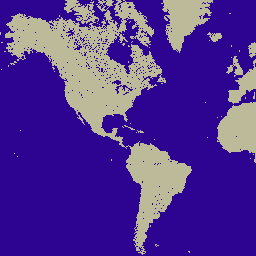
The MOD44W V6 land/water mask 250m product is derived using a decision tree classifier trained with MODIS data and validated with the MOD44W V5 product. A series of masks are applied to address known issues caused by terrain shadow, burn scars, cloudiness, or ice cover in oceans.
Bands
Bands
Pixel size: 250 meters (all bands)
water_mask
Land-water mask
water_mask_QA
Quality assurance (QA)
Terms of Use
Terms of Use
MODIS data and products acquired through the LP DAAC have no restrictions on subsequent use, sale, or redistribution.
Citations
-
Please visit LP DAAC 'Citing Our Data' page for information on citing LP DAAC datasets.
DOIs
Explore with Earth Engine
Code Editor (JavaScript)
 var

 dataset

 =

 ee
 .
 ImageCollection
 (
 'MODIS/006/MOD44W'
 )

 .
 filter
 (
 ee
 .
 Filter
 .
 date
 (
 '2015-01-01'
 ,

 '2015-05-01'
 ));
 var

 waterMask

 =

 dataset
 .
 select
 (
 'water_mask'
 );
 var

 waterMaskVis

 =

 {

 min
 :

 0
 ,

 max
 :

 1
 ,

 palette
 :

 [
 'bcba99'
 ,

 '2d0491'
 ],
 };
 Map
 .
 setCenter
 (
 6.746
 ,

 46.529
 ,

 2
 );
 Map
 .
 addLayer
 (
 waterMask
 ,

 waterMaskVis
 ,

 'Water Mask'
 );