
AI-generated Key Takeaways
-
The MCD12Q2 Version 6.1 data product provides global land surface phenology metrics yearly from 2001 to 2024.
-
This dataset offers vegetation phenology metrics at a 500-meter spatial resolution, identifying up to two growing cycles per year based on the Enhanced Vegetation Index (EVI2).
-
The data includes various bands detailing aspects of vegetation cycles, such as the onset and peak of greenness, dormancy, and quality information.
-
Data gaps due to cloud cover are filled using good quality data from the preceding or following year.
-
This dataset is derived from MODIS Terra and Aqua combined data and has no restrictions on subsequent use.
- Dataset Availability
- 2001-01-01T00:00:00Z–2024-01-01T00:00:00Z
- Dataset Provider
- NASA LP DAAC at the USGS EROS Center
- Cadence
- 1 Year
- Tags
Description
The Terra and Aqua combined Moderate Resolution Imaging Spectroradiometer (MODIS) Land Cover Dynamics (MCD12Q2) Version 6.1 data product provides global land surface phenology metrics at yearly intervals. The MCD12Q2 Version 6.1 data product is derived from time series of the 2-band Enhanced Vegetation Index (EVI2) calculated from MODIS Nadir Bidirectional Reflectance Distribution Function (BRDF)-Adjusted Reflectance(NBAR). Vegetation phenology metrics at 500 meter spatial resolution are identified for up to two detected growing cycles per year. For pixels with more than two valid vegetation cycles, the data represent the two cycles with the largest NBAR-EVI2 amplitudes.
Each asset contains bands are layers for the total number of vegetation cycles detected for the product year, the onset of greenness, greenup midpoint, maturity, peak greenness, senescence, greendown midpoint, dormancy, EVI2 minimum, EVI2 amplitude, integrated EVI2 over a vegetation cycle, as well as overall and phenology metric-specific quality information.
For areas where the NBAR-EVI2 values are missing due to cloud cover or other reasons, the data gaps are filled with good quality NBAR-EVI2 values from the year directly preceding or following the product year.
Bands
Pixel Size 500 meters
Bands
NumCycles
Total number of valid vegetation cycles with peak in product year
Greenup_1
Date when EVI2 first crossed 15% of the segment EVI2 amplitude, cycle 1. Days since Jan 1, 1970.
Greenup_2
Date when EVI2 first crossed 15% of the segment EVI2 amplitude, cycle 2. Days since Jan 1, 1970.
MidGreenup_1
Date when EVI2 first crossed 50% of the segment EVI2 amplitude, cycle 1. Days since Jan 1, 1970.
MidGreenup_2
Date when EVI2 first crossed 50% of the segment EVI2 amplitude, cycle 2. Days since Jan 1, 1970.
Peak_1
Date when EVI2 reached the segment maximum, cycle 1. Days since Jan 1, 1970.
Peak_2
Date when EVI2 reached the segment maximum, cycle 2. Days since Jan 1, 1970.
Maturity_1
Date when EVI2 first crossed 90% of the segment EVI2 amplitude, cycle 1. Days since Jan 1, 1970.
Maturity_2
Date when EVI2 first crossed 90% of the segment EVI2 amplitude, cycle 2. Days since Jan 1, 1970.
MidGreendown_1
Date when EVI2 last crossed 50% of the segment EVI2 amplitude, cycle 1. Days since Jan 1, 1970.
MidGreendown_2
Date when EVI2 last crossed 50% of the segment EVI2 amplitude, cycle 2. Days since Jan 1, 1970.
Senescence_1
Date when EVI2 last crossed 90% of the segment EVI2 amplitude, cycle 1. Days since Jan 1, 1970.
Senescence_2
Date when EVI2 last crossed 90% of the segment EVI2 amplitude, cycle 2. Days since Jan 1, 1970.
Dormancy_1
Date when EVI2 last crossed 15% of the segment EVI2 amplitude, cycle 1. Days since Jan 1, 1970.
Dormancy_2
Date when EVI2 last crossed 15% of the segment EVI2 amplitude, cycle 2. Days since Jan 1, 1970.
EVI_Minimum_1
Segment minimum EVI2 value, cycle 1
EVI_Minimum_2
Segment minimum EVI2 value, cycle 2
EVI_Amplitude_1
Segment maximum - minimum EVI2, cycle 1
EVI_Amplitude_2
Segment maximum - minimum EVI2, cycle 2
EVI_Area_1
Sum of daily interpolated EVI2 from Greenup to Dormancy, cycle 1
EVI_Area_2
Sum of daily interpolated EVI2 from Greenup to Dormancy, cycle 2
QA_Overall_1
QA code for entire segment, cycle 1
QA_Overall_2
QA code for entire segment, cycle 2
QA_Detailed_1
Bit-packed, SDS-specific QA codes, cycle 1
QA_Detailed_2
Bit-packed, SDS-specific QA codes, cycle 2
QA_Overall_1 Class Table
| Value | Color | Description |
|---|---|---|
|
0
|
None | Best |
|
1
|
None | Good |
|
2
|
None | Fair |
|
3
|
None | Poor |
QA_Overall_2 Class Table
| Value | Color | Description |
|---|---|---|
|
0
|
None | Best |
|
1
|
None | Good |
|
2
|
None | Fair |
|
3
|
None | Poor |
Terms of Use
Terms of Use
MODIS data and products acquired through the LP DAAC have no restrictions on subsequent use, sale, or redistribution.
Citations
-
Please visit LP DAAC 'Citing Our Data' page for information on citing LP DAAC datasets.
DOIs
Explore with Earth Engine
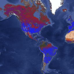
Code Editor (JavaScript)
 var

 dataset

 =

 ee
 .
 ImageCollection
 (
 'MODIS/061/MCD12Q2'
 )

 .
 filter
 (
 ee
 .
 Filter
 .
 date
 (
 '2001-01-01'
 ,

 '2002-01-01'
 ));
 var

 vegetationPeak

 =

 dataset
 .
 select
 (
 'Peak_1'
 );
 var

 vegetationPeakVis

 =

 {

 min
 :

 11400
 ,

 max
 :

 11868
 ,

 palette
 :

 [
 '0f17ff'
 ,

 'b11406'
 ,

 'f1ff23'
 ],
 };
 Map
 .
 setCenter
 (
 6.746
 ,

 46.529
 ,

 2
 );
 Map
 .
 addLayer
 (

 vegetationPeak
 ,

 vegetationPeakVis
 ,

 'Vegetation Peak 2001'
 );