
Page Summary
-
The MOD13A3 V6.1 product provides monthly vegetation index data at 1 kilometer spatial resolution from 2000 to 2025.
-
This dataset is used for global monitoring of vegetation conditions and can be input for modeling biogeochemical, hydrologic, and climate processes.
-
The dataset includes bands for NDVI, EVI, surface reflectance, and various quality assurance indicators.
-
MODIS data from LP DAAC have no restrictions on use, sale, or redistribution.
- Dataset Availability
- 2000-02-01T00:00:00Z–2026-05-01T00:00:00Z
- Dataset Producer
- NASA LP DAAC at the USGS EROS Center
- Cadence
- 1 Month
- Tags
Description
The MOD13A3 V6.1 product data is provided monthly at 1 kilometer (km) spatial resolution. In generating this monthly product, the algorithm ingests all the MOD13A2 products that overlap the month and employs a weighted temporal average.
Vegetation indices are used for global monitoring of vegetation conditions and are used in products displaying land cover and land cover changes. These data may be used as input for modeling global biogeochemical and hydrologic processes as well as global and regional climate. Additional applications include characterizing land surface biophysical properties and processes, such as primary production and land cover conversion.
Documentation:
Bands
Bands
Pixel size: 1000 meters (all bands)
NDVI
Monthly NDVI average
EVI
Monthly EVI average
DetailedQA
VI Quality indicators
sur_refl_b01
Surface reflectance band 1 (red)
sur_refl_b02
Surface reflectance band 2 (near-infrared)
sur_refl_b03
Surface reflectance band 3 (blue)
sur_refl_b07
Surface reflectance band 7 (mid-infrared)
ViewZenith
View zenith angle of VI Pixel
SolarZenith
Sun zenith angle of VI pixel
RelativeAzimuth
Relative azimuth angle of VI pixel
SummaryQA
Quality reliability of VI pixel
SummaryQA Class Table
| Value | Color | Description |
|---|---|---|
|
0
|
None | Good Data: use with confidence |
|
1
|
None | Marginal Data: useful, but look at other QA information |
|
2
|
None | Snow/Ice: target covered with snow/ice |
|
3
|
None | Cloudy: target not visible, covered with cloud |
Terms of Use
Terms of Use
MODIS data and products acquired through the LP DAAC have no restrictions on subsequent use, sale, or redistribution.
Citations
-
Please visit LP DAAC 'Citing Our Data' page for information on citing LP DAAC datasets.
DOIs
Explore with Earth Engine
Code Editor (JavaScript)
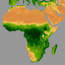
 var

 dataset

 =

 ee
 .
 ImageCollection
 (
 'MODIS/061/MOD13A3'
 )

 .
 filter
 (
 ee
 .
 Filter
 .
 date
 (
 '2020-01-01'
 ,

 '2023-05-01'
 ));
 var

 ndvi

 =

 dataset
 .
 select
 (
 'NDVI'
 );
 var

 ndviVis

 =

 {

 min
 :

 0
 ,

 max
 :

 9000
 ,

 palette
 :

 [

 'ffffff'
 ,

 'ce7e45'
 ,

 'df923d'
 ,

 'f1b555'
 ,

 'fcd163'
 ,

 '99b718'
 ,

 '74a901'
 ,

 '66a000'
 ,

 '529400'
 ,

 '3e8601'
 ,

 '207401'
 ,

 '056201'
 ,

 '004c00'
 ,

 '023b01'
 ,

 '012e01'
 ,

 '011d01'
 ,

 '011301'

 ],
 };
 Map
 .
 setCenter
 (
 6.746
 ,

 46.529
 ,

 2
 );
 Map
 .
 addLayer
 (
 ndvi
 ,

 ndviVis
 ,

 'NDVI'
 );