
Page Summary
-
The MYD13A2 V6.1 product provides both the Normalized Difference Vegetation Index (NDVI) and the Enhanced Vegetation Index (EVI).
-
Data is available from July 4, 2002, to September 22, 2025, with updates every 16 days.
-
The algorithm selects the best available pixel value over the 16-day period based on low clouds, low view angle, and highest NDVI/EVI.
-
The dataset includes various bands such as vegetation indices, quality indicators, surface reflectance bands, and view/solar angles.
-
MODIS data and products from LP DAAC have no restrictions on subsequent use, sale, or redistribution.
- Dataset Availability
- 2002-07-04T00:00:00Z–2026-05-17T00:00:00Z
- Dataset Producer
- NASA LP DAAC at the USGS EROS Center
- Cadence
- 16 Days
- Tags
Description
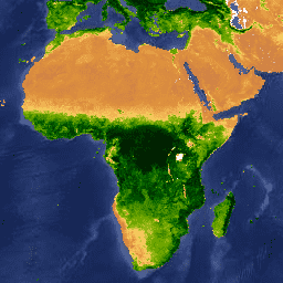
The MYD13A2 V6.1 product provides two Vegetation Indices (VI): the Normalized Difference Vegetation Index (NDVI) and the Enhanced Vegetation Index (EVI). The NDVI is referred to as the continuity index to the existing National Oceanic and Atmospheric Administration-Advanced Very High Resolution Radiometer (NOAA-AVHRR) derived NDVI. The EVI has improved sensitivity over high biomass regions.
The algorithm for this product chooses the best available pixel value from all the acquisitions from the 16-day period. The criteria used are low clouds, low view angle, and the highest NDVI/EVI value.
Documentation:
Bands
Bands
Pixel size: 1000 meters (all bands)
NDVI
16-day NDVI average
EVI
16-day EVI average
DetailedQA
VI Quality indicators
sur_refl_b01
Surface reflectance band 1 (red)
sur_refl_b02
Surface reflectance band 2 (near-infrared)
sur_refl_b03
Surface reflectance band 3 (blue)
sur_refl_b07
Surface reflectance band 7 (mid-infrared)
ViewZenith
View zenith angle of VI Pixel
SolarZenith
Sun zenith angle of VI pixel
RelativeAzimuth
Relative azimuth angle of VI pixel
DayOfYear
Day of year VI pixel
SummaryQA
Quality reliability of VI pixel
SummaryQA Class Table
| Value | Color | Description |
|---|---|---|
|
0
|
None | Good Data: use with confidence |
|
1
|
None | Marginal Data: useful, but look at other QA information |
|
2
|
None | Snow/Ice: target covered with snow/ice |
|
3
|
None | Cloudy: target not visible, covered with cloud |
Terms of Use
Terms of Use
MODIS data and products acquired through the LP DAAC have no restrictions on subsequent use, sale, or redistribution.
Citations
-
Please visit LP DAAC 'Citing Our Data' page for information on citing LP DAAC datasets.
DOIs
Explore with Earth Engine
Code Editor (JavaScript)
 var

 dataset

 =

 ee
 .
 ImageCollection
 (
 'MODIS/061/MYD13A2'
 )

 .
 filter
 (
 ee
 .
 Filter
 .
 date
 (
 '2018-01-01'
 ,

 '2018-05-01'
 ));
 var

 ndvi

 =

 dataset
 .
 select
 (
 'NDVI'
 );
 var

 ndviVis

 =

 {

 min
 :

 0
 ,

 max
 :

 9000
 ,

 palette
 :

 [

 'ffffff'
 ,

 'ce7e45'
 ,

 'df923d'
 ,

 'f1b555'
 ,

 'fcd163'
 ,

 '99b718'
 ,

 '74a901'
 ,

 '66a000'
 ,

 '529400'
 ,

 '3e8601'
 ,

 '207401'
 ,

 '056201'
 ,

 '004c00'
 ,

 '023b01'
 ,

 '012e01'
 ,

 '011d01'
 ,

 '011301'

 ],
 };
 Map
 .
 setCenter
 (
 6.746
 ,

 46.529
 ,

 2
 );
 Map
 .
 addLayer
 (
 ndvi
 ,

 ndviVis
 ,

 'NDVI'
 );