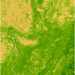
The Enhanced Vegetation Index (EVI) is generated from the
Near-IR, Red and Blue bands of each scene, and ranges in value from
-1.0 to 1.0. SeeHuete et al. (2002)for details. This product is generated from the MODIS/006/MCD43A4 surface reflectance composites.
Bands
Bands
Name
Pixel Size
Description
EVI
463.313 meters
Enhanced Vegetation Index
Terms of Use
Terms of Use
MODIS data and products acquired through the LP DAAC have no restrictions on subsequent use, sale, or redistribution.
The Enhanced Vegetation Index (EVI) is generated from the Near-IR, Red and Blue bands of each scene, and ranges in value from -1.0 to 1.0. See Huete et al. (2002) for details. This product is generated from the MODIS/006/MCD43A4 surface reflectance composites.
[[["Easy to understand","easyToUnderstand","thumb-up"],["Solved my problem","solvedMyProblem","thumb-up"],["Other","otherUp","thumb-up"]],[["Missing the information I need","missingTheInformationINeed","thumb-down"],["Too complicated / too many steps","tooComplicatedTooManySteps","thumb-down"],["Out of date","outOfDate","thumb-down"],["Samples / code issue","samplesCodeIssue","thumb-down"],["Other","otherDown","thumb-down"]],[],[[["\u003cp\u003eThe MODIS/MCD43A4_006_EVI dataset provides daily global Enhanced Vegetation Index (EVI) data derived from MODIS surface reflectance composites.\u003c/p\u003e\n"],["\u003cp\u003eEVI values range from -1.0 to 1.0 and are calculated using the Near-IR, Red, and Blue bands.\u003c/p\u003e\n"],["\u003cp\u003eThis dataset is available from February 24, 2000, to February 10, 2023, and is provided by Google Earth Engine.\u003c/p\u003e\n"],["\u003cp\u003eThe data is freely available for use, redistribution, and sale with no restrictions.\u003c/p\u003e\n"],["\u003cp\u003eEarth Engine offers tools and resources to explore and analyze this dataset, including a code editor and visualization capabilities.\u003c/p\u003e\n"]]],["The dataset, MODIS/MCD43A4_006_EVI, provided by Google, offers the Enhanced Vegetation Index (EVI) from 2000-02-24 to 2023-02-10 with a 1-day cadence. EVI, calculated from Near-IR, Red, and Blue bands, ranges from -1.0 to 1.0, at a pixel size of 463.313 meters. Users can access and explore this data through Google Earth Engine, which requires registration for use. The MODIS data has no restrictions for use, sale, or redistribution.\n"],null,["# MODIS Combined 16-Day EVI\n\nDataset Availability\n: 2000-02-24T00:00:00Z--2023-02-10T00:00:00Z\n\nDataset Provider\n:\n\n\n [Google](https://earthengine.google.com/)\n\nCadence\n: 1 Day\n\nTags\n:\n albedo \n brdf \n daily \n evi \n global \n mcd43a4 \n modis \n nasa \n reflectance \n usgs \nvegetation-indices \n\n#### Description\n\nThe Enhanced Vegetation Index (EVI) is generated from the\nNear-IR, Red and Blue bands of each scene, and ranges in value from\n-1.0 to 1.0. See\n[Huete et al. (2002)](https://www.sciencedirect.com/science/article/pii/S0034425702000962)\nfor details. This product is generated from the MODIS/006/MCD43A4 surface reflectance composites.\n\n### Bands\n\n**Bands**\n\n| Name | Pixel Size | Description |\n|-------|----------------|---------------------------|\n| `EVI` | 463.313 meters | Enhanced Vegetation Index |\n\n### Terms of Use\n\n**Terms of Use**\n\nMODIS data and products acquired through the LP DAAC have no restrictions on subsequent use, sale, or redistribution.\n\n### Explore with Earth Engine\n\n| **Important:** Earth Engine is a platform for petabyte-scale scientific analysis and visualization of geospatial datasets, both for public benefit and for business and government users. Earth Engine is free to use for research, education, and nonprofit use. To get started, please [register for Earth Engine access.](https://console.cloud.google.com/earth-engine)\n\n### Code Editor (JavaScript)\n\n```javascript\nvar dataset = ee.ImageCollection('MODIS/MCD43A4_006_EVI')\n .filter(ee.Filter.date('2018-04-01', '2018-06-01'));\nvar colorized = dataset.select('EVI');\nvar colorizedVis = {\n min: 0,\n max: 1,\n palette: [\n 'ffffff', 'ce7e45', 'df923d', 'f1b555', 'fcd163', '99b718', '74a901',\n '66a000', '529400', '3e8601', '207401', '056201', '004c00', '023b01',\n '012e01', '011d01', '011301'\n ],\n};\nMap.setCenter(-7.03125, 31.0529339857, 2);\nMap.addLayer(colorized, colorizedVis, 'Colorized');\n```\n[Open in Code Editor](https://code.earthengine.google.com/?scriptPath=Examples:Datasets/MODIS/MODIS_MCD43A4_006_EVI) \n[MODIS Combined 16-Day EVI](/earth-engine/datasets/catalog/MODIS_MCD43A4_006_EVI) \nThe Enhanced Vegetation Index (EVI) is generated from the Near-IR, Red and Blue bands of each scene, and ranges in value from -1.0 to 1.0. See Huete et al. (2002) for details. This product is generated from the MODIS/006/MCD43A4 surface reflectance composites. \nMODIS/MCD43A4_006_EVI, albedo,brdf,daily,evi,global,mcd43a4,modis,nasa,reflectance,usgs,vegetation-indices \n2000-02-24T00:00:00Z/2023-02-10T00:00:00Z \n-90 -180 90 180 \nGoogle Earth Engine \nhttps://developers.google.com/earth-engine/datasets\n\n- [](https://doi.org/https://earthengine.google.com/)\n- [](https://doi.org/https://developers.google.com/earth-engine/datasets/catalog/MODIS_MCD43A4_006_EVI)"]]