
Page Summary
-
This dataset contains Level 3 ocean color and satellite ocean biology data from MODIS-Aqua, available daily from July 3, 2002, to February 28, 2022.
-
Provided by NASA OB.DAAC at NASA Goddard Space Flight Center, this data is suitable for studying coastal biology and hydrology, marine habitat changes, biogeochemical fluxes, and the impact of climate change on ocean ecosystems.
-
The dataset includes bands for chlorophyll-a, normalized fluorescence line height, particulate organic carbon, remote sensing reflectance at various wavelengths, and sea surface temperature, with a pixel size of 4616 meters.
-
This dataset is in the public domain and can be freely used and distributed.
- Dataset Availability
- 2002-07-03T23:40:05Z–2022-02-28T00:20:00Z
- Dataset Producer
- NASA OB.DAAC at NASA Goddard Space Flight Center
- Cadence
- 1 Day
- Tags
Description
This level 3 product includes ocean color and satellite ocean biology data produced or collected under EOSDIS .
This dataset may be used for studying the biology and hydrology of coastal zones, changes in the diversity and geographical distribution of coastal marine habitats, biogeochemical fluxes and their influence in Earth's oceans and climate over time, and finally the impact of climate and environmental variability and change on ocean ecosystems and the biodiversity they support.
Scale factor and offset are already applied.
Documentation:
-
Algorithm Theoretical Basis Document (Fluorescence Line Height)
-
Algorithm Theoretical Basis Document (Particulate Organic Carbon)
-
Algorithm Theoretical Basis Document (Remote-Sensing Reflectance)
Newer datasets have scaled POC values while older ones don't. This scaling gets rid of negative values but older datasets still retain them hence the -2147.48 estimated minimum value. For more information, visit the Ocean Color Forum .
Bands
Bands
Pixel size: 4616 meters (all bands)
| Name | Units | Min | Max | Pixel Size | Wavelength | Description |
|---|---|---|---|---|---|---|
chlor_a
|
mg/m^3 | 0* | 99.99* | 4616 meters | None | Chlorophyll a concentration |
nflh
|
mW cm-2 μm-1 sr-1 | -0.5* | 5.03* | 4616 meters | None | Normalized fluorescence line height |
poc
|
mg/m^3 | -2147.48* | 12953.4* | 4616 meters | None | Particulate organic carbon |
Rrs_412
|
sr-1 | 0* | 0.11* | 4616 meters | 412nm | Remote sensing reflectance at band 412nm |
Rrs_443
|
sr-1 | 0* | 0.08* | 4616 meters | 443nm | Remote sensing reflectance at band 443nm |
Rrs_469
|
sr-1 | 0* | 0.08* | 4616 meters | 469nm | Remote sensing reflectance at band 469nm |
Rrs_488
|
sr-1 | 0* | 0.08* | 4616 meters | 488nm | Remote sensing reflectance at band 488nm |
Rrs_531
|
sr-1 | 0* | 0.07* | 4616 meters | 531nm | Remote sensing reflectance at band 531nm |
Rrs_547
|
sr-1 | 0* | 0.07* | 4616 meters | 547nm | Remote sensing reflectance at band 547nm |
Rrs_555
|
sr-1 | 0* | 0.07* | 4616 meters | 555nm | Remote sensing reflectance at band 555nm |
Rrs_645
|
sr-1 | 0* | 0.05* | 4616 meters | 645nm | Remote sensing reflectance at band 645nm |
Rrs_667
|
sr-1 | 0* | 0.04* | 4616 meters | 667nm | Remote sensing reflectance at band 667nm |
Rrs_678
|
sr-1 | 0* | 0.04* | 4616 meters | 678nm | Remote sensing reflectance at band 678nm |
sst
|
°C | -2* | 40* | 4616 meters | None | Sea surface temperature |
Image Properties
Image Properties
| Name | Type | Description |
|---|---|---|
|
Rrs_412_lastModified
|
STRING | Last date this product was modified |
|
Rrs_412_software_name
|
STRING | 'smigen' or 'l3mapgen'; name of the software used to create this product |
|
Rrs_412_software_version
|
STRING | Version of the software used to create this product |
|
Rrs_443_lastModified
|
STRING | Last date this product was modified |
|
Rrs_443_software_name
|
STRING | 'smigen' or 'l3mapgen'; name of the software used to create this product |
|
Rrs_443_software_version
|
STRING | Version of the software used to create this product |
|
Rrs_555_lastModified
|
STRING | Last date this product was modified |
|
Rrs_555_software_name
|
STRING | 'smigen' or 'l3mapgen'; name of the software used to create this product |
|
Rrs_555_software_version
|
STRING | Version of the software used to create this product |
|
chlor_a_lastModified
|
STRING | Last date this product was modified |
|
chlor_a_software_name
|
STRING | 'smigen' or 'l3mapgen'; name of the software used to create this product |
|
chlor_a_software_version
|
STRING | Version of the software used to create this product |
|
poc_lastModified
|
STRING | Last date this product was modified |
|
poc_software_name
|
STRING | 'smigen' or 'l3mapgen'; name of the software used to create this product |
|
poc_software_version
|
STRING | Version of the software used to create this product |
|
Rrs_469_lastModified
|
STRING | Last date this product was modified |
|
Rrs_469_software_name
|
STRING | 'smigen' or 'l3mapgen'; name of the software used to create this product |
|
Rrs_469_software_version
|
STRING | Version of the software used to create this product |
|
Rrs_488_lastModified
|
STRING | Last date this product was modified |
|
Rrs_488_software_name
|
STRING | 'smigen' or 'l3mapgen'; name of the software used to create this product |
|
Rrs_488_software_version
|
STRING | Version of the software used to create this product |
|
Rrs_531_lastModified
|
STRING | Last date this product was modified |
|
Rrs_531_software_name
|
STRING | 'smigen' or 'l3mapgen'; name of the software used to create this product |
|
Rrs_531_software_version
|
STRING | Version of the software used to create this product |
|
Rrs_547_lastModified
|
STRING | Last date this product was modified |
|
Rrs_547_software_name
|
STRING | 'smigen' or 'l3mapgen'; name of the software used to create this product |
|
Rrs_547_software_version
|
STRING | Version of the software used to create this product |
|
Rrs_645_lastModified
|
STRING | Last date this product was modified |
|
Rrs_645_software_name
|
STRING | 'smigen' or 'l3mapgen'; name of the software used to create this product |
|
Rrs_645_software_version
|
STRING | Version of the software used to create this product |
|
Rrs_667_lastModified
|
STRING | Last date this product was modified |
|
Rrs_667_software_name
|
STRING | 'smigen' or 'l3mapgen'; name of the software used to create this product |
|
Rrs_667_software_version
|
STRING | Version of the software used to create this product |
|
Rrs_678_lastModified
|
STRING | Last date this product was modified |
|
Rrs_678_software_name
|
STRING | 'smigen' or 'l3mapgen'; name of the software used to create this product |
|
Rrs_678_software_version
|
STRING | Version of the software used to create this product |
|
nflh_lastModified
|
STRING | Last date this product was modified |
|
nflh_software_name
|
STRING | 'smigen' or 'l3mapgen'; name of the software used to create this product |
|
nflh_software_version
|
STRING | Version of the software used to create this product |
|
sst_lastModified
|
STRING | Last date this product was modified |
|
sst_software_name
|
STRING | 'smigen' or 'l3mapgen'; name of the software used to create this product |
|
sst_software_version
|
STRING | Version of the software used to create this product |
Terms of Use
Terms of Use
This dataset is in the public domain and is available without restriction on use and distribution. See NASA's Earth Science Data & Information Policy for additional information.
Citations
-
NASA Goddard Space Flight Center, Ocean Ecology Laboratory, Ocean Biology Processing Group. Moderate-resolution Imaging Spectroradiometer (MODIS) Aqua Ocean Color Data, NASA OB.DAAC, Greenbelt, MD, USA.
- DOI: 10.5067/AQUA/MODIS/L3M/CHL/2018 [unrecoverable]
-
NASA Ocean Biology Processing Group. (2017). MODIS-Aqua Level 3 Mapped Fluorescent Line Height Data Version R2018.0 [Data set]. NASA Ocean Biology DAAC.
- DOI: 10.5067/AQUA/MODIS/L3M/FLH/2018 [unrecoverable]
-
NASA Ocean Biology Processing Group. (2017). MODIS-Aqua Level 3 Mapped Particulate Organic Carbon Data Version R2018.0 [Data set]. NASA Ocean Biology DAAC.
- DOI: 10.5067/AQUA/MODIS/L3M/POC/2018 [unrecoverable]
-
NASA Ocean Biology Processing Group. (2017). MODIS-Aqua Level 3 Mapped Remote-Sensing Reflectance Data Version R2018.0 [Data set]. NASA Ocean Biology DAAC.
- DOI: 10.5067/AQUA/MODIS/L3M/RRS/2018 [unrecoverable]
-
NASA/JPL. (2020). GHRSST Level 2P Global Sea Surface Skin Temperature from the Moderate Resolution Imaging Spectroradiometer (MODIS) on the NASA Aqua satellite (GDS2) [Data set]. NASA Physical Oceanography DAAC.
DOIs
Explore with Earth Engine
Code Editor (JavaScript)
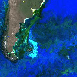
 var

 dataset

 =

 ee
 .
 ImageCollection
 (
 'NASA/OCEANDATA/MODIS-Aqua/L3SMI'
 )

 .
 filterDate
 (
 '2016-01-01'
 ,

 '2016-01-31'
 );
 var

 remoteSensingReflectance

 =

 dataset
 .
 select
 ([
 'Rrs_645'
 ,

 'Rrs_555'
 ,

 'Rrs_443'
 ]);
 var

 remoteSensingReflectanceVis

 =

 {

 min
 :

 0.0
 ,

 max
 :

 0.011
 ,
 };
 Map
 .
 setCenter
 (
 -
 52.12
 ,

 -
 46.13
 ,

 4
 );
 Map
 .
 addLayer
 (

 remoteSensingReflectance
 ,

 remoteSensingReflectanceVis
 ,

 'Remote Sensing Reflectance'
 );
 import

 ee
 import

 geemap.core

 as

 geemap
Colab (Python)
 dataset
 =
 ee
 .
 ImageCollection
 (
 'NASA/OCEANDATA/MODIS-Aqua/L3SMI'
 )
 .
 filterDate
 (
 '2016-01-01'
 ,
 '2016-01-31'
 )
 remote_sensing_reflectance
 =
 dataset
 .
 select
 ([
 'Rrs_645'
 ,
 'Rrs_555'
 ,
 'Rrs_443'
 ])
 remote_sensing_reflectance_vis
 =
 {
 'min'
 :
 0.0
 ,
 'max'
 :
 0.011
 }
 m
 =
 geemap
 .
 Map
 ()
 m
 .
 set_center
 (
 -
 52.12
 ,
 -
 46.13
 ,
 4
 )
 m
 .
 add_layer
 (
 remote_sensing_reflectance
 ,
 remote_sensing_reflectance_vis
 ,
 'Remote Sensing Reflectance'
 ,
 )
 m