
Page Summary
-
This dataset, available from 1997-09-04 to 2010-12-10, provides daily ocean color and satellite ocean biology data collected under EOSDIS by NASA OB.DAAC.
-
The dataset is suitable for studying coastal zones, marine habitats, biogeochemical fluxes, and the impact of climate change on ocean ecosystems.
-
Key bands in this dataset include chlorophyll a concentration, particulate organic carbon, and remote sensing reflectance at various wavelengths.
-
The data is in the public domain with no restrictions on use and distribution, and is available through Google Earth Engine for research, education, and non-profit use.
- Dataset Availability
- 1997-09-04T15:26:33Z–2010-12-10T19:42:17Z
- Dataset Producer
- NASA OB.DAAC at NASA Goddard Space Flight Center
- Cadence
- 1 Day
- Tags
Description
This level 3 product includes ocean color and satellite ocean biology data produced or collected under EOSDIS .
This dataset may be used for studying the biology and hydrology of coastal zones, changes in the diversity and geographical distribution of coastal marine habitats, biogeochemical fluxes and their influence in Earth's oceans and climate over time, and finally the impact of climate and environmental variability and change on ocean ecosystems and the biodiversity they support.
Scale factor and offset are already applied.
Documentation:
-
Algorithm Theoretical Basis Document (Fluorescence Line Height)
-
Algorithm Theoretical Basis Document (Particulate Organic Carbon)
-
Algorithm Theoretical Basis Document (Remote-Sensing Reflectance)
-
There are number of missing data dates in this dataset. For example, most dates are missing between 2009-04-29 and 2009-12-01.
-
The estimated values for POC might be a result of the data being generated without a scale. For more information, visit the SeaWiFS OceanData
Bands
Bands
Pixel size: 9200 meters (all bands)
| Name | Units | Min | Max | Pixel Size | Wavelength | Description |
|---|---|---|---|---|---|---|
chlor_a
|
mg/m^3 | 0* | 99.99* | 9200 meters | None | Chlorophyll a concentration |
poc
|
mg/m^3 | 9200 meters | None | Particulate organic carbon |
||
Rrs_412
|
sr-1 | 0* | 0.11* | 9200 meters | 412nm | Remote sensing reflectance at band 412nm |
Rrs_443
|
sr-1 | 0* | 0.11* | 9200 meters | 443nm | Remote sensing reflectance at band 443nm |
Rrs_490
|
sr-1 | 0* | 0.11* | 9200 meters | 490nm | Remote sensing reflectance at band 469nm |
Rrs_510
|
sr-1 | 0* | 0.11* | 9200 meters | 510nm | Remote sensing reflectance at band 488nm |
Rrs_555
|
sr-1 | 0* | 0.11* | 9200 meters | 555nm | Remote sensing reflectance at band 555nm |
Rrs_670
|
sr-1 | 0* | 0.11* | 9200 meters | 670nm | Remote sensing reflectance at band 531nm |
Image Properties
Image Properties
| Name | Type | Description |
|---|---|---|
|
Rrs_412_lastModified
|
STRING | Last date this product was modified |
|
Rrs_412_software_name
|
STRING | 'smigen' or 'l3mapgen'; name of the software used to create this product |
|
Rrs_412_software_version
|
STRING | Version of the software used to create this product |
|
Rrs_443_lastModified
|
STRING | Last date this product was modified |
|
Rrs_443_software_name
|
STRING | 'smigen' or 'l3mapgen'; name of the software used to create this product |
|
Rrs_443_software_version
|
STRING | Version of the software used to create this product |
|
Rrs_555_lastModified
|
STRING | Last date this product was modified |
|
Rrs_555_software_name
|
STRING | 'smigen' or 'l3mapgen'; name of the software used to create this product |
|
Rrs_555_software_version
|
STRING | Version of the software used to create this product |
|
chlor_a_lastModified
|
STRING | Last date this product was modified |
|
chlor_a_software_name
|
STRING | 'smigen' or 'l3mapgen'; name of the software used to create this product |
|
chlor_a_software_version
|
STRING | Version of the software used to create this product |
|
poc_lastModified
|
STRING | Last date this product was modified |
|
poc_software_name
|
STRING | 'smigen' or 'l3mapgen'; name of the software used to create this product |
|
poc_software_version
|
STRING | Version of the software used to create this product |
|
Rrs_490_lastModified
|
STRING | Last date this product was modified |
|
Rrs_490_software_name
|
STRING | 'smigen' or 'l3mapgen'; name of the software used to create this product |
|
Rrs_490_software_version
|
STRING | Version of the software used to create this product |
|
Rrs_510_lastModified
|
STRING | Last date this product was modified |
|
Rrs_510_software_name
|
STRING | 'smigen' or 'l3mapgen'; name of the software used to create this product |
|
Rrs_510_software_version
|
STRING | Version of the software used to create this product |
|
Rrs_670_lastModified
|
STRING | Last date this product was modified |
|
Rrs_670_software_name
|
STRING | 'smigen' or 'l3mapgen'; name of the software used to create this product |
|
Rrs_670_software_version
|
STRING | Version of the software used to create this product |
Terms of Use
Terms of Use
This dataset is in the public domain and is available without restriction on use and distribution. See NASA's Earth Science Data & Information Policy for additional information.
Citations
-
NASA Goddard Space Flight Center, Ocean Ecology Laboratory, Ocean Biology Processing Group. Sea-viewing Wide Field-of-view Sensor (SeaWiFS) Level 3 Binned Chlorophyll Data, NASA OB.DAAC, Greenbelt, MD, USA. SeaWiFS-ORBVIEW-2 Citations The old DOI for this publication was 10.5067/ORBVIEW-2/SEAWIFS/L3B/CHL/2018.0.
-
NASA Goddard Space Flight Center, Ocean Ecology Laboratory, Ocean Biology Processing Group. Sea-viewing Wide Field-of-view Sensor (SeaWiFS) Level 3 Binned Particulate Organic Carbon Data, NASA OB.DAAC, Greenbelt, MD, USA. The old DOI for this publication was 10.5067/ORBVIEW-2/SEAWIFS/L3B/POC/2018.0.
-
NASA Goddard Space Flight Center, Ocean Ecology Laboratory, Ocean Biology Processing Group. Sea-viewing Wide Field-of-view Sensor (SeaWiFS) Remote-Sensing Reflectance Data, NASA OB.DAAC, Greenbelt, MD, USA. The old DOI for this publication was 10.5067/ORBVIEW-2/SEAWIFS/L3B/RRS/2018.0.
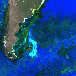
Explore with Earth Engine
Code Editor (JavaScript)
 var

 dataset

 =

 ee
 .
 ImageCollection
 (
 'NASA/OCEANDATA/SeaWiFS/L3SMI'
 )

 .
 filter
 (
 ee
 .
 Filter
 .
 date
 (
 '2009-07-01'
 ,

 '2009-08-30'
 ));
 var

 remoteSensingReflectance

 =

 dataset
 .
 select
 ([
 'Rrs_670'
 ,

 'Rrs_555'
 ,

 'Rrs_443'
 ]);
 var

 remoteSensingReflectanceVis

 =

 {

 min
 :

 0.0
 ,

 max
 :

 0.03
 ,
 };
 Map
 .
 setCenter
 (
 -
 52.12
 ,

 -
 46.13
 ,

 1
 );
 Map
 .
 addLayer
 (

 remoteSensingReflectance
 ,

 remoteSensingReflectanceVis
 ,

 'Remote Sensing Reflectance'
 );