
Page Summary
-
The VIIRS VNP46A2 dataset provides daily global measurements of nocturnal visible and near-infrared light.
-
This dataset offers improvements in sensor resolution and calibration compared to previous nighttime lights products.
-
VNP46A2 is a daily moonlight- and atmosphere-corrected Nighttime Lights product with a 500m pixel size.
-
The dataset includes several bands such as corrected and gap-filled nighttime light, lunar irradiance, and various quality flags.
- Dataset Availability
- 2012-01-19T00:00:00Z–2026-05-31T00:00:00Z
- Dataset Producer
- NASA LAADS DAAC
- Cadence
- 1 Day
- Tags
Description
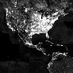
The Suomi National Polar-orbiting Partnership (SNPP) Visible Infrared Imaging Radiometer Suite (VIIRS) supports a Day-Night Band (DNB) sensor that provides global daily measurements of nocturnal visible and near-infrared(NIR) light that are suitable for Earth system science and applications. The VIIRS DNB's ultra-sensitivity in lowlight conditions enable us to generate a new set of science-quality nighttime products that manifest substantial improvements in sensor resolution and calibration when compared to the previous era of Defense Meteorological Satellite Program/Operational Linescan System's (DMSP/OLS) nighttime lights image products. Such improvements allow the VIIRS DNB products to better monitor both the magnitude and signature of nighttime phenomena, and anthropogenic sources of light emissions.
VNP46A2 is the short-name for the daily moonlight- and atmosphere-corrected Nighttime Lights (NTL) product called VIIRS/NPP Gap-Filled Lunar BRDF-Adjusted Nighttime Lights Daily L3 Global 500m Linear Lat Lon Grid.
Documentation:
Bands
Bands
Pixel size: 500 meters (all bands)
DNB_BRDF_Corrected_NTL
BRDF corrected DNB NTL
Gap_Filled_DNB_BRDF_Corrected_NTL
Gap Filled BRDF corrected DNB NTL
DNB_Lunar_Irradiance
DNB Lunar Irradiance
Latest_High_Quality_Retrieval
Latest high quality BRDF corrected DNB radiance retrieval
Mandatory_Quality_Flag
Mandatory quality flag
Snow_Flag
Flag for snow cover
QF_Cloud_Mask
Quality flag for cloud mask
Mandatory_Quality_Flag Class Table
| Value | Color | Description |
|---|---|---|
|
0
|
None | High-quality, Persistent nighttime lights |
|
1
|
None | High-quality, Ephemeral nighttime Lights |
|
2
|
None | Poor-quality, Outlier, potential cloud contamination, or other issues |
|
255
|
None | No retrieval, Fill value (masked out on ingestion) |
Snow_Flag Class Table
| Value | Color | Description |
|---|---|---|
|
0
|
None | No Snow/Ice |
|
1
|
None | Snow/Ice |
Terms of Use
Terms of Use
LP DAAC NASA data are freely accessible; however, when an author publishes these data or works based on the data, it is requested that the author cite the datasets within the text of the publication and include a reference to them in the reference list.
Citations
-
Román, M.O., Wang, Z., Sun, Q., Kalb, V., Miller, S.D., Molthan, A., Schultz, L., Bell, J., Stokes, E.C., Pandey, B. and Seto, K.C., et al. (2018). NASA's Black Marble nighttime lights product suite. Remote Sensing of Environment 210, 113-143. 10.1016/j.rse.2018.03.017
DOIs
Explore with Earth Engine
Code Editor (JavaScript)
 var

 dataset

 =

 ee
 .
 ImageCollection
 (
 'NASA/VIIRS/002/VNP46A2'
 )

 .
 filter
 (
 ee
 .
 Filter
 .
 date
 (
 '2013-01-01'
 ,

 '2013-03-01'
 ));
 var

 nighttime

 =

 dataset
 .
 select
 (
 'Gap_Filled_DNB_BRDF_Corrected_NTL'
 );
 var

 nighttimeVis

 =

 {
 min
 :

 0.0
 ,

 max
 :

 1.0
 };
 Map
 .
 setCenter
 (
 -
 77.1056
 ,

 38.8904
 ,

 3
 );
 Map
 .
 addLayer
 (
 nighttime
 ,

 nighttimeVis
 ,

 'Nighttime'
 );