
Page Summary
-
This dataset offers high-quality Climate Data Records (CDR) of cloud properties, brightness temperatures, and reflectances derived from AVHRR PATMOS-x.
-
The data, available daily from 1979 to 2022, is gridded to a 0.1 x 0.1 equal angle grid.
-
The dataset includes 48 bands, with 11 designated as CDR quality variables.
-
Cloud products are generated using the ACHA and DCOMP algorithms, with detailed documentation available.
-
The data is nonproprietary and publicly available for use without restrictions, in line with US open data policies.
- Dataset Availability
- 1979-01-01T00:00:00Z–2022-01-01T00:00:00Z
- Dataset Producer
- NOAA
- Cadence
- 1 Day
- Tags
Description
This dataset provides high quality Climate Data Record (CDR) of multiple cloud properties along with Advanced Very High Resolution Radiometer (AVHRR) Pathfinder Atmospheres Extended (PATMOS-x) brightness temperatures and reflectances. These data have been fitted to a 0.1 x 0.1 equal angle-grid with both ascending and descending assets generated daily from two to ten NOAA and MetOp satellite passes per day.
This dataset includes 48 bands, 11 of which are deemed CDR quality (marked with "CDR variable" in the band list). The cloud products are derived using the ABI (Advanced Baseline Imager) Cloud Height Algorithm (ACHA), and the Daytime Cloud Optical Properties (DCOMP) algorithm. For more detail on the processing see the Climate Algorithm Theoretical Basis Document (C-ATBD) .
Bands
Bands
Pixel size: 11132 meters (all bands)
cld_emiss_acha
Cloud emissivity at 11µm, determined from ACHA (CDR variable)
cld_height_acha
Cloud height computed using ACHA
cld_height_uncer_acha
Cloud height uncertainty computed using ACHA
cld_opd_acha
Cloud optical depth at 0.65µm, determined from ACHA
cld_opd_dcomp
Cloud optical depth at 0.65µm, determined from DCOMP (CDR variable)
cld_opd_dcomp_unc
Uncertainty in the cloud optical depth at 0.65µm, determined from DCOMP
cld_press_acha
Cloud-top pressure computed using ACHA
cld_reff_acha
Effective radius of cloud particles determined from ACHA
cld_reff_dcomp
Effective radius of cloud particles determined from DCOMP (CDR variable)
cld_reff_dcomp_unc
Uncertainty in the effective radius of cloud particle determined from DCOMP
cld_temp_acha
Cloud-top temperature computed using ACHA (CDR variable)
cloud_fraction
Cloud fraction computed over a 3x3 pixel array at the native resolution centered on this pixel
cloud_fraction_uncertainty
Cloud fraction uncertainty computed over a 3x3 array
cloud_probability
Probability of a pixel being cloudy from the Bayesian cloud mask
cloud_transmission_0_65um
Cloud transmission at 0.65µm from DCOMP
cloud_type
Integer classification of the cloud type including clear and aerosol type
cloud_water_path
Integrated total cloud water over whole column
land_class
Land classes
refl_0_65um
Top of atmosphere reflectance 0.65µm (CDR variable)
refl_0_65um_counts
Instrument counts for the 0.65µm channel
refl_0_65um_stddev_3x3
Standard deviation of the 0.63µm reflectance computed over a 3x3 pixel array
refl_0_86um
Top of atmosphere reflectance at 0.86µm (CDR variable)
refl_0_86um_counts
Instrument counts for the 0.86µm channel
refl_1_60um
Top of atmosphere reflectance at 1.60µm (CDR variable)
refl_1_60um_counts
Instrument counts for the 1.60µm channel
refl_3_75um
Top of atmosphere reflectance at 3.75µm (CDR variable)
relative_azimuth_angle
Sun-sensor relative azimuth angle; 0 is the principal plane looking towards sun
scan_element_number
Scan element index of the pixel chosen for inclusion in level-2b
scan_line_number
Scan line number
scan_line_time
Scan line time
sensor_zenith_angle
Sensor zenith for each pixel measured in degrees from nadir
snow_class
Snow classes and values
solar_azimuth_angle
Solar azimuth angle in degrees from north, pixel to sun, positive values are clockwise from north
solar_zenith_angle
Solar zenith for each pixel measured in degrees away from the sun (0=looking at sun)
surface_temperature_retrieved
Surface temperature retrieved using atmospherically corrected 11µm radiance
surface_type
UMD surface type
temp_11_0um
Top of atmosphere brightness temperature at 11.0µm (CDR variable)
temp_11_0um_clear_sky
Top of atmosphere brightness temperature modeled assuming clear skies at 11.0µm
temp_11_0um_stddev_3x3
Standard deviation of the 11.0µm brightness temperature computed over a 3x3 pixel array
temp_12_0um
Top of atmosphere brightness temperature 12.0µm (CDR variable)
temp_3_75um
Top of atmosphere brightness temperature 3.75µm (CDR variable)
acha_info
ACHA processing information bit flags
acha_quality
ACHA quality flags
bad_pixel_mask
Mask that distinguishes good from bad pixels
cloud_mask
Integer classification of the cloud mask
dcomp_info
Processing flags for DCOMP
dcomp_quality
DCOMP processing information bit flags
glint_mask
Glint mask
cloud_type Class Table
| Value | Color | Description |
|---|---|---|
|
0
|
#73d8ff | Clear |
|
1
|
#73d8ff | Probably clear |
|
2
|
#b1d8dc | Fog |
|
3
|
#030bff | Water |
|
4
|
#0013a1 | Supercooled water |
|
5
|
#05ffa3 | Mixed |
|
6
|
#d5fff9 | Opaque ice |
|
7
|
#ffffff | Cirrus |
|
8
|
#b2b8ff | Overlapping |
|
9
|
#b2b8ff | Overshooting |
|
10
|
#f8c4ff | Unknown |
|
11
|
#d7e9a1 | Dust |
|
12
|
#adadad | Smoke |
land_class Class Table
| Value | Color | Description |
|---|---|---|
|
0
|
#46ffba | Shallow ocean |
|
1
|
#c09968 | Land |
|
2
|
#eddc66 | Coastline |
|
3
|
#32bc76 | Shallow inland water |
|
4
|
#00b5c8 | Ephemeral water |
|
5
|
#338c91 | Deep inland water |
|
6
|
#0109ff | Moderate ocean |
|
7
|
#010583 | Deep ocean |
snow_class Class Table
| Value | Color | Description |
|---|---|---|
|
1
|
#000000 | No snow/ice |
|
2
|
#17b0c0 | Sea-ice |
|
3
|
#ffffff | Snow |
surface_type Class Table
| Value | Color | Description |
|---|---|---|
|
0
|
#0d00d4 | Water |
|
1
|
#096619 | Evergreen needle |
|
2
|
#096619 | Evergreen broad |
|
3
|
#2ac027 | Deciduous needle |
|
4
|
#2ac027 | Deciduous broad |
|
5
|
#a0c800 | Mixed forest |
|
6
|
#7c6e48 | Woodlands |
|
7
|
#dcca76 | Wooded grass |
|
8
|
#c7ff42 | Closed shrubs |
|
9
|
#c7ff42 | Open shrubs |
|
10
|
#00ff5a | Grasses |
|
11
|
#fff700 | Croplands |
|
12
|
#ffdb77 | Bare |
|
13
|
#9f9f9f | Urban |
cloud_mask Class Table
| Value | Color | Description |
|---|---|---|
|
0
|
#73d8ff | Clear |
|
1
|
#b1d8dc | Probably clear |
|
2
|
#d0d0d0 | Probably cloudy |
|
3
|
#9d9d9d | Cloudy |
Image Properties
Image Properties
| Name | Type | Description |
|---|---|---|
|
orbit_node
|
STRING | 'ascending' or 'descending' |
|
platform
|
STRING | Name of platform |
|
status
|
STRING | 'provisional' or 'permanent' |
Terms of Use
Terms of Use
The NOAA CDR Program's official distribution point for CDRs is NOAA's National Climatic Data Center which provides sustained, open access and active data management of the CDR packages and related information in keeping with the United States' open data policies and practices as described in the President's Memorandum on "Open Data Policy" and pursuant to the Executive Order of May 9, 2013, "Making Open and Machine Readable the New Default for Government Information". In line with these policies, the CDR data sets are nonproprietary, publicly available, and no restrictions are placed upon their use. For more information, see the Fair Use of NOAA's CDR Data Sets, Algorithms and Documentation pdf.
Citations
-
For the TOA Reflectances and Brightness Temperatures users must cite: Andrew K. Heidinger, Michael J. Foster, Andi Walther, Xuepeng Zhao, and NOAA CDR Program (2014): NOAA Climate Data Record (CDR) of Reflectance and Brightness Temperatures from AVHRR Pathfinder Atmospheres - Extended (PATMOS-x), Version 5.3. [indicate subset used]. NOAA National Centers for Environmental Information. doi:10.7289/V56W982J [access date].
-
For the cloud properties users must cite: Andrew K. Heidinger, Michael J. Foster, Andi Walther, Xuepeng Zhao, and NOAA CDR Program (2014): NOAA Climate Data Record (CDR) of Cloud Properties from AVHRR Pathfinder Atmospheres - Extended (PATMOS-x), Version 5.3. [indicate subset used]. NOAA National Centers for Environmental Information. doi:10.7289/V5348HCK [access date].
DOIs
Explore with Earth Engine
Code Editor (JavaScript)
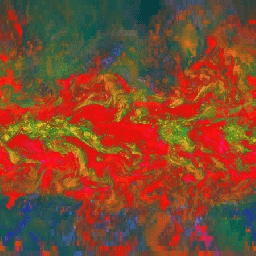
 var

 dataset

 =

 ee
 .
 ImageCollection
 (
 'NOAA/CDR/PATMOSX/V53'
 )

 .
 filter
 (
 ee
 .
 Filter
 .
 date
 (
 '2017-05-01'
 ,

 '2017-05-14'
 ));
 var

 cloudEmissivityAndHeight

 =

 dataset
 .
 select
 (

 [
 'cld_emiss_acha'
 ,

 'cld_height_acha'
 ,

 'cld_height_uncer_acha'
 ]);
 Map
 .
 setCenter
 (
 71.72
 ,

 52.48
 ,

 1
 );
 Map
 .
 addLayer
 (
 cloudEmissivityAndHeight
 ,

 {},

 'Cloud Emissivity and Height'
 );