
AI-generated Key Takeaways
-
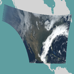
The dataset contains Cloud and Moisture Imagery products from GOES-19 with a 2km resolution, available from April 7, 2025.
-
Bands 1-6 are reflective and used to characterize clouds, vegetation, snow/ice, and aerosols, while bands 7-16 are emissive for characterizing the surface, clouds, water vapor, ozone, volcanic ash, and dust.
-
Data is provided by NOAA and updated every 10 minutes.
-
The dataset includes data quality flags for each band, indicating pixel usability and other conditions.
- Dataset Availability
- 2025-04-07T00:00:00Z–2025-11-17T11:11:17.500000Z
- Dataset Provider
- NOAA
- Cadence
- 10 Minutes
- Tags
Description
The Cloud and Moisture Imagery products are all at 2km resolution. Bands 1-6 are reflective. The dimensionless "reflectance factor" quantity is normalized by the solar zenith angle. These bands support the characterization of clouds, vegetation, snow/ice, and aerosols. Bands 7-16 are emissive. The brightness temperature at the Top-Of-Atmosphere (TOA) is measured in Kelvin. These bands support the characterization of the surface, clouds, water vapor, ozone, volcanic ash, and dust based on emissive properties.
Operational data production for GOES-19 began April 7, 2025. Any data prior to this date is provisional.
NOAA's Office of Satellite and Product Operations has a General Satellite Messages channel with status updates.
Bands
Pixel Size 2000 meters
Bands
| Name | Units | Min | Max | Pixel Size | Wavelength | Description |
|---|---|---|---|---|---|---|
CMI_C01
|
Reflectance factor | 0 | 1.3 | meters | 0.45-0.49µm | Visible - Blue Daytime aerosol over land, coastal water mapping. |
DQF_C01
|
0 | 4 | meters | None | Data quality flags |
|
CMI_C02
|
Reflectance factor | 0 | 1.3 | meters | 0.59-0.69µm | Visible - Red Daytime clouds, fog, insolation, winds |
DQF_C02
|
0 | 4 | meters | None | Data quality flags |
|
CMI_C03
|
Reflectance factor | 0 | 1.3 | meters | 0.846-0.885µm | Near-IR - Veggie Daytime vegetation, burn scar, aerosol over water, winds |
DQF_C03
|
0 | 4 | meters | None | Data quality flags |
|
CMI_C04
|
Reflectance factor | 0 | 1.3 | meters | 1.371-1.386µm | Near-IR - Cirrus Daytime cirrus cloud |
DQF_C04
|
0 | 4 | meters | None | Data quality flags |
|
CMI_C05
|
Reflectance factor | 0 | 1.3 | meters | 1.58-1.64µm | Near-IR - Snow/Ice Daytime cloud-top phase and particle size, snow |
DQF_C05
|
0 | 4 | meters | None | Data quality flags |
|
CMI_C06
|
Reflectance factor | 0 | 1.3 | meters | 2.225-2.275µm | Near IR - Cloud Particle Size Daytime land, cloud properties, particle size, vegetation, snow |
DQF_C06
|
0 | 4 | meters | None | Data quality flags |
|
CMI_C07
|
K | 197.31 | 411.86 | meters | 3.80-4.00µm | Infrared - Shortwave Window Brightness |
DQF_C07
|
0 | 4 | meters | None | Data quality flags |
|
CMI_C08
|
K | 138.05 | 311.06 | meters | 5.77-6.6µm | Infrared - Upper-level water vapor High-level atmospheric water vapor, winds, rainfall Brightness |
DQF_C08
|
0 | 4 | meters | None | Data quality flags |
|
CMI_C09
|
K | 137.7 | 311.08 | meters | 6.75-7.15µm | Infrared - Mid-level water vapor Mid-level atmospheric water vapor, winds, rainfall Brightness |
DQF_C09
|
0 | 4 | meters | None | Data quality flags |
|
CMI_C10
|
K | 126.91 | 331.2 | meters | 7.24-7.44µm | Infrared - Lower-level water vapor Lower-level water vapor, winds, and sulfur dioxide Brightness |
DQF_C10
|
0 | 4 | meters | None | Data quality flags |
|
CMI_C11
|
K | 127.69 | 341.3 | meters | 8.3-8.7µm | Infrared - Cloud-top phase Total water for stability, cloud phase, dust, sulfur dioxide, rainfall Brightness |
DQF_C11
|
0 | 4 | meters | None | Data quality flags |
|
CMI_C12
|
K | 117.49 | 311.06 | meters | 9.42-9.8µm | Infrared - Ozone Total ozone, turbulence, winds |
DQF_C12
|
0 | 4 | meters | None | Data quality flags |
|
CMI_C13
|
K | 89.62 | 341.27 | meters | 10.1-10.6µm | Infrared - "Clean" longwave window Surface and clouds Brightness |
DQF_C13
|
0 | 4 | meters | None | Data quality flags |
|
CMI_C14
|
K | 96.19 | 341.28 | meters | 10.8-11.6µm | Infrared - Longwave window Imagery, sea surface temperature, clouds, rainfall Brightness |
DQF_C14
|
0 | 4 | meters | None | Data quality flags |
|
CMI_C15
|
K | 97.38 | 341.28 | meters | 11.8-12.8µm | Infrared "Dirty" longwave Total water, volcanic ash, sea surface temperature Brightness |
DQF_C15
|
0 | 4 | meters | None | Data quality flags |
|
CMI_C16
|
K | 92.7 | 318.26 | meters | 13.0-13.6µm | Infrared - CO_2 longwave Air temperature, cloud heights Brightness |
DQF_C16
|
0 | 4 | meters | None | Data quality flags |
DQF_C01 Class Table
| Value | Color | Description |
|---|---|---|
|
0
|
#ffffff | Good pixels |
|
1
|
#ff00ff | Conditionally usable pixels |
|
2
|
#0000ff | Out of range pixels |
|
3
|
#00ffff | No value pixels |
|
4
|
#ffff00 | Focal plane temperature threshold exceeded |
DQF_C02 Class Table
| Value | Color | Description |
|---|---|---|
|
0
|
#ffffff | Good pixels |
|
1
|
#ff00ff | Conditionally usable pixels |
|
2
|
#0000ff | Out of range pixels |
|
3
|
#00ffff | No value pixels |
|
4
|
#ffff00 | Focal plane temperature threshold exceeded |
DQF_C03 Class Table
| Value | Color | Description |
|---|---|---|
|
0
|
#ffffff | Good pixels |
|
1
|
#ff00ff | Conditionally usable pixels |
|
2
|
#0000ff | Out of range pixels |
|
3
|
#00ffff | No value pixels |
|
4
|
#ffff00 | Focal plane temperature threshold exceeded |
DQF_C04 Class Table
| Value | Color | Description |
|---|---|---|
|
0
|
#ffffff | Good pixels |
|
1
|
#ff00ff | Conditionally usable pixels |
|
2
|
#0000ff | Out of range pixels |
|
3
|
#00ffff | No value pixels |
|
4
|
#ffff00 | Focal plane temperature threshold exceeded |
DQF_C05 Class Table
| Value | Color | Description |
|---|---|---|
|
0
|
#ffffff | Good pixels |
|
1
|
#ff00ff | Conditionally usable pixels |
|
2
|
#0000ff | Out of range pixels |
|
3
|
#00ffff | No value pixels |
|
4
|
#ffff00 | Focal plane temperature threshold exceeded |
DQF_C06 Class Table
| Value | Color | Description |
|---|---|---|
|
0
|
#ffffff | Good pixels |
|
1
|
#ff00ff | Conditionally usable pixels |
|
2
|
#0000ff | Out of range pixels |
|
3
|
#00ffff | No value pixels |
|
4
|
#ffff00 | Focal plane temperature threshold exceeded |
DQF_C07 Class Table
| Value | Color | Description |
|---|---|---|
|
0
|
#ffffff | Good pixels |
|
1
|
#ff00ff | Conditionally usable pixels |
|
2
|
#0000ff | Out of range pixels |
|
3
|
#00ffff | No value pixels |
|
4
|
#ffff00 | Focal plane temperature threshold exceeded |
DQF_C08 Class Table
| Value | Color | Description |
|---|---|---|
|
0
|
#ffffff | Good pixels |
|
1
|
#ff00ff | Conditionally usable pixels |
|
2
|
#0000ff | Out of range pixels |
|
3
|
#00ffff | No value pixels |
|
4
|
#ffff00 | Focal plane temperature threshold exceeded |
DQF_C09 Class Table
| Value | Color | Description |
|---|---|---|
|
0
|
#ffffff | Good pixels |
|
1
|
#ff00ff | Conditionally usable pixels |
|
2
|
#0000ff | Out of range pixels |
|
3
|
#00ffff | No value pixels |
|
4
|
#ffff00 | Focal plane temperature threshold exceeded |
DQF_C10 Class Table
| Value | Color | Description |
|---|---|---|
|
0
|
#ffffff | Good pixels |
|
1
|
#ff00ff | Conditionally usable pixels |
|
2
|
#0000ff | Out of range pixels |
|
3
|
#00ffff | No value pixels |
|
4
|
#ffff00 | Focal plane temperature threshold exceeded |
DQF_C11 Class Table
| Value | Color | Description |
|---|---|---|
|
0
|
#ffffff | Good pixels |
|
1
|
#ff00ff | Conditionally usable pixels |
|
2
|
#0000ff | Out of range pixels |
|
3
|
#00ffff | No value pixels |
|
4
|
#ffff00 | Focal plane temperature threshold exceeded |
DQF_C12 Class Table
| Value | Color | Description |
|---|---|---|
|
0
|
#ffffff | Good pixels |
|
1
|
#ff00ff | Conditionally usable pixels |
|
2
|
#0000ff | Out of range pixels |
|
3
|
#00ffff | No value pixels |
|
4
|
#ffff00 | Focal plane temperature threshold exceeded |
DQF_C13 Class Table
| Value | Color | Description |
|---|---|---|
|
0
|
#ffffff | Good pixels |
|
1
|
#ff00ff | Conditionally usable pixels |
|
2
|
#0000ff | Out of range pixels |
|
3
|
#00ffff | No value pixels |
|
4
|
#ffff00 | Focal plane temperature threshold exceeded |
DQF_C14 Class Table
| Value | Color | Description |
|---|---|---|
|
0
|
#ffffff | Good pixels |
|
1
|
#ff00ff | Conditionally usable pixels |
|
2
|
#0000ff | Out of range pixels |
|
3
|
#00ffff | No value pixels |
|
4
|
#ffff00 | Focal plane temperature threshold exceeded |
DQF_C15 Class Table
| Value | Color | Description |
|---|---|---|
|
0
|
#ffffff | Good pixels |
|
1
|
#ff00ff | Conditionally usable pixels |
|
2
|
#0000ff | Out of range pixels |
|
3
|
#00ffff | No value pixels |
|
4
|
#ffff00 | Focal plane temperature threshold exceeded |
DQF_C16 Class Table
| Value | Color | Description |
|---|---|---|
|
0
|
#ffffff | Good pixels |
|
1
|
#ff00ff | Conditionally usable pixels |
|
2
|
#0000ff | Out of range pixels |
|
3
|
#00ffff | No value pixels |
|
4
|
#ffff00 | Focal plane temperature threshold exceeded |
Image Properties
Image Properties
| Name | Type | Description |
|---|---|---|
|
CMI_C01_offset
|
DOUBLE | Offset to add to scaled CMI_C01 values |
|
CMI_C01_scale
|
DOUBLE | Scale to multiply with raw CMI_C01 values |
|
CMI_C02_offset
|
DOUBLE | Offset to add to scaled CMI_C02 values |
|
CMI_C02_scale
|
DOUBLE | Scale to multiply with raw CMI_C02 values |
|
CMI_C03_offset
|
DOUBLE | Offset to add to scaled CMI_C03 values |
|
CMI_C03_scale
|
DOUBLE | Scale to multiply with raw CMI_C03 values |
|
CMI_C04_offset
|
DOUBLE | Offset to add to scaled CMI_C04 values |
|
CMI_C04_scale
|
DOUBLE | Scale to multiply with raw CMI_C04 values |
|
CMI_C05_offset
|
DOUBLE | Offset to add to scaled CMI_C05 values |
|
CMI_C05_scale
|
DOUBLE | Scale to multiply with raw CMI_C05 values |
|
CMI_C06_offset
|
DOUBLE | Offset to add to scaled CMI_C06 values |
|
CMI_C06_scale
|
DOUBLE | Scale to multiply with raw CMI_C06 values |
|
CMI_C07_offset
|
DOUBLE | Offset to add to scaled CMI_C07 values |
|
CMI_C07_scale
|
DOUBLE | Scale to multiply with raw CMI_C07 values |
|
CMI_C08_offset
|
DOUBLE | Offset to add to scaled CMI_C08 values |
|
CMI_C08_scale
|
DOUBLE | Scale to multiply with raw CMI_C08 values |
|
CMI_C09_offset
|
DOUBLE | Offset to add to scaled CMI_C09 values |
|
CMI_C09_scale
|
DOUBLE | Scale to multiply with raw CMI_C09 values |
|
CMI_C10_offset
|
DOUBLE | Offset to add to scaled CMI_C10 values |
|
CMI_C10_scale
|
DOUBLE | Scale to multiply with raw CMI_C10 values |
|
CMI_C11_offset
|
DOUBLE | Offset to add to scaled CMI_C11 values |
|
CMI_C11_scale
|
DOUBLE | Scale to multiply with raw CMI_C11 values |
|
CMI_C12_offset
|
DOUBLE | Offset to add to scaled CMI_C12 values |
|
CMI_C12_scale
|
DOUBLE | Scale to multiply with raw CMI_C12 values |
|
CMI_C13_offset
|
DOUBLE | Offset to add to scaled CMI_C13 values |
|
CMI_C13_scale
|
DOUBLE | Scale to multiply with raw CMI_C13 values |
|
CMI_C14_offset
|
DOUBLE | Offset to add to scaled CMI_C14 values |
|
CMI_C14_scale
|
DOUBLE | Scale to multiply with raw CMI_C14 values |
|
CMI_C15_offset
|
DOUBLE | Offset to add to scaled CMI_C15 values |
|
CMI_C15_scale
|
DOUBLE | Scale to multiply with raw CMI_C15 values |
|
CMI_C16_offset
|
DOUBLE | Offset to add to scaled CMI_C16 values |
|
CMI_C16_scale
|
DOUBLE | Scale to multiply with raw CMI_C16 values |
Terms of Use
Terms of Use
NOAA data, information, and products, regardless of the method of delivery, are not subject to copyright and carry no restrictions on their subsequent use by the public. Once obtained, they may be put to any lawful use.
Citations
-
Bah, Gunshor, Schmit, Generation of GOES-16 True Color Imagery without a Green Band, 2018. doi:10.1029/2018EA000379
-
Product User Guide (PUG) Volume 5, L2+ Products .
-
Schmit, T., Griffith, P., et al, (2016), A closer look at the ABI on the GOES-R series, Bull. Amer. Meteor. Soc., 98(4), 681-698. doi:10.1175/BAMS-D-15-00230.1
DOIs
Explore with Earth Engine
Code Editor (JavaScript)
 // Band aliases.
 var

 BLUE

 =

 'CMI_C01'
 ;
 var

 RED

 =

 'CMI_C02'
 ;
 var

 VEGGIE

 =

 'CMI_C03'
 ;
 var

 GREEN

 =

 'GREEN'
 ;
 // 16 pairs of CMI and DQF followed by Bah 2018 synthetic green.
 // Band numbers in the EE asset, 0-based.
 var

 NUM_BANDS

 =

 33
 ;
 // Skipping the interleaved DQF bands.
 var

 BLUE_BAND_INDEX

 =

 (
 1

 -

 1
 )

 *

 2
 ;
 var

 RED_BAND_INDEX

 =

 (
 2

 -

 1
 )

 *

 2
 ;
 var

 VEGGIE_BAND_INDEX

 =

 (
 3

 -

 1
 )

 *

 2
 ;
 var

 GREEN_BAND_INDEX

 =

 NUM_BANDS

 -

 1
 ;
 // Visualization range for GOES RGB.
 var

 GOES_MIN

 =

 0.0
 ;
 var

 GOES_MAX

 =

 0.7
 ;

 // Alternatively 1.0 or 1.3.
 var

 GAMMA

 =

 1.3
 ;
 var

 goesRgbViz

 =

 {

 bands
 :

 [
 RED
 ,

 GREEN
 ,

 BLUE
 ],

 min
 :

 GOES_MIN
 ,

 max
 :

 GOES_MAX
 ,

 gamma
 :

 GAMMA
 };
 var

 applyScaleAndOffset

 =

 function
 (
 image
 )

 {

 image

 =

 ee
 .
 Image
 (
 image
 );

 var

 bands

 =

 new

 Array
 (
 NUM_BANDS
 );

 for

 (
 var

 i

 =

 1
 ;

 i
 <
 17
 ;

 i
 ++
 )

 {

 var

 bandName

 =

 'CMI_C'

 +

 (
 100

 +

 i

 +

 ''
 ).
 slice
 (
 -
 2
 );

 var

 offset

 =

 ee
 .
 Number
 (
 image
 .
 get
 (
 bandName

 +

 '_offset'
 ));

 var

 scale

 =

 ee
 .
 Number
 (
 image
 .
 get
 (
 bandName

 +

 '_scale'
 ));

 bands
 [(
 i
 -
 1
 )

 *

 2
 ]

 =

 image
 .
 select
 (
 bandName
 ).
 multiply
 (
 scale
 ).
 add
 (
 offset
 );

 var

 dqfName

 =

 'DQF_C'

 +

 (
 100

 +

 i

 +

 ''
 ).
 slice
 (
 -
 2
 );

 bands
 [(
 i
 -
 1
 )

 *

 2

 +

 1
 ]

 =

 image
 .
 select
 (
 dqfName
 );

 }

 // Bah, Gunshor, Schmit, Generation of GOES-16 True Color Imagery without a

 // Green Band, 2018. https://doi.org/10.1029/2018EA000379

 // Green = 0.45 * Red + 0.10 * NIR + 0.45 * Blue

 var

 green1

 =

 bands
 [
 RED_BAND_INDEX
 ].
 multiply
 (
 0.45
 );

 var

 green2

 =

 bands
 [
 VEGGIE_BAND_INDEX
 ].
 multiply
 (
 0.10
 );

 var

 green3

 =

 bands
 [
 BLUE_BAND_INDEX
 ].
 multiply
 (
 0.45
 );

 var

 green

 =

 green1
 .
 add
 (
 green2
 ).
 add
 (
 green3
 );

 bands
 [
 GREEN_BAND_INDEX
 ]

 =

 green
 .
 rename
 (
 GREEN
 );

 return

 ee
 .
 Image
 (
 ee
 .
 Image
 (
 bands
 ).
 copyProperties
 (
 image
 ,

 image
 .
 propertyNames
 ()));
 };
 var

 collection

 =

 'NOAA/GOES/19/MCMIPC/'
 ;
 var

 imageName

 =

 '2025097161117300000'
 ;
 var

 assetId

 =

 collection

 +

 imageName
 ;
 var

 image

 =

 applyScaleAndOffset
 (
 assetId
 );
 Map
 .
 setCenter
 (
 -
 75
 ,

 37
 ,

 5
 );
 Map
 .
 addLayer
 (
 image
 ,

 goesRgbViz
 );