
Page Summary
-
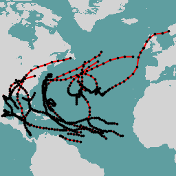
This dataset provides the Hurricane best track database (HURDAT2) for the Atlantic basin from 1851 to 2018.
-
The data includes details such as hurricane name, observation time, record ID, status, maximum wind speed, minimum pressure, and wind radii in different quadrants.
-
NOAA data, including this dataset, is not subject to copyright and can be used freely for any lawful purpose.
-
The dataset can be explored and analyzed using Google Earth Engine.
- Dataset Availability
- 1851-06-25T00:00:00Z–2018-11-04T12:00:00Z
- Dataset Producer
- NOAA NHC
- Tags
Description
Hurricane best track database (HURDAT2).
Atlantic basin 1851-2018.
Table Schema
Table Schema
ATCF cyclone number for that year
Hurricane name. e.g. "ALEX"
Observation time in UTC. Format is YYYY-MM-DDTHH:MM:SS.
Single letter desinating a specific event in a hurricane track. An empty string if no code.
- C - Closest approach to a coast not followed by a landfall
- G - Genesis
- I - An intensity peak in terms of both pressure and wind
- L - Landfall (center of system crossing a coastline)
- P - Minimum in central pressure
- R - Provides additional detail on the intensity of the cyclone when rapid changes are underway
- S - Change of status of the system
- T - Provides additional detail on the track (position) of the cyclone
- W - Maximum sustained wind speed
Status of system:
- DB - Disturbance (of any intensity)
- ET - Unknown. The only occurrence is in HARVEY.
- EX - Extratropical cyclone (of any intensity)
- HU - Tropical cyclone of hurricane intensity (> 64 knots)
- LO - A low that is neither a tropical cyclone, a subtropical cyclone, nor an extratropical cyclone (of any intensity)
- SD - Subtropical cyclone of subtropical depression intensity (< 34 knots)
- SS - Subtropical cyclone of subtropical storm intensity (> 34 knots)
- TD - Tropical cyclone of tropical depression intensity (< 34 knots)
- TS - Tropical cyclone of tropical storm intensity (34-63 knots)
- WV - Tropical Wave (of any intensity)
Maximum wind speed
Minimum pressure
Number of points for a particular hurricane
34 kt wind radii maximum extent in northeastern quadrant
34 kt wind radii maximum extent in southeastern quadrant
34 kt wind radii maximum extent in southwestern quadrant
34 kt wind radii maximum extent in northwestern quadrant
50 kt wind radii maximum extent in northeastern quadrant
50 kt wind radii maximum extent in southeastern quadrant
50 kt wind radii maximum extent in southwestern quadrant
50 kt wind radii maximum extent in northwestern quadrant
64 kt wind radii maximum extent in northeastern quadrant
64 kt wind radii maximum extent in southeastern quadrant
64 kt wind radii maximum extent in southwestern quadrant
64 kt wind radii maximum extent in northwestern quadrant
Ocean basin. Always "AL" for Atlantic.
Code for a particular hurricane. "AL" followed by a 2 digit cyclone number followed by a 4-digit year. e.g. "AL162018"
Year in which the hurricane occurred
Terms of Use
Terms of Use
NOAA data, information, and products, regardless of the method of delivery, are not subject to copyright and carry no restrictions on their subsequent use by the public. Once obtained, they may be put to any lawful use.
Explore with Earth Engine
Code Editor (JavaScript)
 // Show hurricane tracks and points for 2017.
 var

 hurricanes

 =

 ee
 .
 FeatureCollection
 (
 'NOAA/NHC/HURDAT2/atlantic'
 );
 var

 year

 =

 '2017'
 ;
 var

 points

 =

 hurricanes
 .
 filter
 (
 ee
 .
 Filter
 .
 date
 (
 ee
 .
 Date
 (
 year
 ).
 getRange
 (
 'year'
 )));
 // Find all of the hurricane ids.
 var

 GetId

 =

 function
 (
 point
 )

 {

 return

 ee
 .
 Feature
 (
 point
 ).
 get
 (
 'id'
 );
 };
 var

 storm_ids

 =

 points
 .
 toList
 (
 1000
 ).
 map
 (
 GetId
 ).
 distinct
 ();
 // Create a line for each hurricane.
 var

 lines

 =

 ee
 .
 FeatureCollection
 (
 storm_ids
 .
 map
 (
 function
 (
 storm_id
 ){

 var

 pts

 =

 points
 .
 filter
 (
 ee
 .
 Filter
 .
 eq
 (
 'id'
 ,

 ee
 .
 String
 (
 storm_id
 )));

 pts

 =

 pts
 .
 sort
 (
 'system:time_start'
 );

 var

 line

 =

 ee
 .
 Geometry
 .
 LineString
 (
 pts
 .
 geometry
 ().
 coordinates
 ());

 var

 feature

 =

 ee
 .
 Feature
 (
 line
 );

 return

 feature
 .
 set
 (
 'id'
 ,

 storm_id
 );
 }));
 Map
 .
 addLayer
 (
 lines
 ,

 {
 color
 :

 'red'
 },

 'tracks'
 );
 Map
 .
 addLayer
 (
 points
 ,

 {
 color
 :

 'black'
 },

 'points'
 );
 Map
 .
 setCenter
 (
 -
 53
 ,

 36
 ,

 3
 );
Visualize as a FeatureView
A FeatureView
is a view-only, accelerated representation of a FeatureCollection
. For more details, visit the FeatureView
documentation.
Code Editor (JavaScript)
 var

 fvLayer

 =

 ui
 .
 Map
 .
 FeatureViewLayer
 (
 'NOAA/NHC/HURDAT2/atlantic_FeatureView'
 );
 var

 visParams

 =

 {

 isVisible
 :

 false
 ,

 pointSize
 :

 20
 ,

 rules
 :

 [

 {

 filter
 :

 ee
 .
 Filter
 .
 eq
 (
 'year'
 ,

 2018
 ),

 isVisible
 :

 true
 ,

 pointFillColor
 :

 {

 property
 :

 'max_wind_kts'
 ,

 mode
 :

 'linear'
 ,

 palette
 :

 [
 'f1eef6'
 ,

 'd7b5d8'
 ,

 'df65b0'
 ,

 'ce1256'
 ],

 min
 :

 15
 ,

 max
 :

 115

 }

 }

 ]
 };
 fvLayer
 .
 setVisParams
 (
 visParams
 );
 fvLayer
 .
 setName
 (
 '2018 hurricane max wind speed'
 );
 Map
 .
 setLocked
 (
 false
 ,

 4
 );
 Map
 .
 setCenter
 (
 -
 62.25
 ,

 32.19
 ,

 4
 );
 Map
 .
 add
 (
 fvLayer
 );