
AI-generated Key Takeaways
-
The Landsat Image Mosaic of Antarctica (LIMA) is a seamless and virtually cloudless mosaic created from processed Landsat 7 ETM+ scenes.
-
The dataset contains metadata for the LIMA image collection, including acquisition date, WRS path and row, and scene ID.
-
These images are in the public domain and can be used freely, though credit to the LIMA Project is appreciated.
-
The dataset is available from 1999-06-30 to 2002-09-04.
- Dataset Availability
- 1999-06-30T00:00:00Z–2002-09-04T00:00:00Z
- Dataset Provider
- USGS
- Tags
Description
The Landsat Image Mosaic of Antarctica (LIMA) is a seamless and virtually cloudless mosaic created from processed Landsat 7 ETM+ scenes.
Processed Landsat Scenes (16 bit) are Level 1Gt NLAPS scenes converted to 16 bit, processed with sun-angle correction, and converted to reflectance values ( Bindschadler 2008 ).
Each Landsat scene is processed with elevation data and sun-angle correction to ensure surface features were accurately represented. The sun's angle in Antarctica gives the appearance of a setting sun. Because of the low sun angle, as Landsat passes over Antarctica, the outer edges of the continent appear brighter than areas closer to the South Pole, so scenes have bright and dark areas. Inconsistent sun angles and shadows where corrected for these scenes. Without this process, mosaicking would produce a patchwork of scenes since each scene would have a brighter and a darker side.
This is a table which contains metadata for the Image Collection USGS/LIMA/SR
Table Schema
Table Schema
| Name | Type | Description |
|---|---|---|
|
ACQ_DATE
|
STRING | Acquisition date in YYYY-MM-DD format |
|
PATH
|
INT | WRS path |
|
POLY_ID
|
INT | Unique ID assigned to a polygon |
|
ROW
|
INT | WRS row |
|
SCENE_ID
|
STRING | Scene ID |
|
SENSOR
|
STRING | Sensor |
|
SPACE
|
STRING | Name of the satellite used to gather data |
Terms of Use
Terms of Use
These images are in the public domain and can be used freely and without acknowledgement. However, credit to the Landsat Image Mosaic of Antarctica (LIMA) Project is greatly appreciated.
Citations
-
Bindschadler, R., Vornberger, P., Fleming, A., Fox, A., Mullins, J., Binnie, D., Paulson, S., Granneman, B., and Gorodetzky, D., 2008, The Landsat Image Mosaic of Antarctica, Remote Sensing of Environment, 112, pp. 4214-4226. PDF
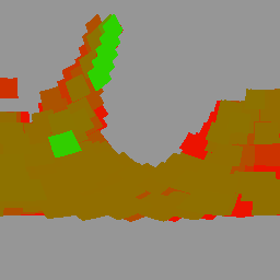
Explore with Earth Engine
Code Editor (JavaScript)
 var

 dataset

 =

 ee
 .
 FeatureCollection
 (
 'USGS/LIMA/SR_METADATA'
 );
 // Calculate the age of each feature by subtracting
 // the acquisition date from "today".
 var

 feature_ages

 =

 dataset
 .
 map
 (

 function
 (
 feature
 )

 {

 var

 today

 =

 ee
 .
 Date
 .
 fromYMD
 (
 2024
 ,

 1
 ,

 12
 );

 var

 acq_date

 =

 ee
 .
 Date
 .
 parse
 (

 'yyyy-MM-dd'
 ,

 feature
 .
 get
 (
 'ACQ_DATE'
 ));

 var

 diff

 =

 today
 .
 difference
 (
 acq_date
 ,

 'day'
 );

 return

 feature
 .
 set
 ({
 'ACQ_AGE'
 :

 diff
 });

 }
 );
 // Reduce by calculating the smallest ACQ_AGE,
 // which gives the most recent acquisition date for
 // that area.
 var

 reduced_ages

 =

 feature_ages
 .
 reduceToImage
 ({

 properties
 :

 [
 'ACQ_AGE'
 ],

 reducer
 :

 ee
 .
 Reducer
 .
 min
 ()
 });
 var

 reduced_ages_vis

 =

 {

 min
 :

 6000
 ,

 max
 :

 9000
 ,

 palette
 :

 [
 '00ff00'
 ,

 'ff0000'
 ],
 };
 var

 lon

 =

 -
 43.6
 ;
 var

 lat

 =

 -
 74.2
 ;
 var

 gray

 =

 150
 ;
 var

 background

 =

 ee
 .
 Image
 .
 rgb
 (
 gray
 ,

 gray
 ,

 gray
 ).
 visualize
 ({
 min
 :

 0
 ,

 max
 :

 255
 });
 Map
 .
 setCenter
 (
 lon
 ,

 lat
 ,

 2
 );
 Map
 .
 addLayer
 (

 reduced_ages
 ,

 reduced_ages_vis
 ,

 'Acquisition Age'
 );