
AI-generated Key Takeaways
-
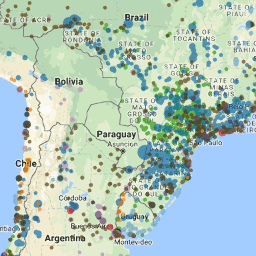
The Global Power Plant Database is an open source database with geolocated information on power plants worldwide, including capacity, generation, ownership, and fuel type.
-
As of June 2018, the database contains information on approximately 28,500 power plants across 164 countries.
-
The dataset can be explored and visualized using Google Earth Engine's Code Editor and FeatureView options.
-
The dataset is available under the CC-BY-4.0 license and users are requested to register their use with the provider, WRI.
- Dataset Availability
- 2018-06-11T00:00:00Z–2018-06-11T00:00:00Z
- Dataset Provider
- World Resources Institute
- Tags
Description
The Global Power Plant Database is a comprehensive, open source database of power plants around the world. It centralizes power plant data to make it easier to navigate, compare and draw insights. Each power plant is geolocated and entries contain information on plant capacity, generation, ownership, and fuel type. As of June 2018, the database includes around 28,500 power plants from 164 countries. It will be continuously updated as data becomes available.
The methodology for the dataset creation is given in the World Resources Institute publication "A Global Database of Power Plants" .
Associated code for the creation of the dataset can be found on GitHub . The bleeding-edge version of the database (which may contain substantial differences from the release in Earth Engine) is available on GitHub as well.
If you use this dataset, the provider (WRI) has requested that you register your use and (optionally) sign up to receive update notifications.
Table Schema
Table Schema
| Name | Type | Description |
|---|---|---|
|
country
|
STRING | 3-character country code corresponding to the ISO 3166-1 alpha-3 specs |
|
country_lg
|
STRING | Longer form of the country designation |
|
name
|
STRING | Name or title of the power plant, generally in Romanized form |
|
gppd_idnr
|
STRING | 10- or 12-character identifier for the power plant |
|
capacitymw
|
DOUBLE | Electrical generating capacity in megawatts |
|
latitude
|
DOUBLE | Geolocation in decimal degrees |
|
longitude
|
DOUBLE | Geolocation in decimal degrees |
|
fuel1
|
STRING | Energy source used in electricity generation or export |
|
fuel2
|
STRING | Energy source used in electricity generation or export |
|
fuel3
|
STRING | Energy source used in electricity generation or export |
|
fuel4
|
STRING | Energy source used in electricity generation or export |
|
comm_year
|
STRING | Year of plant operation, weighted by unit-capacity when data is available |
|
owner
|
STRING | Majority shareholder of the power plant, generally in Romanized form |
|
source
|
STRING | Entity reporting the data; could be an organization, report, or document, generally in Romanized form |
|
url
|
STRING | Web document corresponding to the "source" field |
|
src_latlon
|
STRING | Attribution for geolocation information |
|
cap_year
|
DOUBLE | Year the capacity information was reported |
|
gwh_2013
|
DOUBLE | Electricity generation in gigawatt-hours reported for the year 2013 |
|
gwh_2014
|
DOUBLE | Electricity generation in gigawatt-hours reported for the year 2014 |
|
gwh_2015
|
DOUBLE | Electricity generation in gigawatt-hours reported for the year 2015 |
|
gwh_2016
|
DOUBLE | Electricity generation in gigawatt-hours reported for the year 2016 |
|
gwh_estimt
|
DOUBLE | Estimated annual electricity generation in gigawatt-hours for the year 2015 |
Terms of Use
Terms of Use
Citations
-
Global Energy Observatory, Google, KTH Royal Institute of Technology in Stockholm, University of Groningen, World Resources Institute. 2018. Global Power Plant Database. Published on Resource Watch and Google Earth Engine; https://resourcewatch.org/ https://earthengine.google.com/
Explore with Earth Engine
Code Editor (JavaScript)
 // Visualization for WRI/GPPD/power_plants
 var

 table

 =

 ee
 .
 FeatureCollection
 (
 'WRI/GPPD/power_plants'
 );
 // Get a color from a fuel
 var

 fuelColor

 =

 ee
 .
 Dictionary
 ({

 'Coal'
 :

 '000000'
 ,

 'Oil'
 :

 '593704'
 ,

 'Gas'
 :

 'bc80bd'
 ,

 'Hydro'
 :

 '0565A6'
 ,

 'Nuclear'
 :

 'e31a1c'
 ,

 'Solar'
 :

 'ff7f00'
 ,

 'Waste'
 :

 '6a3d9a'
 ,

 'Wind'
 :

 '5ca2d1'
 ,

 'Geothermal'
 :

 'fdbf6f'
 ,

 'Biomass'
 :

 '229a00'
 });
 // List of fuels to add to the map
 var

 fuels

 =

 [

 'Coal'
 ,

 'Oil'
 ,

 'Gas'
 ,

 'Hydro'
 ,

 'Nuclear'
 ,

 'Solar'
 ,

 'Waste'
 ,

 'Wind'
 ,

 'Geothermal'
 ,

 'Biomass'
 ];
 /**
 * Computes size from capacity and color from fuel type.
 *
 * @param {!ee.Geometry.Point} pt A point
 * @return {!ee.Geometry.Point} Input point with added style dictionary.
 */
 function

 addStyle
 (
 pt
 )

 {

 var

 size

 =

 ee
 .
 Number
 (
 pt
 .
 get
 (
 'capacitymw'
 )).
 sqrt
 ().
 divide
 (
 10
 ).
 add
 (
 2
 );

 var

 color

 =

 fuelColor
 .
 get
 (
 pt
 .
 get
 (
 'fuel1'
 ));

 return

 pt
 .
 set
 (

 'styleProperty'
 ,

 ee
 .
 Dictionary
 ({
 'pointSize'
 :

 size
 ,

 'color'
 :

 color
 }));
 }
 // Make a FeatureCollection out of the power plant data table.
 var

 pp

 =

 ee
 .
 FeatureCollection
 (
 table
 ).
 map
 (
 addStyle
 );
 print
 (
 pp
 .
 first
 ());
 /**
 * Adds power plants of a certain fuel type to the map.
 *
 * @param {string} fuel A fuel type
 */
 function

 addLayer
 (
 fuel
 )

 {

 print
 (
 fuel
 );

 Map
 .
 addLayer
 (

 pp
 .
 filter
 (
 ee
 .
 Filter
 .
 eq
 (
 'fuel1'
 ,

 fuel
 ))

 .
 style
 ({
 styleProperty
 :

 'styleProperty'
 ,

 neighborhood
 :

 50
 }),

 {},

 fuel
 ,

 true
 ,

 0.65
 );
 }
 // Apply `addLayer` to each record in `fuels`.
 fuelColor
 .
 keys
 ().
 evaluate
 (
 function
 (
 fuelsList
 )

 {

 fuelsList
 .
 map
 (
 addLayer
 );
 });
Visualize as a FeatureView
A FeatureView
is a view-only, accelerated representation of a FeatureCollection
. For more details, visit the FeatureView
documentation.
Code Editor (JavaScript)
 var

 fvLayer

 =

 ui
 .
 Map
 .
 FeatureViewLayer
 (
 'WRI/GPPD/power_plants_FeatureView'
 );
 var

 visParams

 =

 {

 opacity
 :

 0.65
 ,

 color
 :

 {

 property
 :

 'fuel1'
 ,

 categories
 :

 [

 [
 'Coal'
 ,

 '000000'
 ],

 [
 'Oil'
 ,

 '593704'
 ],

 [
 'Gas'
 ,

 'bc80bd'
 ],

 [
 'Hydro'
 ,

 '0565a6'
 ],

 [
 'Nuclear'
 ,

 'e31a1c'
 ],

 [
 'Solar'
 ,

 'ff7f00'
 ],

 [
 'Waste'
 ,

 '6a3d9a'
 ],

 [
 'Wind'
 ,

 '5ca2d1'
 ],

 [
 'Geothermal'
 ,

 'fdbf6f'
 ],

 [
 'Biomass'
 ,

 '229a00'
 ]

 ],

 defaultValue
 :

 'ffffff'

 },

 rules
 :

 [

 {

 filter
 :

 ee
 .
 Filter
 .
 expression
 (
 'capacitymw < 500'
 ),

 pointSize
 :

 5
 ,

 },

 {

 filter
 :

 ee
 .
 Filter
 .
 expression
 (
 'capacitymw >= 500 AND capacitymw < 1000'
 ),

 pointSize
 :

 10
 ,

 },

 {

 filter
 :

 ee
 .
 Filter
 .
 expression
 (
 'capacitymw >= 1000'
 ),

 pointSize
 :

 15
 ,

 }

 ]
 };
 fvLayer
 .
 setVisParams
 (
 visParams
 );
 fvLayer
 .
 setName
 (
 'Power plant (fuel type and capacity)'
 );
 Map
 .
 setCenter
 (
 16
 ,

 49
 ,

 4
 );
 Map
 .
 add
 (
 fvLayer
 );