
AI-generated Key Takeaways
-
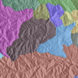
The Watershed Boundary Dataset (WBD) from USGS provides a comprehensive collection of hydrologic unit data at various levels, defining the extent of surface water drainage.
-
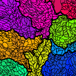
WWF's HydroATLAS Basins dataset, a component of HydroSHEDS, offers standardized hydro-environmental attribute information for global watersheds at high spatial resolution.
-
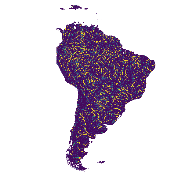
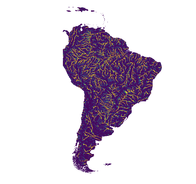
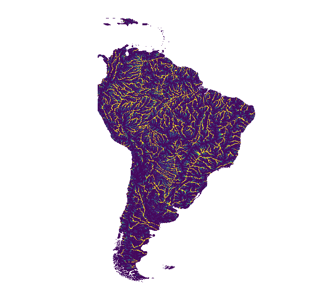
The HydroSHEDS mapping product from WWF provides consistent hydrographic information at regional and global scales, including river networks, watershed boundaries, and flow accumulation.
-
Both USGS and WWF datasets provide valuable information for hydrology, hydrography, and surface and ground water applications.
-
HUC02: USGS Watershed Boundary Dataset of Regions
The Watershed Boundary Dataset (WBD) is a comprehensive aggregated collection of hydrologic unit (HU) data consistent with the national criteria for delineation and resolution. It defines the areal extent of surface water drainage to a point except in coastal or lake front areas where there … hydrology surface-ground-water table usgs water watershed -
HUC04: USGS Watershed Boundary Dataset of Subregions

The Watershed Boundary Dataset (WBD) is a comprehensive aggregated collection of hydrologic unit (HU) data consistent with the national criteria for delineation and resolution. It defines the areal extent of surface water drainage to a point except in coastal or lake front areas where there … hydrology surface-ground-water table usgs water watershed -
HUC06: USGS Watershed Boundary Dataset of Basins

The Watershed Boundary Dataset (WBD) is a comprehensive aggregated collection of hydrologic unit (HU) data consistent with the national criteria for delineation and resolution. It defines the areal extent of surface water drainage to a point except in coastal or lake front areas where there … hydrology surface-ground-water table usgs water watershed -
HUC08: USGS Watershed Boundary Dataset of Subbasins

The Watershed Boundary Dataset (WBD) is a comprehensive aggregated collection of hydrologic unit (HU) data consistent with the national criteria for delineation and resolution. It defines the areal extent of surface water drainage to a point except in coastal or lake front areas where there … hydrology surface-ground-water table usgs water watershed -
HUC10: USGS Watershed Boundary Dataset of Watersheds

The Watershed Boundary Dataset (WBD) is a comprehensive aggregated collection of hydrologic unit (HU) data consistent with the national criteria for delineation and resolution. It defines the areal extent of surface water drainage to a point except in coastal or lake front areas where there … hydrology surface-ground-water table usgs water watershed -
HUC12: USGS Watershed Boundary Dataset of Subwatersheds

The Watershed Boundary Dataset (WBD) is a comprehensive aggregated collection of hydrologic unit (HU) data consistent with the national criteria for delineation and resolution. It defines the areal extent of surface water drainage to a point except in coastal or lake front areas where there … hydrology surface-ground-water table usgs water watershed -
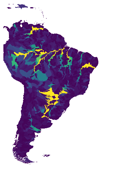
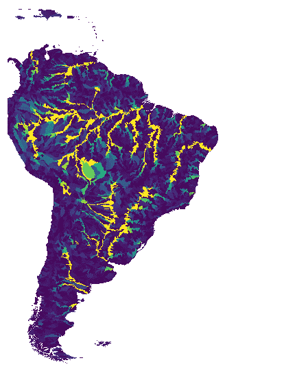
WWF HydroATLAS Basins Level 03
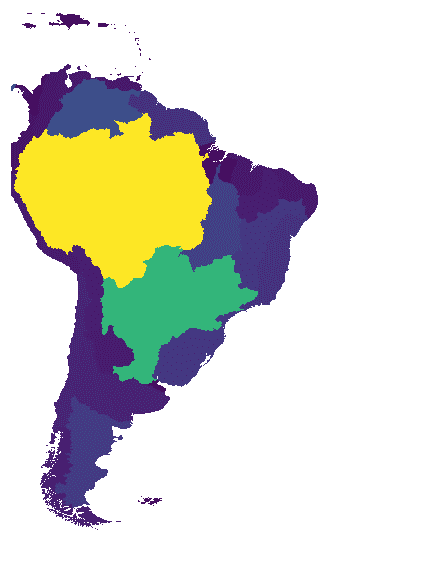
BasinATLAS is a component of the HydroATLAS database, which is a component of HydroSHEDS. BasinATLAS provides a standardized compendium of hydro-environmental attribute information for all watersheds of the world at high spatial resolution. This dataset includes data for 56 variables, partitioned into 281 attributes and … geophysical hydroatlas hydrography hydrology hydrosheds srtm -
WWF HydroATLAS Basins Level 04
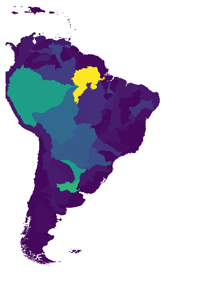
BasinATLAS is a component of the HydroATLAS database, which is a component of HydroSHEDS. BasinATLAS provides a standardized compendium of hydro-environmental attribute information for all watersheds of the world at high spatial resolution. This dataset includes data for 56 variables, partitioned into 281 attributes and … geophysical hydroatlas hydrography hydrology hydrosheds srtm -
WWF HydroATLAS Basins Level 05
BasinATLAS is a component of the HydroATLAS database, which is a component of HydroSHEDS. BasinATLAS provides a standardized compendium of hydro-environmental attribute information for all watersheds of the world at high spatial resolution. This dataset includes data for 56 variables, partitioned into 281 attributes and … geophysical hydroatlas hydrography hydrology hydrosheds srtm -
WWF HydroATLAS Basins Level 06
BasinATLAS is a component of the HydroATLAS database, which is a component of HydroSHEDS. BasinATLAS provides a standardized compendium of hydro-environmental attribute information for all watersheds of the world at high spatial resolution. This dataset includes data for 56 variables, partitioned into 281 attributes and … geophysical hydroatlas hydrography hydrology hydrosheds srtm -
WWF HydroATLAS Basins Level 07
BasinATLAS is a component of the HydroATLAS database, which is a component of HydroSHEDS. BasinATLAS provides a standardized compendium of hydro-environmental attribute information for all watersheds of the world at high spatial resolution. This dataset includes data for 56 variables, partitioned into 281 attributes and … geophysical hydroatlas hydrography hydrology hydrosheds srtm -
WWF HydroATLAS Basins Level 08
BasinATLAS is a component of the HydroATLAS database, which is a component of HydroSHEDS. BasinATLAS provides a standardized compendium of hydro-environmental attribute information for all watersheds of the world at high spatial resolution. This dataset includes data for 56 variables, partitioned into 281 attributes and … geophysical hydroatlas hydrography hydrology hydrosheds srtm -
WWF HydroATLAS Basins Level 09
BasinATLAS is a component of the HydroATLAS database, which is a component of HydroSHEDS. BasinATLAS provides a standardized compendium of hydro-environmental attribute information for all watersheds of the world at high spatial resolution. This dataset includes data for 56 variables, partitioned into 281 attributes and … geophysical hydroatlas hydrography hydrology hydrosheds srtm -
WWF HydroATLAS Basins Level 10
BasinATLAS is a component of the HydroATLAS database, which is a component of HydroSHEDS. BasinATLAS provides a standardized compendium of hydro-environmental attribute information for all watersheds of the world at high spatial resolution. This dataset includes data for 56 variables, partitioned into 281 attributes and … geophysical hydroatlas hydrography hydrology hydrosheds srtm -
WWF HydroATLAS Basins Level 11
BasinATLAS is a component of the HydroATLAS database, which is a component of HydroSHEDS. BasinATLAS provides a standardized compendium of hydro-environmental attribute information for all watersheds of the world at high spatial resolution. This dataset includes data for 56 variables, partitioned into 281 attributes and … geophysical hydroatlas hydrography hydrology hydrosheds srtm -
WWF HydroATLAS Basins Level 12
BasinATLAS is a component of the HydroATLAS database, which is a component of HydroSHEDS. BasinATLAS provides a standardized compendium of hydro-environmental attribute information for all watersheds of the world at high spatial resolution. This dataset includes data for 56 variables, partitioned into 281 attributes and … geophysical hydroatlas hydrography hydrology hydrosheds srtm -
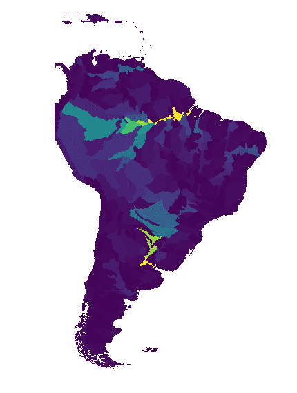
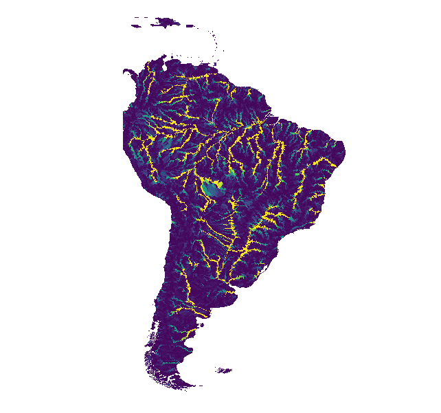
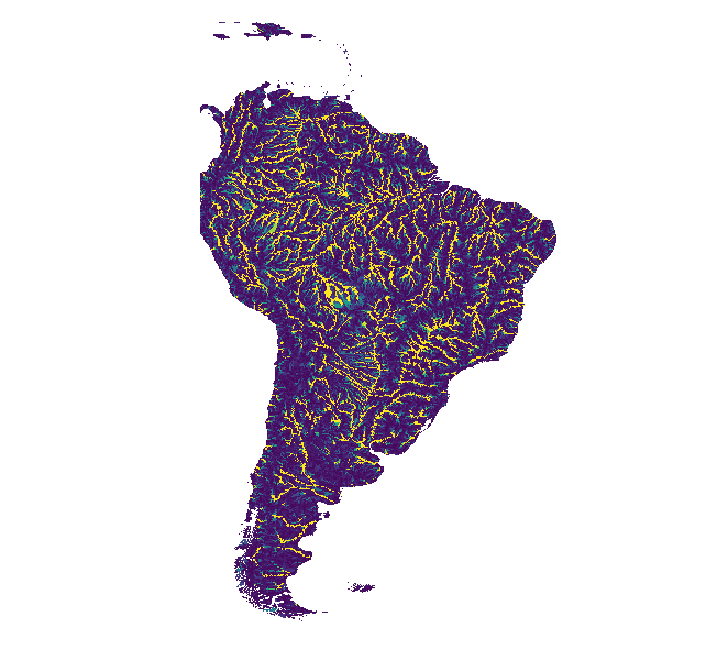
WWF HydroSHEDS Basins Level 1

HydroSHEDS is a mapping product that provides hydrographic information for regional and global-scale applications in a consistent format. It offers a suite of geo-referenced datasets (vector and raster) at various scales, including river networks, watershed boundaries, drainage directions, and flow accumulations. HydroSHEDS is based on … geophysical hydrography hydrology hydrosheds srtm surface-ground-water -
WWF HydroSHEDS Basins Level 10

HydroSHEDS is a mapping product that provides hydrographic information for regional and global-scale applications in a consistent format. It offers a suite of geo-referenced datasets (vector and raster) at various scales, including river networks, watershed boundaries, drainage directions, and flow accumulations. HydroSHEDS is based on … geophysical hydrography hydrology hydrosheds srtm surface-ground-water -
WWF HydroSHEDS Basins Level 11

HydroSHEDS is a mapping product that provides hydrographic information for regional and global-scale applications in a consistent format. It offers a suite of geo-referenced datasets (vector and raster) at various scales, including river networks, watershed boundaries, drainage directions, and flow accumulations. HydroSHEDS is based on … geophysical hydrography hydrology hydrosheds srtm surface-ground-water -
WWF HydroSHEDS Basins Level 12

HydroSHEDS is a mapping product that provides hydrographic information for regional and global-scale applications in a consistent format. It offers a suite of geo-referenced datasets (vector and raster) at various scales, including river networks, watershed boundaries, drainage directions, and flow accumulations. HydroSHEDS is based on … geophysical hydrography hydrology hydrosheds srtm surface-ground-water -
WWF HydroSHEDS Basins Level 2

HydroSHEDS is a mapping product that provides hydrographic information for regional and global-scale applications in a consistent format. It offers a suite of geo-referenced datasets (vector and raster) at various scales, including river networks, watershed boundaries, drainage directions, and flow accumulations. HydroSHEDS is based on … geophysical hydrography hydrology hydrosheds srtm surface-ground-water -
WWF HydroSHEDS Basins Level 3

HydroSHEDS is a mapping product that provides hydrographic information for regional and global-scale applications in a consistent format. It offers a suite of geo-referenced datasets (vector and raster) at various scales, including river networks, watershed boundaries, drainage directions, and flow accumulations. HydroSHEDS is based on … geophysical hydrography hydrology hydrosheds srtm surface-ground-water -
WWF HydroSHEDS Basins Level 4

HydroSHEDS is a mapping product that provides hydrographic information for regional and global-scale applications in a consistent format. It offers a suite of geo-referenced datasets (vector and raster) at various scales, including river networks, watershed boundaries, drainage directions, and flow accumulations. HydroSHEDS is based on … geophysical hydrography hydrology hydrosheds srtm surface-ground-water -
WWF HydroSHEDS Basins Level 5

HydroSHEDS is a mapping product that provides hydrographic information for regional and global-scale applications in a consistent format. It offers a suite of geo-referenced datasets (vector and raster) at various scales, including river networks, watershed boundaries, drainage directions, and flow accumulations. HydroSHEDS is based on … geophysical hydrography hydrology hydrosheds srtm surface-ground-water -
WWF HydroSHEDS Basins Level 6

HydroSHEDS is a mapping product that provides hydrographic information for regional and global-scale applications in a consistent format. It offers a suite of geo-referenced datasets (vector and raster) at various scales, including river networks, watershed boundaries, drainage directions, and flow accumulations. HydroSHEDS is based on … geophysical hydrography hydrology hydrosheds srtm surface-ground-water -
WWF HydroSHEDS Basins Level 7

HydroSHEDS is a mapping product that provides hydrographic information for regional and global-scale applications in a consistent format. It offers a suite of geo-referenced datasets (vector and raster) at various scales, including river networks, watershed boundaries, drainage directions, and flow accumulations. HydroSHEDS is based on … geophysical hydrography hydrology hydrosheds srtm surface-ground-water -
WWF HydroSHEDS Basins Level 8

HydroSHEDS is a mapping product that provides hydrographic information for regional and global-scale applications in a consistent format. It offers a suite of geo-referenced datasets (vector and raster) at various scales, including river networks, watershed boundaries, drainage directions, and flow accumulations. HydroSHEDS is based on … geophysical hydrography hydrology hydrosheds srtm surface-ground-water -
WWF HydroSHEDS Basins Level 9
HydroSHEDS is a mapping product that provides hydrographic information for regional and global-scale applications in a consistent format. It offers a suite of geo-referenced datasets (vector and raster) at various scales, including river networks, watershed boundaries, drainage directions, and flow accumulations. HydroSHEDS is based on … geophysical hydrography hydrology hydrosheds srtm surface-ground-water