

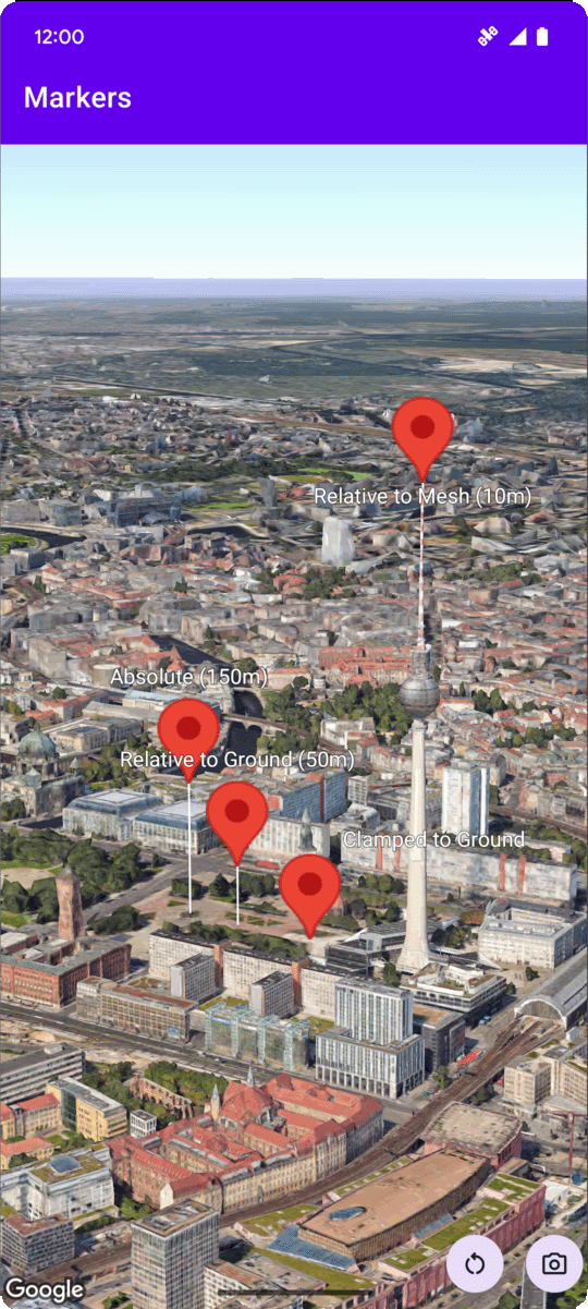
You can set a marker's altitude
by
setting the altitudeMode
property to one of the following values:
-
ABSOLUTE -
RELATIVE_TO_GROUND -
CLAMP_TO_GROUND -
RELATIVE_TO_MESH
The following code sample demonstrates how to use each of the methods. To use
this code sample, follow the instructions in Setup
and Add a 3D map to your
app
to set up your
Android Studio project with a basic 3D map. Then, add the following code to the MainActivity.kt
file:
 // Add imports

 import

 com.google.android.gms.maps3d.model.latLngAltitude


 ...


 // Add to the onMap3DViewReady method, after the googleMap3D object has been initialized

 googleMap3D
 .
 setMapMode
 (
 Map3DMode
 .
 SATELLITE
 )


 googleMap3D
 .
 setCamera
 (

 camera

 {

 center

 =

 latLngAltitude

 {

 latitude

 =

 52.51974795

 longitude

 =

 13.40715553

 altitude

 =

 150.0

 }

 heading

 =

 252.7

 tilt

 =

 79.0

 range

 =

 1500.0

 }

 )


 // Marker 1: Absolute

 googleMap3D
 .
 addMarker
 (
 markerOptions

 {

 position

 =

 latLngAltitude

 {

 latitude

 =

 52.519605780912585

 longitude

 =

 13.406867190588198

 altitude

 =

 150.0

 }

 label

 =

 "Absolute (150m)"

 altitudeMode

 =

 AltitudeMode
 .
 ABSOLUTE

 isExtruded

 =

 true

 isDrawnWhenOccluded

 =

 true

 collisionBehavior

 =

 CollisionBehavior
 .
 REQUIRED_AND_HIDES_OPTIONAL

 })


 // Marker 2: Relative to Ground

 googleMap3D
 .
 addMarker
 (
 markerOptions

 {

 position

 =

 latLngAltitude

 {

 latitude

 =

 52.519882191069016

 longitude

 =

 13.407410777254293

 altitude

 =

 50.0

 }

 label

 =

 "Relative to Ground (50m)"

 altitudeMode

 =

 AltitudeMode
 .
 RELATIVE_TO_GROUND

 isExtruded

 =

 true

 isDrawnWhenOccluded

 =

 true

 })


 // Marker 3: Clamped to Ground

 googleMap3D
 .
 addMarker
 (
 markerOptions

 {

 position

 =

 latLngAltitude

 {

 latitude

 =

 52.52027645136134

 longitude

 =

 13.408271658592406

 altitude

 =

 0.0

 // altitude is effectively ignored by CLAMP_TO_GROUND for rendering,

 // but might be relevant if you read the marker's position later.

 // For CLAMP_TO_GROUND, it's often set to 0.0.

 }

 label

 =

 "Clamped to Ground"

 altitudeMode

 =

 AltitudeMode
 .
 CLAMP_TO_GROUND

 isExtruded

 =

 true

 isDrawnWhenOccluded

 =

 true

 })


 // Marker 4: Relative to Mesh

 googleMap3D
 .
 addMarker
 (
 markerOptions

 {

 position

 =

 latLngAltitude

 {

 latitude

 =

 52.520835071144226

 longitude

 =

 13.409426847943774

 altitude

 =

 10.0

 // Altitude relative to 3D mesh (buildings, terrain features)

 }

 label

 =

 "Relative to Mesh (10m)"

 altitudeMode

 =

 AltitudeMode
 .
 RELATIVE_TO_MESH

 isExtruded

 =

 true

 isDrawnWhenOccluded

 =

 true

 })