
Page Summary
-
The Ocean and Land Color Instrument (OLCI) dataset provides top of atmosphere radiances in 21 spectral bands with a 300m spatial resolution.
-
This dataset offers worldwide coverage approximately every two days and is available from late 2016 to late 2025.
-
OLCI is part of the Sentinel-3 mission, designed to support ocean forecasting and environmental and climate monitoring.
-
The data includes quality flags and various image properties providing information about processing, product details, orbit, and pixel quality.
-
Use of the data is governed by the Copernicus Sentinel Data Terms and Conditions.
- Dataset Availability
- 2016-10-18T19:25:42Z–2026-06-12T08:52:04Z
- Dataset Producer
- European Union/ESA/Copernicus
- Revisit Interval
- 2 Days
- Tags
Description
The Ocean and Land Color Instrument (OLCI) Earth Observation Full Resolution (EFR) dataset contains top of atmosphere radiances at 21 spectral bands with center wavelengths ranging between 0.4µm and 1.02µm at spatial resolution of 300m with worldwide coverage every ~2 days.
OLCI is one of the instruments in the ESA/EUMETSAT Sentinel-3 mission for measuring sea-surface topography, sea- and land-surface temperature, ocean color and land color with high-end accuracy and reliability to support ocean forecasting systems, as well as environmental and climate monitoring.
The Sentinel-3 OLCI instrument is based on the optomechanical and imaging design of ENVISAT's MERIS. It is designed to retrieve the spectral distribution of upwelling radiance just above the sea surface (the water-leaving radiance).
OLCI observation is performed simultaneously in 21 spectral bands ranging from the visible to the near-infrared (400 to 1029 nm).
Bands
Bands
Pixel size: 300 meters (all bands)
Oa01_radiance
Aerosol correction, improved water constituent retrieval
Oa02_radiance
Yellow substance and detrital pigments (turbidity)
Oa03_radiance
Chl absorption max., biogeochemistry, vegetation
Oa04_radiance
High Chl, other pigments
Oa05_radiance
Chl, sediment, turbidity, red tide
Oa06_radiance
Chlorophyll reference (Chl minimum)
Oa07_radiance
Sediment loading
Oa08_radiance
Chl (2^nd Chl abs. max.), sediment, yellow substance/vegetation
Oa09_radiance
For improved fluorescence retrieval and to better account for smile together with the bands 665 and 680nm
Oa10_radiance
Chl fluorescence peak, red edge
Oa11_radiance
Chl fluorescence baseline, red edge transition
Oa12_radiance
O2 absorption/clouds, vegetation
Oa13_radiance
O2 absorption band/aerosol correction
Oa14_radiance
Atmospheric correction
Oa15_radiance
O2A used for cloud top pressure, fluorescence over land
Oa16_radiance
Atmospheric correction/aerosol correction
Oa17_radiance
Atmospheric correction/aerosol correction, clouds, pixel co-registration
Oa18_radiance
Water vapor absorption reference band. Common reference band with SLSTR instrument. Vegetation monitoring
Oa19_radiance
Water vapor absorption/vegetation monitoring (max. reflectance)
Oa20_radiance
Water vapor absorption, atmospheric/aerosol correction
Oa21_radiance
Atmospheric/aerosol correction
quality_flags
Quality flags
Image Properties
Image Properties
| Name | Type | Description |
|---|---|---|
|
SNAP_Graph_Processing_Framework_GPF_vers
|
STRING | Sentinel Application Platform (SNAP) version |
|
SNAP_Raster_Operators_vers
|
STRING | SNAP version |
|
processing_facility_country
|
STRING | Name of the country where the facility is located. This element is configurable within the IPF. |
|
processing_facility_name
|
STRING | Name of the facility where the processing step was performed. This element is configurable within the IPF. |
|
processing_facility_organisation
|
STRING | Name of the organisation responsible for the facility. This element is configurable within the IPF. |
|
processing_facility_site
|
STRING | Geographical location of the facility. This element is configurable within the IPF. |
|
processing_hardware
|
STRING | Name of the hardware in the facility used for the processing. |
|
processing_software_name
|
STRING | Name of the software component. |
|
processing_software_version
|
DOUBLE | The version or release identifier of the software |
|
processing_time
|
DOUBLE | The time the product was processed in 'epoch' format |
|
product
|
STRING | This is always |
|
PRODUCT_ID
|
STRING | The full id of the original Sentinel-3 product |
|
productQuality
|
STRING | PASSED or empty |
|
cycle_num
|
DOUBLE | The cycle number is the number of times the satellite passed over the same geographical point on the ground. In the SENTINEL-3 operational phase (after launch and commissioning phases), the orbit cycle is 27 days. |
|
orbitNumber
|
DOUBLE | The absolute orbit number considers the orbits elapsed since the first ascending node crossing after launch. |
|
relative_orbit_num
|
DOUBLE | The relative orbit number is the orbit number within a cycle. Every time a cycle starts, the relative orbit number is reset to zero. |
|
groundTrackDirection
|
STRING | Direction of the trace made by the sub-satellite point on the surface of the Earth's reference ellipsoid due to the motion of the satellite along its orbit. |
|
spacecraft
|
STRING | Sentinel-3 spacecraft name: S3A, S3B |
|
status
|
STRING | Status of the file |
|
timeliness
|
STRING | Timeliness of processing being analysed |
|
salineWaterPixelsPercent
|
DOUBLE | Pixel quality information |
|
coastalPixelsPercent
|
DOUBLE | Pixel quality information |
|
freshInlandWaterPixelsPercent
|
DOUBLE | Pixel quality information |
|
tidalRegionPixelsPercent
|
DOUBLE | Pixel quality information |
|
brightPixelsPercent
|
DOUBLE | Pixel quality information |
|
invalidPixelsPercent
|
DOUBLE | Pixel quality information |
|
cosmeticPixelsPercent
|
DOUBLE | Pixel quality information |
|
duplicatedPixelsPercent
|
DOUBLE | Pixel quality information |
|
dubiousSamplesPercent
|
DOUBLE | Pixel quality information |
|
saturatedPixelsPercent
|
DOUBLE | Pixel quality information |
Terms of Use
Terms of Use
The use of Sentinel data is governed by the Copernicus Sentinel Data Terms and Conditions.
Explore with Earth Engine
Code Editor (JavaScript)
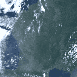
 var

 dataset

 =

 ee
 .
 ImageCollection
 (
 'COPERNICUS/S3/OLCI'
 )

 .
 filterDate
 (
 '2018-04-01'
 ,

 '2018-04-04'
 );
 // Select bands for visualization and apply band-specific scale factors.
 var

 rgb

 =

 dataset
 .
 select
 ([
 'Oa08_radiance'
 ,

 'Oa06_radiance'
 ,

 'Oa04_radiance'
 ])

 .
 median
 ()

 // Convert to radiance units.

 .
 multiply
 (
 ee
 .
 Image
 ([
 0.00876539
 ,

 0.0123538
 ,

 0.0115198
 ]));
 var

 visParams

 =

 {

 min
 :

 0
 ,

 max
 :

 6
 ,

 gamma
 :

 1.5
 ,
 };
 Map
 .
 setCenter
 (
 46.043
 ,

 1.45
 ,

 5
 );
 Map
 .
 addLayer
 (
 rgb
 ,

 visParams
 ,

 'RGB'
 );
 import

 ee
 import

 geemap.core

 as

 geemap
Colab (Python)
 dataset
 =
 ee
 .
 ImageCollection
 (
 'COPERNICUS/S3/OLCI'
 )
 .
 filterDate
 (
 '2018-04-01'
 ,
 '2018-04-04'
 )
 # Select bands for visualization and apply band-specific scale factors.
 rgb
 =
 (
 dataset
 .
 select
 ([
 'Oa08_radiance'
 ,
 'Oa06_radiance'
 ,
 'Oa04_radiance'
 ])
 .
 median
 ()
 .
 multiply
 (
 ee
 .
 Image
 ([
 0.00876539
 ,
 0.0123538
 ,
 0.0115198
 ]))
 )
 # Convert to radiance units.
 vis_params
 =
 {
 'min'
 :
 0
 ,
 'max'
 :
 6
 ,
 'gamma'
 :
 1.5
 }
 m
 =
 geemap
 .
 Map
 ()
 m
 .
 set_center
 (
 46.043
 ,
 1.45
 ,
 5
 )
 m
 .
 add_layer
 (
 rgb
 ,
 vis_params
 ,
 'RGB'
 )
 m