
Page Summary
-
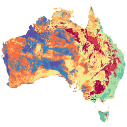
The Soil and Landscape Grid of Australia (SLGA) dataset provides comprehensive soil attribute information for Australia at approximately 90m resolution.
-
The dataset includes digital soil attribute maps and their confidence limits for six different depths.
-
The SLGA dataset is available from 1950 to 2013 and is provided by CSIRO.
-
The data is licensed under a Creative Commons Attribution License (CC BY) and is free to use for research, education, and nonprofit purposes with registration for Earth Engine access.
- Dataset Availability
- 1950-01-01T00:00:00Z–2013-12-31T00:00:00Z
- Dataset Producer
- CSIRO/SLGA
- Tags
Description
The Soil and Landscape Grid of Australia (SLGA) is a comprehensive dataset of soil attributes across Australia at 3 arc-second resolution (~90m pixels). The surfaces are the outcomes from modelling that describe the spatial distribution of the soil attributes using existing soil data and environmental covariates. See Viscarra Rossel et al (2015) for further details. The SLGA can be used in studies of vadose zone processes, including solute transport, groundwater and nutrient fluxes beyond the root zone, as well as a wide spectrum of ecological, hydrological, and broader environmental applications.
Each product contains six digital soil attribute maps and their upper and lower confidence limits, representing the soil attribute at six depths: 0-5cm, 5-15cm, 15-30cm, 30-60cm, 60-100cm, and 100-200cm. These depths and soil attributes are consistent with the specifications of GlobalSoilMap .
This collection has 12 images. Ten of them contain data for GSM primary soil attributes; the other two contain regolith depth and soil depth GSM attributes.
| Attribute | Description | Code | # of Bands |
|---|---|---|---|
|
Bulk Density (whole earth)
|
Bulk density of the whole soil (including coarse fragments) in mass per unit volume by a method equivalent to the core method | BDW | 18 |
|
Organic Carbon
|
Mass fraction of carbon by weight in the < 2mm soil material as determined by dry combustion at 900 Celsius | SOC | 18 |
|
Clay
|
< 2µm mass fraction of the <2mm soil material determined using the pipette method | CLY | 18 |
|
Silt
|
2-20µm mass fraction of the < 2mm soil material determined using the pipette method | SLT | 18 |
|
Sand
|
20µm - 2mm mass fraction of the < 2mm soil material determined using the pipette method | SND | 18 |
|
pH (CaCl2)
|
pH of 1:5 soil/0.01M calcium chloride extract | pHc | 18 |
|
Available Water Capacity
|
Available water capacity computed for each of the specified depth increments | AWC | 18 |
|
Total Nitrogen
|
Mass fraction of total nitrogen in the soil by weight | NTO | 18 |
|
Total Phosphorus
|
Mass fraction of total phosphorus in the soil by weight | PTO | 18 |
|
Effective Cation Exchange Capacity
|
Cations extracted using barium chloride (BaCl2) plus exchangeable H + Al | ECE | 18 |
|
Depth of Regolith
|
Depth to hard rock. Depth is inclusive of all regolith. | DER | 3 |
|
Depth of Soil
|
Depth of soil profile (A & B horizons) | DES | 3 |
Bands
Bands
Pixel size: 92.77 meters (all bands)
| Name | Units | Pixel Size | Description |
|---|---|---|---|
AWC_000_005_EV
|
% | 92.77 meters | The soil attribute's estimated value at depth 0-5cm |
AWC_000_005_05
|
% | 92.77 meters | The soil attribute's 5th percentile confidence limit at depth 0-5cm |
AWC_000_005_95
|
% | 92.77 meters | The soil attribute's 95th percentile confidence limit at depth 0-5cm |
AWC_005_015_EV
|
% | 92.77 meters | The soil attribute's estimated value at depth 5-15cm |
AWC_005_015_05
|
% | 92.77 meters | The soil attribute's 5th percentile confidence limit at depth 5-15cm |
AWC_005_015_95
|
% | 92.77 meters | The soil attribute's 95th percentile confidence limit at depth 5-15cm |
AWC_015_030_EV
|
% | 92.77 meters | The soil attribute's estimated value at depth 15-30cm |
AWC_015_030_05
|
% | 92.77 meters | The soil attribute's 5th percentile confidence limit at depth 15-30cm |
AWC_015_030_95
|
% | 92.77 meters | The soil attribute's 95th percentile confidence limit at depth 15-30cm |
AWC_030_060_EV
|
% | 92.77 meters | The soil attribute's estimated value at depth 30-60cm |
AWC_030_060_05
|
% | 92.77 meters | The soil attribute's 5th percentile confidence limit at depth 30-60cm |
AWC_030_060_95
|
% | 92.77 meters | The soil attribute's 95th percentile confidence limit at depth 30-60cm |
AWC_060_100_EV
|
% | 92.77 meters | The soil attribute's estimated value at depth 60-100cm |
AWC_060_100_05
|
% | 92.77 meters | The soil attribute's 5th percentile confidence limit at depth 60-100cm |
AWC_060_100_95
|
% | 92.77 meters | The soil attribute's 95th percentile confidence limit at depth 60-100cm |
AWC_100_200_EV
|
% | 92.77 meters | The soil attribute's estimated value at depth 100-200cm |
AWC_100_200_05
|
% | 92.77 meters | The soil attribute's 5th percentile confidence limit at depth 100-200cm |
AWC_100_200_95
|
% | 92.77 meters | The soil attribute's 95th percentile confidence limit at depth 100-200cm |
BDW_000_005_EV
|
g/cm^3 | 92.77 meters | The soil attribute's estimated value at depth 0-5cm |
BDW_000_005_05
|
g/cm^3 | 92.77 meters | The soil attribute's 5th percentile confidence limit at depth 0-5cm |
BDW_000_005_95
|
g/cm^3 | 92.77 meters | The soil attribute's 95th percentile confidence limit at depth 0-5cm |
BDW_005_015_EV
|
g/cm^3 | 92.77 meters | The soil attribute's estimated value at depth 5-15cm |
BDW_005_015_05
|
g/cm^3 | 92.77 meters | The soil attribute's 5th percentile confidence limit at depth 5-15cm |
BDW_005_015_95
|
g/cm^3 | 92.77 meters | The soil attribute's 95th percentile confidence limit at depth 5-15cm |
BDW_015_030_EV
|
g/cm^3 | 92.77 meters | The soil attribute's estimated value at depth 15-30cm |
BDW_015_030_05
|
g/cm^3 | 92.77 meters | The soil attribute's 5th percentile confidence limit at depth 15-30cm |
BDW_015_030_95
|
g/cm^3 | 92.77 meters | The soil attribute's 95th percentile confidence limit at depth 15-30cm |
BDW_030_060_EV
|
g/cm^3 | 92.77 meters | The soil attribute's estimated value at depth 30-60cm |
BDW_030_060_05
|
g/cm^3 | 92.77 meters | The soil attribute's 5th percentile confidence limit at depth 30-60cm |
BDW_030_060_95
|
g/cm^3 | 92.77 meters | The soil attribute's 95th percentile confidence limit at depth 30-60cm |
BDW_060_100_EV
|
g/cm^3 | 92.77 meters | The soil attribute's estimated value at depth 60-100cm |
BDW_060_100_05
|
g/cm^3 | 92.77 meters | The soil attribute's 5th percentile confidence limit at depth 60-100cm |
BDW_060_100_95
|
g/cm^3 | 92.77 meters | The soil attribute's 95th percentile confidence limit at depth 60-100cm |
BDW_100_200_EV
|
g/cm^3 | 92.77 meters | The soil attribute's estimated value at depth 100-200cm |
BDW_100_200_05
|
g/cm^3 | 92.77 meters | The soil attribute's 5th percentile confidence limit at depth 100-200cm |
BDW_100_200_95
|
g/cm^3 | 92.77 meters | The soil attribute's 95th percentile confidence limit at depth 100-200cm |
CLY_000_005_EV
|
% | 92.77 meters | The soil attribute's estimated value at depth 0-5cm |
CLY_000_005_05
|
% | 92.77 meters | The soil attribute's 5th percentile confidence limit at depth 0-5cm |
CLY_000_005_95
|
% | 92.77 meters | The soil attribute's 95th percentile confidence limit at depth 0-5cm |
CLY_005_015_EV
|
% | 92.77 meters | The soil attribute's estimated value at depth 5-15cm |
CLY_005_015_05
|
% | 92.77 meters | The soil attribute's 5th percentile confidence limit at depth 5-15cm |
CLY_005_015_95
|
% | 92.77 meters | The soil attribute's 95th percentile confidence limit at depth 5-15cm |
CLY_015_030_EV
|
% | 92.77 meters | The soil attribute's estimated value at depth 15-30cm |
CLY_015_030_05
|
% | 92.77 meters | The soil attribute's 5th percentile confidence limit at depth 15-30cm |
CLY_015_030_95
|
% | 92.77 meters | The soil attribute's 95th percentile confidence limit at depth 15-30cm |
CLY_030_060_EV
|
% | 92.77 meters | The soil attribute's estimated value at depth 30-60cm |
CLY_030_060_05
|
% | 92.77 meters | The soil attribute's 5th percentile confidence limit at depth 30-60cm |
CLY_030_060_95
|
% | 92.77 meters | The soil attribute's 95th percentile confidence limit at depth 30-60cm |
CLY_060_100_EV
|
% | 92.77 meters | The soil attribute's estimated value at depth 60-100cm |
CLY_060_100_05
|
% | 92.77 meters | The soil attribute's 5th percentile confidence limit at depth 60-100cm |
CLY_060_100_95
|
% | 92.77 meters | The soil attribute's 95th percentile confidence limit at depth 60-100cm |
CLY_100_200_EV
|
% | 92.77 meters | The soil attribute's estimated value at depth 100-200cm |
CLY_100_200_05
|
% | 92.77 meters | The soil attribute's 5th percentile confidence limit at depth 100-200cm |
CLY_100_200_95
|
% | 92.77 meters | The soil attribute's 95th percentile confidence limit at depth 100-200cm |
DER_000_200_EV
|
m | 92.77 meters | The estimated value for the regolith depth |
DER_000_200_05
|
m | 92.77 meters | The 5th percentile confidence limit for the regolith depth |
DER_000_200_95
|
m | 92.77 meters | The 95th percentile confidence limit for the regolith depth |
DES_000_200_EV
|
m | 92.77 meters | The estimated value for the soil depth |
DES_000_200_05
|
m | 92.77 meters | The 5th percentile confidence limit for the soil depth |
DES_000_200_95
|
m | 92.77 meters | The 5th percentile confidence limit for the soil depth |
ECE_000_005_EV
|
meq/100g | 92.77 meters | The soil attribute's estimated value at depth 0-5cm |
ECE_000_005_05
|
meq/100g | 92.77 meters | The soil attribute's 5th percentile confidence limit at depth 0-5cm |
ECE_000_005_95
|
meq/100g | 92.77 meters | The soil attribute's 95th percentile confidence limit at depth 0-5cm |
ECE_005_015_EV
|
meq/100g | 92.77 meters | The soil attribute's estimated value at depth 5-15cm |
ECE_005_015_05
|
meq/100g | 92.77 meters | The soil attribute's 5th percentile confidence limit at depth 5-15cm |
ECE_005_015_95
|
meq/100g | 92.77 meters | The soil attribute's 95th percentile confidence limit at depth 5-15cm |
ECE_015_030_EV
|
meq/100g | 92.77 meters | The soil attribute's estimated value at depth 15-30cm |
ECE_015_030_05
|
meq/100g | 92.77 meters | The soil attribute's 5th percentile confidence limit at depth 15-30cm |
ECE_015_030_95
|
meq/100g | 92.77 meters | The soil attribute's 95th percentile confidence limit at depth 15-30cm |
ECE_030_060_EV
|
meq/100g | 92.77 meters | The soil attribute's estimated value at depth 30-60cm |
ECE_030_060_05
|
meq/100g | 92.77 meters | The soil attribute's 5th percentile confidence limit at depth 30-60cm |
ECE_030_060_95
|
meq/100g | 92.77 meters | The soil attribute's 95th percentile confidence limit at depth 30-60cm |
ECE_060_100_EV
|
meq/100g | 92.77 meters | The soil attribute's estimated value at depth 60-100cm |
ECE_060_100_05
|
meq/100g | 92.77 meters | The soil attribute's 5th percentile confidence limit at depth 60-100cm |
ECE_060_100_95
|
meq/100g | 92.77 meters | The soil attribute's 95th percentile confidence limit at depth 60-100cm |
ECE_100_200_EV
|
meq/100g | 92.77 meters | The soil attribute's estimated value at depth 100-200cm |
ECE_100_200_05
|
meq/100g | 92.77 meters | The soil attribute's 5th percentile confidence limit at depth 100-200cm |
ECE_100_200_95
|
meq/100g | 92.77 meters | The soil attribute's 95th percentile confidence limit at depth 100-200cm |
NTO_000_005_EV
|
% | 92.77 meters | The soil attribute's estimated value at depth 0-5cm |
NTO_000_005_05
|
% | 92.77 meters | The soil attribute's 5th percentile confidence limit at depth 0-5cm |
NTO_000_005_95
|
% | 92.77 meters | The soil attribute's 95th percentile confidence limit at depth 0-5cm |
NTO_005_015_EV
|
% | 92.77 meters | The soil attribute's estimated value at depth 5-15cm |
NTO_005_015_05
|
% | 92.77 meters | The soil attribute's 5th percentile confidence limit at depth 5-15cm |
NTO_005_015_95
|
% | 92.77 meters | The soil attribute's 95th percentile confidence limit at depth 5-15cm |
NTO_015_030_EV
|
% | 92.77 meters | The soil attribute's estimated value at depth 15-30cm |
NTO_015_030_05
|
% | 92.77 meters | The soil attribute's 5th percentile confidence limit at depth 15-30cm |
NTO_015_030_95
|
% | 92.77 meters | The soil attribute's 95th percentile confidence limit at depth 15-30cm |
NTO_030_060_EV
|
% | 92.77 meters | The soil attribute's estimated value at depth 30-60cm |
NTO_030_060_05
|
% | 92.77 meters | The soil attribute's 5th percentile confidence limit at depth 30-60cm |
NTO_030_060_95
|
% | 92.77 meters | The soil attribute's 95th percentile confidence limit at depth 30-60cm |
NTO_060_100_EV
|
% | 92.77 meters | The soil attribute's estimated value at depth 60-100cm |
NTO_060_100_05
|
% | 92.77 meters | The soil attribute's 5th percentile confidence limit at depth 60-100cm |
NTO_060_100_95
|
% | 92.77 meters | The soil attribute's 95th percentile confidence limit at depth 60-100cm |
NTO_100_200_EV
|
% | 92.77 meters | The soil attribute's estimated value at depth 100-200cm |
NTO_100_200_05
|
% | 92.77 meters | The soil attribute's 5th percentile confidence limit at depth 100-200cm |
NTO_100_200_95
|
% | 92.77 meters | The soil attribute's 95th percentile confidence limit at depth 100-200cm |
pHc_000_005_EV
|
92.77 meters | The soil attribute's estimated value at depth 0-5cm |
|
pHc_000_005_05
|
92.77 meters | The soil attribute's 5th percentile confidence limit at depth 0-5cm |
|
pHc_000_005_95
|
92.77 meters | The soil attribute's 95th percentile confidence limit at depth 0-5cm |
|
pHc_005_015_EV
|
92.77 meters | The soil attribute's estimated value at depth 5-15cm |
|
pHc_005_015_05
|
92.77 meters | The soil attribute's 5th percentile confidence limit at depth 5-15cm |
|
pHc_005_015_95
|
92.77 meters | The soil attribute's 95th percentile confidence limit at depth 5-15cm |
|
pHc_015_030_EV
|
92.77 meters | The soil attribute's estimated value at depth 15-30cm |
|
pHc_015_030_05
|
92.77 meters | The soil attribute's 5th percentile confidence limit at depth 15-30cm |
|
pHc_015_030_95
|
92.77 meters | The soil attribute's 95th percentile confidence limit at depth 15-30cm |
|
pHc_030_060_EV
|
92.77 meters | The soil attribute's estimated value at depth 30-60cm |
|
pHc_030_060_05
|
92.77 meters | The soil attribute's 5th percentile confidence limit at depth 30-60cm |
|
pHc_030_060_95
|
92.77 meters | The soil attribute's 95th percentile confidence limit at depth 30-60cm |
|
pHc_060_100_EV
|
92.77 meters | The soil attribute's estimated value at depth 60-100cm |
|
pHc_060_100_05
|
92.77 meters | The soil attribute's 5th percentile confidence limit at depth 60-100cm |
|
pHc_060_100_95
|
92.77 meters | The soil attribute's 95th percentile confidence limit at depth 60-100cm |
|
pHc_100_200_EV
|
92.77 meters | The soil attribute's estimated value at depth 100-200cm |
|
pHc_100_200_05
|
92.77 meters | The soil attribute's 5th percentile confidence limit at depth 100-200cm |
|
pHc_100_200_95
|
92.77 meters | The soil attribute's 95th percentile confidence limit at depth 100-200cm |
|
PTO_000_005_EV
|
% | 92.77 meters | The soil attribute's estimated value at depth 0-5cm |
PTO_000_005_05
|
% | 92.77 meters | The soil attribute's 5th percentile confidence limit at depth 0-5cm |
PTO_000_005_95
|
% | 92.77 meters | The soil attribute's 95th percentile confidence limit at depth 0-5cm |
PTO_005_015_EV
|
% | 92.77 meters | The soil attribute's estimated value at depth 5-15cm |
PTO_005_015_05
|
% | 92.77 meters | The soil attribute's 5th percentile confidence limit at depth 5-15cm |
PTO_005_015_95
|
% | 92.77 meters | The soil attribute's 95th percentile confidence limit at depth 5-15cm |
PTO_015_030_EV
|
% | 92.77 meters | The soil attribute's estimated value at depth 15-30cm |
PTO_015_030_05
|
% | 92.77 meters | The soil attribute's 5th percentile confidence limit at depth 15-30cm |
PTO_015_030_95
|
% | 92.77 meters | The soil attribute's 95th percentile confidence limit at depth 15-30cm |
PTO_030_060_EV
|
% | 92.77 meters | The soil attribute's estimated value at depth 30-60cm |
PTO_030_060_05
|
% | 92.77 meters | The soil attribute's 5th percentile confidence limit at depth 30-60cm |
PTO_030_060_95
|
% | 92.77 meters | The soil attribute's 95th percentile confidence limit at depth 30-60cm |
PTO_060_100_EV
|
% | 92.77 meters | The soil attribute's estimated value at depth 60-100cm |
PTO_060_100_05
|
% | 92.77 meters | The soil attribute's 5th percentile confidence limit at depth 60-100cm |
PTO_060_100_95
|
% | 92.77 meters | The soil attribute's 95th percentile confidence limit at depth 60-100cm |
PTO_100_200_EV
|
% | 92.77 meters | The soil attribute's estimated value at depth 100-200cm |
PTO_100_200_05
|
% | 92.77 meters | The soil attribute's 5th percentile confidence limit at depth 100-200cm |
PTO_100_200_95
|
% | 92.77 meters | The soil attribute's 95th percentile confidence limit at depth 100-200cm |
SLT_000_005_EV
|
% | 92.77 meters | The soil attribute's estimated value at depth 0-5cm |
SLT_000_005_05
|
% | 92.77 meters | The soil attribute's 5th percentile confidence limit at depth 0-5cm |
SLT_000_005_95
|
% | 92.77 meters | The soil attribute's 95th percentile confidence limit at depth 0-5cm |
SLT_005_015_EV
|
% | 92.77 meters | The soil attribute's estimated value at depth 5-15cm |
SLT_005_015_05
|
% | 92.77 meters | The soil attribute's 5th percentile confidence limit at depth 5-15cm |
SLT_005_015_95
|
% | 92.77 meters | The soil attribute's 95th percentile confidence limit at depth 5-15cm |
SLT_015_030_EV
|
% | 92.77 meters | The soil attribute's estimated value at depth 15-30cm |
SLT_015_030_05
|
% | 92.77 meters | The soil attribute's 5th percentile confidence limit at depth 15-30cm |
SLT_015_030_95
|
% | 92.77 meters | The soil attribute's 95th percentile confidence limit at depth 15-30cm |
SLT_030_060_EV
|
% | 92.77 meters | The soil attribute's estimated value at depth 30-60cm |
SLT_030_060_05
|
% | 92.77 meters | The soil attribute's 5th percentile confidence limit at depth 30-60cm |
SLT_030_060_95
|
% | 92.77 meters | The soil attribute's 95th percentile confidence limit at depth 30-60cm |
SLT_060_100_EV
|
% | 92.77 meters | The soil attribute's estimated value at depth 60-100cm |
SLT_060_100_05
|
% | 92.77 meters | The soil attribute's 5th percentile confidence limit at depth 60-100cm |
SLT_060_100_95
|
% | 92.77 meters | The soil attribute's 95th percentile confidence limit at depth 60-100cm |
SLT_100_200_EV
|
% | 92.77 meters | The soil attribute's estimated value at depth 100-200cm |
SLT_100_200_05
|
% | 92.77 meters | The soil attribute's 5th percentile confidence limit at depth 100-200cm |
SLT_100_200_95
|
% | 92.77 meters | The soil attribute's 95th percentile confidence limit at depth 100-200cm |
SND_000_005_EV
|
% | 92.77 meters | The soil attribute's estimated value at depth 0-5cm |
SND_000_005_05
|
% | 92.77 meters | The soil attribute's 5th percentile confidence limit at depth 0-5cm |
SND_000_005_95
|
% | 92.77 meters | The soil attribute's 95th percentile confidence limit at depth 0-5cm |
SND_005_015_EV
|
% | 92.77 meters | The soil attribute's estimated value at depth 5-15cm |
SND_005_015_05
|
% | 92.77 meters | The soil attribute's 5th percentile confidence limit at depth 5-15cm |
SND_005_015_95
|
% | 92.77 meters | The soil attribute's 95th percentile confidence limit at depth 5-15cm |
SND_015_030_EV
|
% | 92.77 meters | The soil attribute's estimated value at depth 15-30cm |
SND_015_030_05
|
% | 92.77 meters | The soil attribute's 5th percentile confidence limit at depth 15-30cm |
SND_015_030_95
|
% | 92.77 meters | The soil attribute's 95th percentile confidence limit at depth 15-30cm |
SND_030_060_EV
|
% | 92.77 meters | The soil attribute's estimated value at depth 30-60cm |
SND_030_060_05
|
% | 92.77 meters | The soil attribute's 5th percentile confidence limit at depth 30-60cm |
SND_030_060_95
|
% | 92.77 meters | The soil attribute's 95th percentile confidence limit at depth 30-60cm |
SND_060_100_EV
|
% | 92.77 meters | The soil attribute's estimated value at depth 60-100cm |
SND_060_100_05
|
% | 92.77 meters | The soil attribute's 5th percentile confidence limit at depth 60-100cm |
SND_060_100_95
|
% | 92.77 meters | The soil attribute's 95th percentile confidence limit at depth 60-100cm |
SND_100_200_EV
|
% | 92.77 meters | The soil attribute's estimated value at depth 100-200cm |
SND_100_200_05
|
% | 92.77 meters | The soil attribute's 5th percentile confidence limit at depth 100-200cm |
SND_100_200_95
|
% | 92.77 meters | The soil attribute's 95th percentile confidence limit at depth 100-200cm |
SOC_000_005_EV
|
% | 92.77 meters | The soil attribute's estimated value at depth 0-5cm |
SOC_000_005_05
|
% | 92.77 meters | The soil attribute's 5th percentile confidence limit at depth 0-5cm |
SOC_000_005_95
|
% | 92.77 meters | The soil attribute's 95th percentile confidence limit at depth 0-5cm |
SOC_005_015_EV
|
% | 92.77 meters | The soil attribute's estimated value at depth 5-15cm |
SOC_005_015_05
|
% | 92.77 meters | The soil attribute's 5th percentile confidence limit at depth 5-15cm |
SOC_005_015_95
|
% | 92.77 meters | The soil attribute's 95th percentile confidence limit at depth 5-15cm |
SOC_015_030_EV
|
% | 92.77 meters | The soil attribute's estimated value at depth 15-30cm |
SOC_015_030_05
|
% | 92.77 meters | The soil attribute's 5th percentile confidence limit at depth 15-30cm |
SOC_015_030_95
|
% | 92.77 meters | The soil attribute's 95th percentile confidence limit at depth 15-30cm |
SOC_030_060_EV
|
% | 92.77 meters | The soil attribute's estimated value at depth 30-60cm |
SOC_030_060_05
|
% | 92.77 meters | The soil attribute's 5th percentile confidence limit at depth 30-60cm |
SOC_030_060_95
|
% | 92.77 meters | The soil attribute's 95th percentile confidence limit at depth 30-60cm |
SOC_060_100_EV
|
% | 92.77 meters | The soil attribute's estimated value at depth 60-100cm |
SOC_060_100_05
|
% | 92.77 meters | The soil attribute's 5th percentile confidence limit at depth 60-100cm |
SOC_060_100_95
|
% | 92.77 meters | The soil attribute's 95th percentile confidence limit at depth 60-100cm |
SOC_100_200_EV
|
% | 92.77 meters | The soil attribute's estimated value at depth 100-200cm |
SOC_100_200_05
|
% | 92.77 meters | The soil attribute's 5th percentile confidence limit at depth 100-200cm |
SOC_100_200_95
|
% | 92.77 meters | The soil attribute's 95th percentile confidence limit at depth 100-200cm |
Image Properties
Image Properties
| Name | Type | Description |
|---|---|---|
|
anzlic_topic_category
|
STRING | Topic category according to Australia's and New Zealand's Spatial Information Council |
|
contact
|
STRING | General contact |
|
contact_gee_ingestion
|
STRING | Who to contact for issues related to Earth Engine ingestion |
|
contact_lead_researcher
|
STRING | Lead Researcher |
|
contact_project_director
|
STRING | Project Director |
|
contact_project_leader
|
STRING | Project Leader |
|
country
|
STRING | Country this asset covers |
|
country_code
|
STRING | ISO country code |
|
credit
|
STRING | Credit |
|
datatype
|
STRING | 'Numeric Value' or 'Categorical Value' |
|
datatype_code
|
STRING | 'N' or 'C' |
|
date_created
|
DOUBLE | Date of publication |
|
estimate_spatial_support
|
STRING | GSM v2.3 tier 1 or 2, 'P' or 'B' |
|
estimate_spatial_support_code
|
STRING | 'Point estimate' or 'Block estimate' |
|
field_of_research
|
STRING | 'Soil sciences not elsewhere classified' |
|
gsm_type
|
STRING | GlobalSoilMap attribute type |
|
product_type
|
STRING | 'Data mining-kriging methods', 'Composite models. Various modelling combined with variance weighted averaging', or 'Polygon disaggregation methods' |
|
product_type_code
|
STRING | 'N', 'C', or 'D' |
|
project
|
STRING | ' National Soil Attribute Maps - Composite product', 'Australia-wide 3D Soil Attribute Maps', 'Western Australia Polygon Dissaggregation (DAFW)', 'South Australia Polygon Dissaggregation (DEWNR)', or 'Tasmania (DPIWE) Soil Attribute Mapping' |
|
project_code
|
STRING | 'NAT', 'TRN', 'WAT', 'SAT', or 'TAS' |
|
provider_url
|
STRING | Provider URL |
|
rights_statement
|
STRING | Rights statement |
Terms of Use
Terms of Use
All products developed by the Soil and Landscape Grid of Australia are available at no cost under a Creative Commons Attribution License (CC BY) and users should read the Disclaimer .
Citations
-
Viscarra Rossel, Raphael; Chen, Charlie; Grundy, Mike; Searle, Ross; Clifford, David; Odgers, Nathan; Holmes, Karen; Griffin, Ted; Liddicoat, Craig; Kidd, Darren (2014): Soil and Landscape Grid National Soil Attribute Maps - SOIL ATTRIBUTE Release 1. v2. CSIRO. Data Collection doi:10.1071/SR14366 .
-
Viscarra Rossel, R., Chen, C., Grundy, M., Searle, R., Clifford, D., Odgers, N., Holmes, K., Griffin, T., Liddicoat, C., & Kidd, D. (2014). Soil and Landscape Grid National Soil Attribute Maps - Bulk Density - Whole Earth (3" resolution) - Release 1 [Data set]. CSIRO.
-
Viscarra Rossel, R., Chen, C., Grundy, M., Searle, R., Odgers, N., Holmes, K., Griffin, T., Liddicoat, C., Kidd, D., & Clifford, D. (2014). Soil and Landscape Grid National Soil Attribute Maps - Clay (3" resolution) - Release 1 [Data set]. CSIRO.
-
Viscarra Rossel, R., Chen, C., Grundy, M., Searle, R., Clifford, D., Odgers, N., Holmes, K., Griffin, T., Liddicoat, C., & Kidd, D. (2014). Soil and Landscape Grid National Soil Attribute Maps - Effective Cation Exchange Capacity (3" resolution) - Release 1 [Data set]. CSIRO.
-
Viscarra Rossel, R., Chen, C., Grundy, M., Searle, R., Clifford, D., Odgers, N., Holmes, K., Griffin, T., Liddicoat, C., & Kidd, D. (2014). Soil and Landscape Grid National Soil Attribute Maps - pH - CaCl2 (3" resolution) - Release 1 [Data set]. CSIRO.
-
Viscarra Rossel, R., Chen, C., Grundy, M., Searle, R., Odgers, N., Holmes, K., Griffin, T., Liddicoat, C., Kidd, D., & Clifford, D. (2014). Soil and Landscape Grid National Soil Attribute Maps - Sand (3" resolution) - Release 1 [Data set]. CSIRO.
-
Viscarra Rossel, R., Chen, C., Grundy, M., Searle, R., Odgers, N., Holmes, K., Griffin, T., Liddicoat, C., Kidd, D., & Clifford, D. (2014). Soil and Landscape Grid National Soil Attribute Maps - Silt (3" resolution) - Release 1 [Data set]. CSIRO.
-
Viscarra Rossel, R., Chen, C., Grundy, M., Searle, R., Clifford, D., Odgers, N., Holmes, K., Griffin, T., Liddicoat, C., & Kidd, D. (2014). Soil and Landscape Grid National Soil Attribute Maps - Soil Depth (3" resolution) - Release 1 [Data set]. CSIRO.
-
Viscarra Rossel, R., Chen, C., Grundy, M., Searle, R., Clifford, D., Odgers, N., Holmes, K., Griffin, T., Liddicoat, C., & Kidd, D. (2014). Soil and Landscape Grid National Soil Attribute Maps - Total Nitrogen (3" resolution) - Release 1 [Data set]. CSIRO.
-
Viscarra Rossel, R., Chen, C., Grundy, M., Searle, R., Clifford, D., Odgers, N., Holmes, K., Griffin, T., Liddicoat, C., & Kidd, D. (2014). Soil and Landscape Grid National Soil Attribute Maps - Total Phosphorus (3" resolution) - Release 1 [Data set]. CSIRO.
-
Viscarra Rossel, R., Chen, C., Grundy, M., Searle, R., Clifford, D., Odgers, N., Holmes, K., Griffin, T., Liddicoat, C., & Kidd, D. (2014). Soil and Landscape Grid National Soil Attribute Maps - Organic Carbon (3" resolution) - Release 1 [Data set]. CSIRO.
-
Wilford, J., Searle, R., Thomas, M., & Grundy, M. (2015). Soil and Landscape Grid National Soil Attribute Maps - Depth of Regolith (3" resolution) - Release 2 [Data set]. CSIRO.
DOIs
- https://doi.org/10.4225/08/546ED604ADD8A
- https://doi.org/10.4225/08/546EE212B0048
- https://doi.org/10.4225/08/546EEE35164BF
- https://doi.org/10.4225/08/546F091C11777
- https://doi.org/10.4225/08/546F17EC6AB6E
- https://doi.org/10.4225/08/546F29646877E
- https://doi.org/10.4225/08/546F48D6A6D48
- https://doi.org/10.4225/08/546F540FE10AA
- https://doi.org/10.4225/08/546F564AE11F9
- https://doi.org/10.4225/08/546F617719CAF
- https://doi.org/10.4225/08/547523BB0801A
- https://doi.org/10.4225/08/55C9472F05295
Explore with Earth Engine
Code Editor (JavaScript)
 var

 dataset

 =

 ee
 .
 ImageCollection
 (
 'CSIRO/SLGA'
 )

 .
 filter
 (
 ee
 .
 Filter
 .
 eq
 (
 'attribute_code'
 ,

 'DES'
 ));
 var

 soilDepth

 =

 dataset
 .
 select
 (
 'DES_000_200_EV'
 );
 var

 soilDepthVis

 =

 {

 min
 :

 0.1
 ,

 max
 :

 1.84
 ,

 palette
 :

 [
 '8d6738'
 ,

 '252525'
 ],
 };
 Map
 .
 setCenter
 (
 132.495
 ,

 -
 21.984
 ,

 5
 );
 Map
 .
 addLayer
 (
 soilDepth
 ,

 soilDepthVis
 ,

 'Soil Depth'
 );