
Page Summary
-
The VNP21A1D dataset provides daily Land Surface Temperature and Emissivity data from the NASA Suomi NPP VIIRS instrument.
-
This dataset is available from 2012-01-19 to 2025-10-15 and is updated daily.
-
The product is compiled from daytime Level 2 Gridded data, with LST values estimated by averaging cloud-free observations with good accuracy.
-
Key bands include daily 1 km Land Surface Temperature, Quality Control information, and emissivities.
-
The data is freely accessible, and users are requested to cite the datasets when publishing.
- Dataset Availability
- 2012-01-19T00:00:00Z–2026-04-13T00:00:00Z
- Dataset Producer
- NASA LP DAAC at the USGS EROS Center
- Cadence
- 1 Day
- Tags
Description
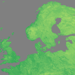
The NASA Suomi National Polar-Orbiting Partnership (Suomi NPP) Visible Infrared Imaging Radiometer Suite (VIIRS) Land Surface Temperature and Emissivity (LST&E) Day Version 1 product (VNP21A1D) is compiled daily from daytime Level 2 Gridded (L2G) intermediate products.
The L2G process maps the daily VNP21 swath granules onto a sinusoidal MODIS grid and stores all observations overlapping a gridded cell for a given day. The VNP21A1 algorithm sorts through all these observations for each cell and estimates the final LST value as an average from all cloud-free observations that have good LST accuracies. Only observations having observation coverage more than a certain threshold (15%) are considered for this averaging.
Documentation:
Bands
Bands
Pixel size: 1000 meters (all bands)
LST_1KM
Daily 1 km Land Surface Temperature.
QC
Daily Quality control for LST and emissivity
Emis_14
Daily M14 emissivity
Emis_15
Daily M15 emissivity
Emis_16
Daily M16 emissivity
View_Angle
View zenith angle of LST
View_Time
Time of LST observation
Terms of Use
Terms of Use
LP DAAC NASA data are freely accessible; however, when an author publishes these data or works based on the data, it is requested that the author cite the datasets within the text of the publication and include a reference to them in the reference list.
Citations
-
Please visit LP DAAC 'Citing Our Data' page for information on citing LP DAAC datasets.
DOIs
Explore with Earth Engine
Code Editor (JavaScript)
 var

 dataset

 =

 ee
 .
 ImageCollection
 (
 'NASA/VIIRS/002/VNP21A1D'
 )

 .
 filter
 (
 ee
 .
 Filter
 .
 date
 (
 '2022-11-01'
 ,

 '2022-12-01'
 ));
 var

 visualization

 =

 {

 bands
 :

 [
 'LST_1KM'
 ],

 min
 :

 [
 150
 ],

 max
 :

 [
 300
 ],

 palette
 :

 [

 'a50026'
 ,

 'd73027'
 ,

 'f46d43'
 ,

 'fdae61'
 ,

 'fee08b'
 ,

 'ffffbf'
 ,

 'd9ef8b'
 ,

 'a6d96a'
 ,

 '66bd63'
 ,

 '1a9850'
 ,

 '006837'
 ,

 ]
 };
 Map
 .
 setCenter
 (
 41.2
 ,

 38.84
 ,

 3
 );
 Map
 .
 addLayer
 (
 dataset
 ,

 visualization
 ,

 'LST'
 );