
Page Summary
-
The NOAA/VIIRS/001/VNP46A1 dataset provides global daily measurements of nocturnal visible and near-infrared light from 2012 to 2025.
-
This dataset, provided by NASA LAADS DAAC, offers a daily top-of-atmosphere, at-sensor nighttime radiance product with 26 Science Data Sets including radiance, angles, and quality flags.
-
The VIIRS Day-Night Band sensor is ultra-sensitive in lowlight conditions, providing improved sensor resolution and calibration compared to previous nighttime light products.
-
The dataset includes various bands and quality flags, such as at-sensor DNB radiance, lunar and solar angles, cloud mask flags, and brightness temperatures for multiple VIIRS bands.
-
Access to this dataset for research, education, and non-profit use is available through the Earth Engine platform, with provided documentation and code examples.
- Dataset Availability
- 2012-01-19T00:00:00Z–2025-01-02T00:00:00Z
- Dataset Producer
- NASA LAADS DAAC
- Cadence
- 1 Day
- Tags
Description
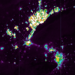
The Suomi National Polar-orbiting Partnership (SNPP) Visible Infrared Imaging Radiometer Suite (VIIRS) supports a Day-Night Band (DNB) sensor that provides global daily measurements of nocturnal visible and near-infrared (NIR) light that are suitable for Earth system science and applications. The VIIRS DNB's ultra-sensitivity in lowlight conditions enables us to generate a new set of science-quality nighttime products that manifest substantial improvements in sensor resolution and calibration when compared to the previous era of Defense Meteorological Satellite Program/Operational Linescan System's (DMSP/OLS) nighttime lights image products.
VNP46A1 is a daily, top-of-atmosphere, at-sensor nighttime radiance product called VIIRS/NPP Daily Gridded Day Night Band 15 arc-second Linear Lat Lon Grid Night. The product contains 26 Science Data Sets (SDS) that include sensor radiance, zenith and azimuth angles (at-sensor, solar, and lunar), cloud-mask flags, time, shortwave IR radiance, brightness temperatures, VIIRS quality flags, moon phase angle, and moon illumination fraction. It also provides Quality Flag (QF) information specific to the cloud-mask, VIIRS moderate-resolution bands M10, M11, M12, M13, M15, M16, and DNB.
Documentation:
Bands
Bands
Pixel size: 500 meters (all bands)
BrightnessTemperature_M12
Brightness temperature of band M12
BrightnessTemperature_M13
Brightness temperature of band M13
BrightnessTemperature_M15
Brightness temperature of band M15
BrightnessTemperature_M16
Brightness temperature of band M16
DNB_At_Sensor_Radiance_500m
At-sensor DNB radiance
Glint_Angle
Moon glint angle
Granule
Number of selected Granule
Lunar_Zenith
Lunar zenith angle
Lunar_Azimuth
Lunar azimuth angle
Moon_Illumination_Fraction
Moon illumination fraction
Moon_Phase_Angle
Moon phase angle
QF_Cloud_Mask
Quality flag for cloud mask
QF_DNB
DNB quality flag
QF_VIIRS_M10
Quality flag of band M10
QF_VIIRS_M11
Quality flag of band M11
QF_VIIRS_M12
Quality flag of band M12
QF_VIIRS_M13
Quality flag of band M13
QF_VIIRS_M15
Quality flag of band M15
QF_VIIRS_M16
Quality flag of band M16
Radiance_M10
Radiance in band M10
Radiance_M11
Radiance in band M11
Sensor_Azimuth
Sensor azimuth angle
Sensor_Zenith
Sensor zenith angle
Solar_Azimuth
Solar azimuth angle
Solar_Zenith
Solar zenith angle
UTC_Time
UTC time
QF_DNB Class Table
| Value | Color | Description |
|---|---|---|
|
1
|
None | Substitute_Cal |
|
2
|
None | Out_of_Range |
|
4
|
None | Saturation |
|
8
|
None | Temp_not_Nominal |
|
16
|
None | Stray_light |
|
256
|
None | Bowtie_Deleted |
|
512
|
None | Missing_EV |
|
1024
|
None | Cal_Fail |
|
2048
|
None | Dead_Detector |
QF_VIIRS_M10 Class Table
| Value | Color | Description |
|---|---|---|
|
1
|
None | Substitute_Cal |
|
2
|
None | Out_of_Range |
|
4
|
None | Saturation |
|
8
|
None | Temp_not_Nominal |
|
256
|
None | Bowtie_Deleted |
|
512
|
None | Missing_EV |
|
1024
|
None | Cal_Fail |
|
2048
|
None | Dead_Detector |
QF_VIIRS_M11 Class Table
| Value | Color | Description |
|---|---|---|
|
1
|
None | Substitute_Cal |
|
2
|
None | Out_of_Range |
|
4
|
None | Saturation |
|
8
|
None | Temp_not_Nominal |
|
256
|
None | Bowtie_Deleted |
|
512
|
None | Missing_EV |
|
1024
|
None | Cal_Fail |
|
2048
|
None | Dead_Detector |
QF_VIIRS_M12 Class Table
| Value | Color | Description |
|---|---|---|
|
1
|
None | Substitute_Cal |
|
2
|
None | Out_of_Range |
|
4
|
None | Saturation |
|
8
|
None | Temp_not_Nominal |
|
256
|
None | Bowtie_Deleted |
|
512
|
None | Missing_EV |
|
1024
|
None | Cal_Fail |
|
2048
|
None | Dead_Detector |
QF_VIIRS_M13 Class Table
| Value | Color | Description |
|---|---|---|
|
1
|
None | Substitute_Cal |
|
2
|
None | Out_of_Range |
|
4
|
None | Saturation |
|
8
|
None | Temp_not_Nominal |
|
256
|
None | Bowtie_Deleted |
|
512
|
None | Missing_EV |
|
1024
|
None | Cal_Fail |
|
2048
|
None | Dead_Detector |
QF_VIIRS_M15 Class Table
| Value | Color | Description |
|---|---|---|
|
1
|
None | Substitute_Cal |
|
2
|
None | Out_of_Range |
|
4
|
None | Saturation |
|
8
|
None | Temp_not_Nominal |
|
256
|
None | Bowtie_Deleted |
|
512
|
None | Missing_EV |
|
1024
|
None | Cal_Fail |
|
2048
|
None | Dead_Detector |
QF_VIIRS_M16 Class Table
| Value | Color | Description |
|---|---|---|
|
1
|
None | Substitute_Cal |
|
2
|
None | Out_of_Range |
|
4
|
None | Saturation |
|
8
|
None | Temp_not_Nominal |
|
256
|
None | Bowtie_Deleted |
|
512
|
None | Missing_EV |
|
1024
|
None | Cal_Fail |
|
2048
|
None | Dead_Detector |
Terms of Use
Terms of Use
LP DAAC NASA data are freely accessible; however, when an author publishes these data or works based on the data, it is requested that the author cite the datasets within the text of the publication and include a reference to them in the reference list.
Citations
-
Please visit LP DAAC 'Citing Our Data' page
DOIs
Explore with Earth Engine
Code Editor (JavaScript)
 var

 dataset

 =

 ee
 .
 ImageCollection
 (
 'NOAA/VIIRS/001/VNP46A1'
 ).
 filter
 (

 ee
 .
 Filter
 .
 date
 (
 '2013-01-01'
 ,

 '2013-07-01'
 ));
 // At-sensor Day/night Band radiance (DNB).
 var

 dnb

 =

 dataset
 .
 select
 (
 'DNB_At_Sensor_Radiance_500m'
 );
 var

 dnbVis

 =

 {

 min
 :

 0
 ,

 max
 :

 50
 ,

 palette
 :

 [
 'black'
 ,

 'purple'
 ,

 'cyan'
 ,

 'green'
 ,

 'yellow'
 ,

 'red'
 ,

 'white'
 ],
 };
 Map
 .
 setCenter
 (
 -
 79.4
 ,

 43.1
 ,

 8
 );
 Map
 .
 addLayer
 (
 dnb
 ,

 dnbVis
 ,

 'Day-Night Band (DNB) at sensor radiance 500m'
 );