
Page Summary
-
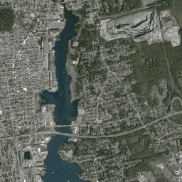
This dataset contains pansharpened RGB images from Planet Labs Inc.SkySat satellites collected from 2014 to 2016.
-
The images have a resolution of approximately 0.8m per pixel and include R, G, and B bands.
-
The data was collected for the "Skybox for Good Beta" program, crisis response events, and other projects.
-
This dataset is available under the Creative Commons by Attribution license (CC-BY-4.0).
- Dataset Availability
- 2014-07-03T00:00:00Z–2016-12-24T00:00:00Z
- Dataset Producer
- Planet Labs Inc.
- Tags
Description
This data from Planet labs Inc. SkySat satellites was collected for the experimental "Skybox for Good Beta" program in 2015, as well as for various crisis response events and a few other projects. The data is available in both a 5-band Multispectral/Pan collection, and a Pansharpened RGB collection.
Each image's asset ID contains the acquisition date and time, for example, image s01_20150304T080608Z was acquired on March 4, 2015 at 08:06 Zulu (UTC). For more information, please see the Planet Imagery Product Specifications and visit the Planet Imagery and Archive site.
This RGB collection contains images with three pansharpened, 8-bit bands. The resolution is approximately 0.8m per pixel (closer to 1m for off-nadir images).
Bands
Bands
Pixel size: 0.8 meters (all bands)
| Name | Min | Max | Pixel Size | Wavelength | Description |
|---|---|---|---|---|---|
R
|
1* | 255* | 0.8 meters | 605-695nm | Red |
G
|
1* | 255* | 0.8 meters | 515-595nm | Green |
B
|
1* | 255* | 0.8 meters | 450-515nm | Blue |
Image Properties
Image Properties
| Name | Type | Description |
|---|---|---|
|
catalogID
|
STRING | Unique catalog ID corresponding to a single collection event; same across all three detectors. |
|
collectionEndTime
|
STRING | ISO 8601 collection end time (UTC). |
|
collectionStartTime
|
STRING | ISO 8601 collection start time (UTC). |
|
collectionType
|
STRING | 'Strip', 'Point', 'Area', or 'Path'. |
|
productType
|
STRING | Product type identifying the product level ('Orthorectified Imagery'). |
|
productionID
|
STRING | ID of this version of this product, generated by Singer/TileMill. |
|
productionSystemVersion
|
STRING | N/A |
|
resamplingMethod
|
STRING | The method used for interpolated pixel values. |
|
satelliteAzimuthAngleMax
|
DOUBLE | Maximum satellite azimuth angle over the collection (degrees). |
|
satelliteAzimuthAngleMean
|
DOUBLE | Mean satellite azimuth angle over the collection (degrees). |
|
satelliteAzimuthAngleMin
|
DOUBLE | Minimum satellite azimuth angle over the collection (degrees). |
|
satelliteElevationAngleMax
|
DOUBLE | Maximum satellite elevation angle over the collection (degrees). |
|
satelliteElevationAngleMean
|
DOUBLE | Mean satellite elevation angle over the collection (degrees). |
|
satelliteElevationAngleMin
|
DOUBLE | Minimum satellite elevation angle over the collection (degrees). |
|
satelliteName
|
STRING | Unique name identifying the spacecraft. |
|
snaptoAlignmentConfidence
|
DOUBLE | N/A |
|
snaptoReferenceAssets
|
STRING | N/A |
|
solarAzimuthAngle
|
DOUBLE | Solar azimuth angle at the time of collection. |
|
solarElevationAngle
|
DOUBLE | Solar elevation angle at the time of collection. |
|
terrainBlendEpoch
|
DOUBLE | N/A |
Terms of Use
Terms of Use
This dataset is made available publicly under the Creative Commons by Attribution license(CC-BY-4.0).
Citations
-
© <year> Planet Labs Inc.
Explore with Earth Engine
Code Editor (JavaScript)
 var

 dataset

 =

 ee
 .
 ImageCollection
 (
 'SKYSAT/GEN-A/PUBLIC/ORTHO/RGB'
 );
 var

 rgb

 =

 dataset
 .
 select
 ([
 'R'
 ,

 'G'
 ,

 'B'
 ]);
 var

 rgbVis

 =

 {

 min
 :

 11.0
 ,

 max
 :

 190.0
 ,
 };
 Map
 .
 setCenter
 (
 -
 70.892
 ,

 41.6555
 ,

 15
 );
 Map
 .
 addLayer
 (
 rgb
 ,

 rgbVis
 ,

 'RGB'
 );