
Page Summary
-
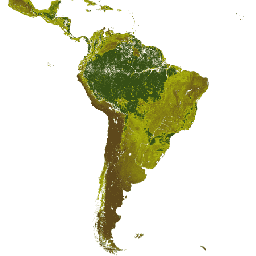
GCOM-C/SGLI L3 Leaf Area Index product measures the sum of one-sided green leaf area per unit ground area and has multiple versions available.
-
The MODIS Leaf Area Index/FPAR products (MCD15A3H, MOD15A2H, MYD15A2H) are composite datasets at 500m resolution derived from Terra and Aqua sensors.
-
The NOAA CDR AVHRR LAI FAPAR dataset characterizes canopy and photosynthetic activity using values derived from AVHRR Surface Reflectance.
-
The NOAA CDR VIIRS LAI FAPAR dataset combines Leaf Area Index and Fraction of Absorbed Photosynthetically Active Radiation to evaluate vegetation stress and aid in agricultural forecasting and resource management.
-
GCOM-C/SGLI L3 Leaf Area Index (V1)
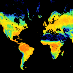
This product is the sum of the one-sided green leaf area per unit ground area. A newer version JAXA/GCOM-C/L3/LAND/LAI/V3 is also available for this dataset which uses this algorithm for processing. GCOM-C conducts long-term and continuous global observation and data collection to elucidate the mechanism … g-portal gcom gcom-c jaxa lai land -
GCOM-C/SGLI L3 Leaf Area Index (V2)

This product is the sum of the one-sided green leaf area per unit ground area. For data after 2021-11-28, see the V3 dataset. GCOM-C conducts long-term and continuous global observation and data collection to elucidate the mechanism behind fluctuations in radiation budget and carbon cycle … g-portal gcom gcom-c jaxa lai land -
GCOM-C/SGLI L3 Leaf Area Index (V3)

This product is the sum of the one-sided green leaf area per unit ground area. This is an ongoing dataset with a latency of 3-4 days. GCOM-C conducts long-term and continuous global observation and data collection to elucidate the mechanism behind fluctuations in radiation budget … g-portal gcom gcom-c jaxa lai land -
MCD15A3H.061 MODIS Leaf Area Index/FPAR 4-Day Global 500m
The MCD15A3H Version 6.1 Moderate Resolution Imaging Spectroradiometer (MODIS) Level 4, Combined Fraction of Photosynthetically Active Radiation (FPAR), and Leaf Area Index (LAI) product is a 4-day composite data set with 500 meter pixel size. The algorithm chooses the best pixel available from all the … fpar global lai modis nasa plant-productivity -
MOD15A2H.061: Terra Leaf Area Index/FPAR 8-Day Global 500m
The MOD15A2H V6.1 MODIS combined Leaf Area Index (LAI) and Fraction of Photosynthetically Active Radiation (FPAR) product is an 8-day composite dataset at 500m resolution. The algorithm chooses the "best" pixel available from all the acquisitions of the Terra sensor from within the 8-day period. … 8-day fpar global lai modis nasa -
MYD15A2H.061: Aqua Leaf Area Index/FPAR 8-Day Global 500m
The MYD15A2H V6.1 MODIS combined Leaf Area Index (LAI) and Fraction of Photosynthetically Active Radiation (FPAR) product is an 8-day composite dataset at 500m resolution. The algorithm chooses the "best" pixel available from all the acquisitions of the Aqua sensor from within the 8-day period. … 8-day aqua fpar global lai modis -
NOAA CDR AVHRR LAI FAPAR: Leaf Area Index and Fraction of Absorbed Photosynthetically Active Radiation, Version 5
The NOAA Climate Data Record (CDR) of AVHRR Leaf Area Index (LAI) and Fraction of Absorbed Photosynthetically Active Radiation (FAPAR) dataset contains derived values that characterize the canopy and photosynthetic activity of plants. This dataset is derived from the NOAA AVHRR Surface Reflectance product and … avhrr cdr daily fapar lai land -
NOAA CDR VIIRS LAI FAPAR: Leaf Area Index and Fraction of Absorbed Photosynthetically Active Radiation, Version 1

This Climate Data Record (CDR) combines datasets for Leaf Area Index (LAI) and Fraction of Absorbed Photosynthetically Active Radiation (FAPAR), two biophysical variables that can be used to evaluate vegetation stress, forecast agricultural yields, and other modeling and resource management applications. LAI tracks the one-sided … cdr daily fapar lai land noaa