Page Summary
-
Learn how to hide map features like POIs and transit icons using JSON styling.
-
Apply custom styles by passing a JSON object to your map using
GoogleMap.setMapStyle(). -
Define styles using JSON either as a raw resource or a string resource in your Android project.
-
Understand the concepts of selectors (featureType, elementType) and stylers to control map elements' appearance.
-
Explore the Maps Platform Styling Wizard for an easy way to create custom map styles.
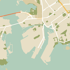
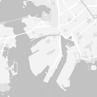
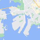
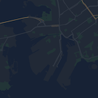
As well as changing the style of features on the map, you can also hide them entirely. This example shows you how to hide business points of interest (POIs) and public transit icons on your map.
Styling works only on the normal
map type. Styling does not affect indoor maps
, so using styling to hide features does not prevent
indoor floor plans from appearing on the map.
Pass a JSON style object to your map
To style your map, call GoogleMap.setMapStyle()
passing a MapStyleOptions
object that contains your style
declarations in JSON format. You can load the JSON from a raw resource or a
string, as shown in the following examples:
Raw resource
The following code sample assumes your project contains a raw resource named style_json
:
 //
 Copyright
 2020
 Google
 LLC
 //
 //
 Licensed
 under
 the
 Apache
 License
 ,
 Version
 2.0
 (
 the
 "License"
 );
 //
 you
 may
 not
 use
 this
 file
 except
 in
 compliance
 with
 the
 License
 .
 //
 You
 may
 obtain
 a
 copy
 of
 the
 License
 at
 //
 //
 http
 :
 //
 www
 .
 apache
 .
 org
 /
 licenses
 /
 LICENSE
 -
 2.0
 //
 //
 Unless
 required
 by
 applicable
 law
 or
 agreed
 to
 in
 writing
 ,
 software
 //
 distributed
 under
 the
 License
 is
 distributed
 on
 an
 "AS IS"
 BASIS
 ,
 //
 WITHOUT
 WARRANTIES
 OR
 CONDITIONS
 OF
 ANY
 KIND
 ,
 either
 express
 or
 implied
 .
 //
 See
 the
 License
 for
 the
 specific
 language
 governing
 permissions
 and
 //
 limitations
 under
 the
 License
 .
 package
 com
 .
 example
 .
 styledmap
 ;
 import

 android.content.res.Resources
 ;
 import

 android.os.Bundle
 ;
 import

 android.util.Log
 ;
 import

 androidx.appcompat.app.AppCompatActivity
 ;
 import

 com.google.android.gms.maps.CameraUpdateFactory
 ;
 import

 com.google.android.gms.maps.GoogleMap
 ;
 import

 com.google.android.gms.maps.OnMapReadyCallback
 ;
 import

 com.google.android.gms.maps.SupportMapFragment
 ;
 import

 com.google.android.gms.maps.model.LatLng
 ;
 import

 com.google.android.gms.maps.model.MapStyleOptions
 ;
 /**
 *
 A
 styled
 map
 using
 JSON
 styles
 from

 a
 raw
 resource
 .
 */
 public
 class

 MapsActivityRaw
 extends
 AppCompatActivity
 implements
 OnMapReadyCallback
 {
 private
 static
 final
 String
 TAG
 =
 MapsActivityRaw
 .
 class
 .
 getSimpleName
 ();
 @Override
 protected
 void
 onCreate
 (
 Bundle
 savedInstanceState
 )
 {
 super
 .
 onCreate
 (
 savedInstanceState
 );
 //
 Retrieve
 the
 content
 view
 that
 renders
 the
 map
 .
 setContentView
 (
 R
 .
 layout
 .
 activity_maps_raw
 );
 //
 Get
 the
 SupportMapFragment
 and
 register
 for
 the
 callback
 //
 when
 the
 map
 is
 ready
 for
 use
 .
 SupportMapFragment
 mapFragment
 =
 (
 SupportMapFragment
 )
 getSupportFragmentManager
 ()
 .
 findFragmentById
 (
 R
 .
 id
 .
 map
 );
 mapFragment
 .
 getMapAsync
 (
 this
 );
 }
 /**
 *
 Manipulates
 the
 map
 when
 it
 's available.
 *
 The
 API
 invokes
 this
 callback
 when
 the
 map
 is
 ready
 for
 use
 .
 */
 @Override
 public
 void
 onMapReady
 (
 GoogleMap
 googleMap
 )
 {
 try
 {
 //
 Customise
 the
 styling
 of
 the
 base
 map
 using
 a
 JSON
 object
 defined
 //
 in
 a
 raw
 resource
 file
 .
 boolean
 success
 =
 googleMap
 .
 setMapStyle
 (
 MapStyleOptions
 .
 loadRawResourceStyle
 (
 this
 ,
 R
 .
 raw
 .
 style_json
 ));
 if
 (
 !
 success
 )
 {
 Log
 .
 e
 (
 TAG
 ,
 "Style parsing failed."
 );
 }
 }
 catch
 (
 Resources
 .
 NotFoundException
 e
 )
 {
 Log
 .
 e
 (
 TAG
 ,
 "Can't find style. Error: "
 ,
 e
 );
 }
 //
 Position
 the
 map
 's camera near Sydney, Australia.
 googleMap
 .
 moveCamera
 (
 CameraUpdateFactory
 .
 newLatLng
 (
 new
 LatLng
 (
 -
 34
 ,
 151
 )));
 }
 }
Define a raw resource in /res/raw/style_json.json
, containing
the following JSON style declaration to hide business points of interest
(POIs):
The following style declaration hides business points of interest (POIs) and public transit icons:
The layout ( activity_maps.xml
) looks like this:
String resource
The following code sample assumes your project contains a string resource
named style_json
:
 package
 com
 .
 example
 .
 styledmap
 ;
 import

 android.os.Bundle
 ;
 import

 android.support.v7.app.AppCompatActivity
 ;
 import

 android.util.Log
 ;
 import

 com.google.android.gms.maps.CameraUpdateFactory
 ;
 import

 com.google.android.gms.maps.GoogleMap
 ;
 import

 com.google.android.gms.maps.OnMapReadyCallback
 ;
 import

 com.google.android.gms.maps.SupportMapFragment
 ;
 import

 com.google.android.gms.maps.model.LatLng
 ;
 import

 com.google.android.gms.maps.model.MapStyleOptions
 ;
 /**
 *
 A
 styled
 map
 using
 JSON
 styles
 from

 a
 string
 resource
 .
 */
 public
 class

 MapsActivityString
 extends
 AppCompatActivity
 implements
 OnMapReadyCallback
 {
 private
 static
 final
 String
 TAG
 =
 MapsActivityString
 .
 class
 .
 getSimpleName
 ();
 @Override
 protected
 void
 onCreate
 (
 Bundle
 savedInstanceState
 )
 {
 super
 .
 onCreate
 (
 savedInstanceState
 );
 //
 Retrieve
 the
 content
 view
 that
 renders
 the
 map
 .
 setContentView
 (
 R
 .
 layout
 .
 activity_maps_string
 );
 //
 Get
 the
 SupportMapFragment
 and
 register
 for
 the
 callback
 //
 when
 the
 map
 is
 ready
 for
 use
 .
 SupportMapFragment
 mapFragment
 =
 (
 SupportMapFragment
 )
 getSupportFragmentManager
 ()
 .
 findFragmentById
 (
 R
 .
 id
 .
 map
 );
 mapFragment
 .
 getMapAsync
 (
 this
 );
 }
 /**
 *
 Manipulates
 the
 map
 when
 it
 's available.
 *
 The
 API
 invokes
 this
 callback
 when
 the
 map
 is
 ready
 for
 use
 .
 */
 @Override
 public
 void
 onMapReady
 (
 GoogleMap
 googleMap
 )
 {
 //
 Customise
 the
 styling
 of
 the
 base
 map
 using
 a
 JSON
 object
 defined
 //
 in
 a
 string
 resource
 file
 .
 First
 create
 a
 MapStyleOptions
 object
 //
 from

 the
 JSON
 styles
 string
 ,
 then
 pass
 this
 to
 the
 setMapStyle
 //
 method
 of
 the
 GoogleMap
 object
 .
 boolean
 success
 =
 googleMap
 .
 setMapStyle
 (
 new
 MapStyleOptions
 (
 getResources
 ()
 .
 getString
 (
 R
 .
 string
 .
 style_json
 )));
 if
 (
 !
 success
 )
 {
 Log
 .
 e
 (
 TAG
 ,
 "Style parsing failed."
 );
 }
 //
 Position
 the
 map
 's camera near Sydney, Australia.
 googleMap
 .
 moveCamera
 (
 CameraUpdateFactory
 .
 newLatLng
 (
 new
 LatLng
 (
 -
 34
 ,
 151
 )));
 }
 }
Define a string resource in /res/values/style_strings.xml
,
containing the following JSON style declaration to hide business points of
interest (POIs). In this file you need to use a backslash to escape the
quotation marks:
The following style declaration hides business points of interest (POIs) and public transit icons:
The layout ( activity_maps.xml
) looks like this:
JSON style declarations
Styled maps use two concepts to apply colors and other style changes to a map:
- Selectorsspecify the geographic components that you can
style on the map. These include roads, parks, bodies of water, and
more, as well as their labels. The selectors include features
and elements
, specified as
featureTypeandelementTypeproperties. - Stylersare color and visibility properties that you can apply to map elements. They define the displayed color through a combination of hue, color, and lightness/gamma values.
See the style reference for a detailed description of the JSON styling options.
Maps Platform Styling Wizard