Send feedback
Add a polyline to a map Stay organized with collections
Save and categorize content based on your preferences.
This product or feature is Experimental (pre-GA).
Pre-GA products and features might have limited support, and changes to pre-GA products and
features might not be compatible with other pre-GA versions. Pre-GA Offerings are covered by
the Google
Maps Platform Service Specific Terms
. For more information, see the launch stage descriptions
.
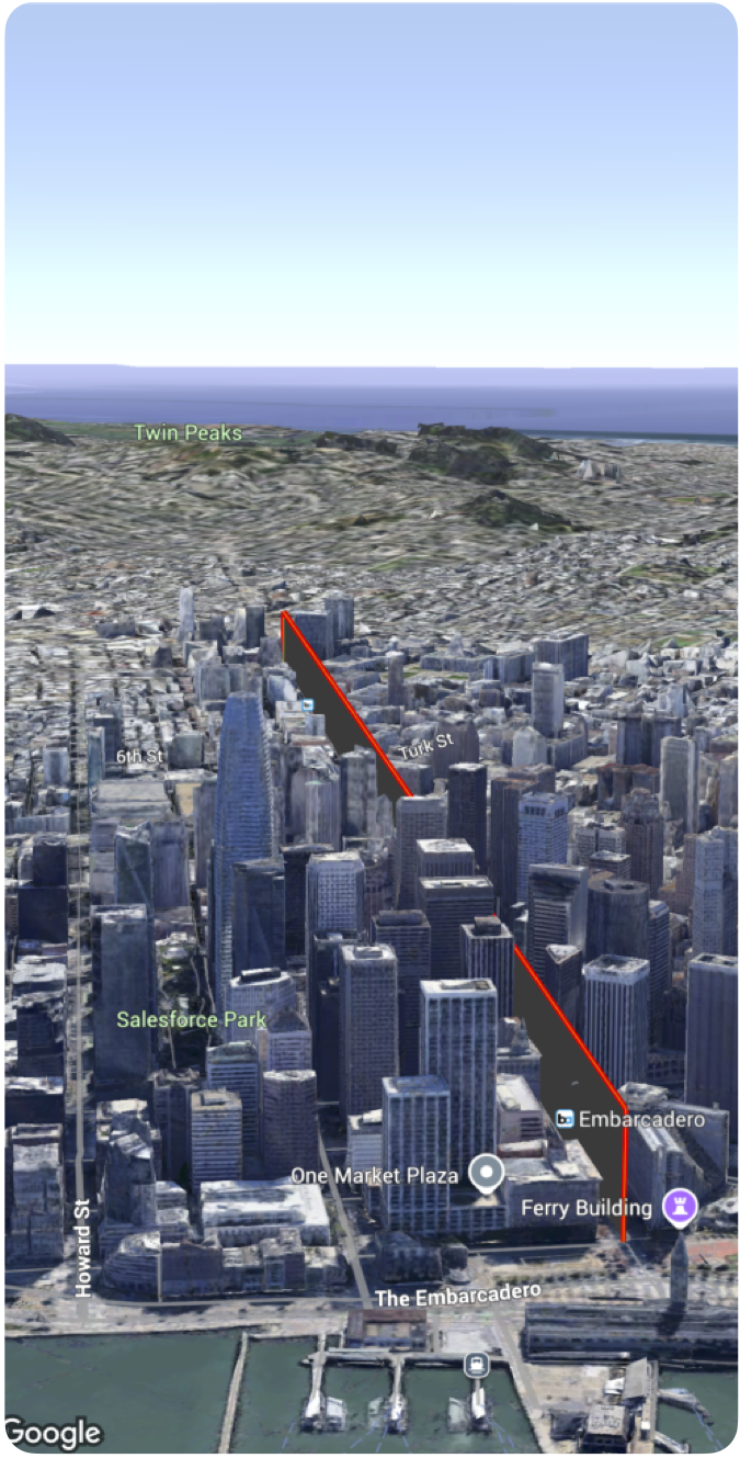
You can add a polyline to a 3D map.
The following code sample demonstrates how to use the Polyline
struct to add a polyline and position it on the map.
 Polyline
 (
 path
 :

 [

 .
 init
 (
 latitude
 :

 37.7749
 ,

 longitude
 :

 -
 122.4194
 ,

 altitude
 :

 100
 ),

 .
 init
 (
 latitude
 :

 37.7750
 ,

 longitude
 :

 -
 122.4193
 ,

 altitude
 :

 100
 ),

 .
 init
 (
 latitude
 :

 37.7751
 ,

 longitude
 :

 -
 122.4192
 ,

 altitude
 :

 100
 )

 ]

 .
 stroke
 (.
 init
 (
 strokeColor
 :

 .
 red
 ,

 strokeWidth
 :

 5.0
 ,

 outerColor
 :

 .
 blue
 ,

 outerWidth
 :

 0.2
 ))

 .
 contour
 (.
 init
 (
 isGeodesic
 :

 false
 ,

 extruded
 :

 true
 ,

 drawOccludedSegments
 :

 true
 )))
Send feedback
Except as otherwise noted, the content of this page is licensed under the Creative Commons Attribution 4.0 License
, and code samples are licensed under the Apache 2.0 License
. For details, see the Google Developers Site Policies
. Java is a registered trademark of Oracle and/or its affiliates.
Last updated 2026-06-11 UTC.
Need to tell us more?
[[["Easy to understand","easyToUnderstand","thumb-up"],["Solved my problem","solvedMyProblem","thumb-up"],["Other","otherUp","thumb-up"]],[["Missing the information I need","missingTheInformationINeed","thumb-down"],["Too complicated / too many steps","tooComplicatedTooManySteps","thumb-down"],["Out of date","outOfDate","thumb-down"],["Samples / code issue","samplesCodeIssue","thumb-down"],["Other","otherDown","thumb-down"]],["Last updated 2026-06-11 UTC."],[],[]]