テーマ: 海外生活(7778)
カテゴリ: 世界文化遺産
ピレネーを越える・・フランスからピレネー越えでサンチャゴ・デ・コンポステラ(Santiago de Compostela)→Finisterreまでの1200kmを歩いた。この絵日記編を9/27から掲載しています。その14-フランス→スペイン国境越え
旅の写真も2,3枚掲載致しています文章の肉付けとしてお読みください。
絵は最上部に掲載しています。
14..2010/08/15(Sun) Saint Jean Pied de Port サン・ジャン・ピエ・ド・ポール→ Roncesvalles ロンセスバージェス(25km)
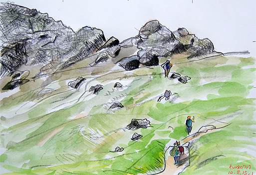
picture1:Route Napoleon , Alt 1409m Pic de Leizar Atheka,France
ピレネー越え、最高地点近く。
この地点までは、山の頂まで牧場が続いた。
羊や牛が我々を見下ろすという状況が続いていた。
camino道を通らず、直線ルートをよじ登る巡礼者達。
I go over Pyrenees.
Near the Summit level .
To this spot, a ranch spread out to the top of the mountain.
The situation that a sheep and a cow looked down at us continued.
The pilgrims whom didn't go along the camino way, and climb up the straight line route.
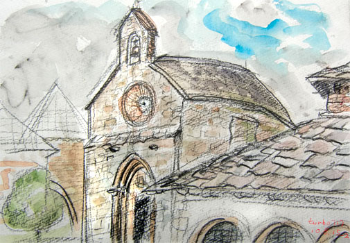
picture2:Roncesvalles ,
Iglesia de Santiago o de los Peregrinos, siglo XIII Spain
切り立った山の麓。
Ibaneta(イバニェタ峠 1057m)を越えて麓に辿りつく。
修道院と聖母ロンセスバージェス教会
The foot of the sheer mountain.
I arrive at the foot ahead of Ibaneta(1,057m). Monastery and Holy Mother Roncesvalles church" la iglesia de Santiago"
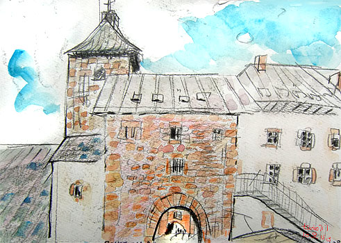
picture3:Colegiata de Roncesvalles, Spain
ロンセスバージェス修道院
スペイン側にある初めての建物。トンネルをくぐって修道院の道を進む。
アルベルゲ受付事務所は次のトンネルの右側にある。
Roncesvalles Monastery
The first building which there is in the Spanish side.
Camino pass through the tunnel and go ahead through the way of the monastery.
There is the Albergue-receptionist office in the right side of the next tunnel
日記
いよいよフランスからスペイン国境越えの旅が始まった。Saint Jean Pied de Port サン・ジャン・ピエ・ド・ポールには13箇所もの宿泊施設がありここを起点として巡礼を始めるcaminoの便を図っている。
われわれはすでにノートルダム門をくぐり、ニーベ川を渡った南側の坂道の中間にあるGite d'Etapeに宿泊しているため、すこしばかり有利。
パン屋でパンを仕入れたり、今晩の夕食の材料などをリュックにつめていざ出発。あとで分ったことであるがRoncesvalles ロンセスバージェスにあるアルベルゲ(旅宿)は宿泊のみでレストランでの食事が必要。
結局食料品は買っておく必要がなかった。峠を越えた分すこし徒労に終わった感じがする。
ハンニバルが象を連れていった場所、ナポレオンの道(Route Napoleon)。
Col de Bentartea(ベンタルテア峠:1330m)近く)→Col de Lepoeder(レポエデール峠:1430m)までの稜線。
1250mもの高度差を息を切らしながら登る。ここ(picture1 参照)を越えるとほぼ平坦な峠道が続く。
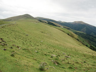
photo1: Pyrenees.France 2010.8.15 10:54
旅の写真も2,3枚掲載致しています文章の肉付けとしてお読みください。
絵は最上部に掲載しています。
14..2010/08/15(Sun) Saint Jean Pied de Port サン・ジャン・ピエ・ド・ポール→ Roncesvalles ロンセスバージェス(25km)

picture1:Route Napoleon , Alt 1409m Pic de Leizar Atheka,France
ピレネー越え、最高地点近く。
この地点までは、山の頂まで牧場が続いた。
羊や牛が我々を見下ろすという状況が続いていた。
camino道を通らず、直線ルートをよじ登る巡礼者達。
I go over Pyrenees.
Near the Summit level .
To this spot, a ranch spread out to the top of the mountain.
The situation that a sheep and a cow looked down at us continued.
The pilgrims whom didn't go along the camino way, and climb up the straight line route.

picture2:Roncesvalles ,
Iglesia de Santiago o de los Peregrinos, siglo XIII Spain
切り立った山の麓。
Ibaneta(イバニェタ峠 1057m)を越えて麓に辿りつく。
修道院と聖母ロンセスバージェス教会
The foot of the sheer mountain.
I arrive at the foot ahead of Ibaneta(1,057m). Monastery and Holy Mother Roncesvalles church" la iglesia de Santiago"

picture3:Colegiata de Roncesvalles, Spain
ロンセスバージェス修道院
スペイン側にある初めての建物。トンネルをくぐって修道院の道を進む。
アルベルゲ受付事務所は次のトンネルの右側にある。
Roncesvalles Monastery
The first building which there is in the Spanish side.
Camino pass through the tunnel and go ahead through the way of the monastery.
There is the Albergue-receptionist office in the right side of the next tunnel
日記
いよいよフランスからスペイン国境越えの旅が始まった。Saint Jean Pied de Port サン・ジャン・ピエ・ド・ポールには13箇所もの宿泊施設がありここを起点として巡礼を始めるcaminoの便を図っている。
われわれはすでにノートルダム門をくぐり、ニーベ川を渡った南側の坂道の中間にあるGite d'Etapeに宿泊しているため、すこしばかり有利。
パン屋でパンを仕入れたり、今晩の夕食の材料などをリュックにつめていざ出発。あとで分ったことであるがRoncesvalles ロンセスバージェスにあるアルベルゲ(旅宿)は宿泊のみでレストランでの食事が必要。
結局食料品は買っておく必要がなかった。峠を越えた分すこし徒労に終わった感じがする。
ハンニバルが象を連れていった場所、ナポレオンの道(Route Napoleon)。
Col de Bentartea(ベンタルテア峠:1330m)近く)→Col de Lepoeder(レポエデール峠:1430m)までの稜線。
1250mもの高度差を息を切らしながら登る。ここ(picture1 参照)を越えるとほぼ平坦な峠道が続く。

photo1: Pyrenees.France 2010.8.15 10:54
スペイン側に入ると樺の美しい森。
今後木を見ることが少なくなるのであればゆっくり進むべきであった。
スペイン国内は40度の焦土と化していたからだ。
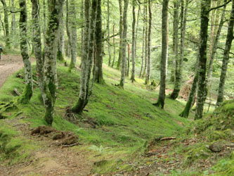
photo2:Pyrenees.birch-forest,Spain 2010.8.15 13:55
Albergueアルベルゲは4時openという。リュックを並べてキューを作るも、事務所のドアが開く前に並んだ順番で10人づつ調書に必要事項を書く。映画「サン・ジャックへの道(コリーヌ・セロ監督 ミュリエル・ロバン、アルチュス・バンゲルン、ジャン=ピエール・ダルッサン)」であった通りだ。
映画ではイスラム教徒がいたため宿泊を断られ一時間かけてホテルに辿りつくというストーリであった)、無事120人”収容”のアルベルゲに泊ることとなった。
なにせ体育館のように広い宿である。地階にシャワー室など。ベッドはスペイン国内に入ったとたん2段となり、寝袋の必要性に迫られる。フランス国内では毛布があり、夏場はまったく必要としなかったものである。
皆で7時半に予約したレストランに”巡礼メニュー”(9euro)なるものを食べに行く。サラダに「ます」の魚料理である。
こんがり焼かれていたので、骨から丸ごと食べたが、これが皆の注目となった。『猫ではあるまいし。ちゃんと骨は残すべきもの』という食文化の国からしてみれば奇異に映ったのであろうか。
アユの姿焼のような感じであったため丸ごと食べてカルシュームの摂取に努めたというのに。
9時にレストランを出る。目の前のアルベルゲの就寝時間は10時であり外はまだまだ明るいときている。ここからが面白い。皆それぞれお喋りに打ち興じるのである。
この旅では、夕食後の語らいが一番面白かった。
みんな山越えで疲れていたが、「日本式大笑い健康法」なるものを伝授することにした。
10人ほどを指導するのであるが、まず見本を見せる。あまりに面白いため、皆デジカメをvideoモードにして録画を始める。笑いすぎて、腸がおかしくなったが、大いに身体がリラックスした。
11時、就寝中に起こすものがいた。真っ暗になった部屋の一角がいやに明るい。
ロープに洗濯ものをぶら下げた者が犯人であった。なんとここは非常口であり、さらに消火器のヒンジにロープの端を結んでいたのだ。
非常のときにこれでは障害になるというのであった。
小生としては工夫した積りであったが・・・。浅はかであった!
ロープの創作物は写真に撮って後世に伝えるという。なんということか?
行程(スペイン国内)
14..2010/08/15(Sun) Saint Jean Pied de Port サン・ジャン・ピエ・ド・ポール→ Roncesvalles ロンセスバージェス(25km)
15..2010/8/16(Mon) Roncesvalles ロンセスバージェス→?Larrasoana ララソアーニャ(27km)
16..2010/8/17(Tue) ?Larrasoana ララソアー→?Pamplona パンプローナ→Uterga ウテルガ(32.9km)
17..2010/8/18(Wed) ?Uterga ウテルガ→Puente la Reina プエンテ・ラ・レイナ→?Lorca ロルカ(19.9km)
18..2919/8/19(Thr) ?Lorca ロルカ→?Los Arcos ロス・アルコス(30.8km)
19..2010/8/20(Fri) Los Arcos ロス・アルコス→?Viana ビアナ→?Logron ログローニョ(28km)
20..2010/8/21(Sat) ?Logron ログローニョ→?Najera ナヘラ(29km)
21..2010/8/22(Sun) Najera ナヘラ→?Santo Domingo de la Calzada サント・ドミンゴ・デ・ラ・カルサーダ(21km)
22..2010/8/23(Mon) ?Santo Domingo de la Calzada サント・ドミンゴ・デ・ラ・カルサーダ→Belorado ベラロード(22.9km)
23..2010/8/24(Tue) Belorado ベラロード→Ages アヘス(27,7km)
24..2010/8/25(Wed) Ages アヘス→Burgos ブルゴス(23.9km)
25,,2010/8/26(Thr) Burgos ブルゴス→Hontanas オンタナス(30.6km)
26..2010/8/27(Fri) Hontanas オンタナス→Fromista フロミスタ(34.4km)
27..2010/8/28(Sat) Fromista フロミスタ→Carrion de los Condes カリオン・デ・ロス・コンデス(19.3km)
28..2010/8/29(Sun) Carrion de los Condes カリオン・デ・ロス・コンデス→Terradillos de los Templarios テラディージョス・デ・ロス・テンプラリオス26.2km)
29,,2010/8/30(Mon) Terradillos de los Templarios テラディージョス・デ・ロス・テンプラリオス→Bercianos del Real Camino ベルアノス・デル・レアル・カミーノ(23/5km)
30..2010/8/31(Tue) Bercianos del Real Camino ベルアノス・デル・レアル・カミーノ→Mansilla de las Mulas マンシージャ・デ・ラス・ムラス(26.8km)
31,,2010/9/1(Wed) Mansilla de las Mulas マンシージャ・デ・ラス・ムラス→Leonレオン(20km)
続く
Picture1(sketch-direction 270°am11:14 Sketch point:Route Napoleon , Alt 1409m Pic de Leizar Atheka GPS 43.058786,-1.270469(°) (43°3'31.63" N,1°16'13.59" w ) ) )
Picture2(sketch-direction 30°pm5:27 Sketch point:Iglesia de Santiago Roncesvalles GPS 43.020511,-1.323678(°) (43°1'13.64" N,1°19'25.24" w ) ) )
Picture3(sketch-direction 180°pm6:38 Sketch point:Roncesvalles Monastery GPS 43.010272,-1.303050(°) (43°0'36.98" N,1°18'10.98" w ) ) )
移動距離の求め方・・前日と本日の移動距離や、picture1,2間の移動距離(垂直と水平)などは計算で求められます。
Distance Between Picture1 and Picture2(North-South)===3.14x6356.752km x(43.317433-43.316897)/180=59.45m south
Distance Between Picture1 and Picture2(East-West)===3.14x6378.137km x(-0.91773-(0.918083))/180=38.63m West
お気に入りの記事を「いいね!」で応援しよう
[世界文化遺産] カテゴリの最新記事
-
My Camino story,だれでもあーと Feb 12, 2017
-
麗しのカディス、Cádiz-2,2016.11.1-Memoi… Feb 4, 2017
-
Camino de Cádiz --Utrera-3,2016.10.27-M… Jan 30, 2017
【毎日開催】
15記事にいいね!で1ポイント
10秒滞在
いいね!
--
/
--
PR
X
Keyword Search
▼キーワード検索
小さくなったスプレ…
 New!
カーク船長4761さん
Can AI make life ea… 恵子421さん
尊徳生家を描く のん0319さん
遊人学舎 ゆうゆうきかくさん
介護ライフハック! ウルトラ・シンデレラさん
伝説のアラキ:)気… 気合・気愛:)さん
思い出の1枚 大地の花さん
アトリエ遊花 遊花8787さん
ぴっこらイタリア Ikukitoさん
うにゃ hiro4175さん
 New!
カーク船長4761さん
New!
カーク船長4761さんCan AI make life ea… 恵子421さん
尊徳生家を描く のん0319さん
遊人学舎 ゆうゆうきかくさん
介護ライフハック! ウルトラ・シンデレラさん
伝説のアラキ:)気… 気合・気愛:)さん
思い出の1枚 大地の花さん
アトリエ遊花 遊花8787さん
ぴっこらイタリア Ikukitoさん
うにゃ hiro4175さん
Comments
Freepage List
France_Sketch

Pont du Carrousel

Pont des Arts

Versailles

Chartre

Fontainebleau

Mont St-Michel

Amiens

Le Harbre

Chambord城

Chinon城

Provence_Avignon

Alps_Mont Blanc

Pont du Gard
Swiss__Sketch

Matterhorn

Boden gletshe

Unter Gabelhorn

Jungfrau_Eiger

Jungfraujoch

RothornKulm

Brienzer See

Pilatus Kulm

Zurich,Luzern
Deutch_Austria__Sketch

Schoenbrunn

Vienne_St.Stephane

Deutch_Rothenburg

Haideruberugu
Italy_Sketch

Roma Foro Romano

Roma St Angelo

Roma Caracalla

Napoli Pompei

Napoli Sorrent

Napoli Capri

Napoli Anacapri_

Sicily Monreale
England_Sketch

Regent's Park

Hampstead Heath

Windermere_Lake District

Keswick,Poem

Edinburgh,St,Giles

Scotland skech_1

Scotland skech_2

Scotland skech_3

Scotland skech_4

Scotland skech_5

Scotland London_skech_6

Scotland London_skech_7
Greece

Akropolis,Delphoi
USA

New York City Marathon-1

New York City Marathon-2

Washington

Grand Canyon-1

Grand Canyon-2

Los Angels-1

Los Angels-2
橋のある風景

Paris_Carrousel_bridge

Paris_Pont des Arts

Amian

Avignon

Heidelberg_カールトドール橋

Pont du Gard (Provence)

Segovia_Aqueductroローマ水道

Spain_Hospital de Orbigo

Spain_Portmarin

NewYork_Queensboro Bridge

Arlington Memorial Bri.

恵那峡大橋

飛泉橋

郡上市_吉田川_新橋

中央道・落合川橋

中津川_玉蔵橋

府中市_四谷橋

神田川_柳橋

隅田川_駒形橋

皇居_平川橋

阿寺渓谷_阿寺橋

木曽川_桃介橋

木曽川_巴ケ淵橋

堂島川_水晶橋

天神橋

馬飼大橋

桜橋

小倉橋

新小倉橋
中央アルプス

中央アルプス_木曽駒ケ岳_三ノ沢岳

宝剣岳(2931m)

木曽駒ケ岳

千畳敷_宝剣岳

宝剣岳(2931m)

檜尾岳(ひのきおだけ)

池の平カール(2660m)

東川岳(2671m)

百越山

空木岳

中央アルプス全景(晩秋)

仙涯嶺
南アルプス

塩湯温泉→三伏峠

三伏峠→荒川小屋

荒川小屋→二軒小屋

二軒小屋→下部温泉

鳳凰山眺望

易老渡→易老岳→茶臼山

茶臼小屋→上河内岳→聖平小屋

聖平小屋→聖岳→兎岳

兎岳→中盛丸山→百間洞山ノ家

百間洞山ノ家→赤石岳→兎岳

兎岳→薊(あざみ)畑分岐→易老渡

北岳

雪渓_北岳

北岳から鳳凰三山方向

広河原

雪の仙丈ケ岳
猫

猫_椿_梅

健太のこと

健太 っもう!

言うこと聞きなさい!

新聞バリケード

幼児返り?

ほんとうの 猫の気持ち ?

遊んで欲しい!

何か、重たい!

遊ぼ!

どきなさい!

カニ缶 いただき!

カニ缶の思い出

春眠

猫が詠んだ短歌

猫と5月歌舞伎

僕のこと好き?

猫の舌

川柳の巻

いただきます!

まん丸健太

猫が添い寝

台風と猫

稲妻と猫

水ください。

ピアノ止めニャイの?

今日の食事何?

1000回記念?

2008年 屋根の上の猫
植物

石垣島

バラ:ミスター・リンカーン

ミスター・リンカーン・・ほころび

チューリップ

桜-上大島キャンプ場

バラ-アンジェロゼ

青いバラ

Peace

ヒトツバタゴ

紅どうだん

ザマッカートニーローズ

栄光

ディスコダンサー

ベンジャミン ブリテンー

ラバグルート

タブリス

ラ マルセイエーズ

マチルデグッケス グリュンヘルツ

ホワイト ダイヤモンド

ヤエカシワバアジサイ

ハナショウブ

タイサンボク

大賀ハス

むくげ

タカネビランジ

ほおずき

紫式部

シラタマホシクサ

桜-紅葉

柿ー紅葉

冬薔薇_ピース

エリカ(ヒース)
温泉

延命の湯

勝沼町休息

満願成就の湯

ほったらかし温泉

猿ヶ京温泉(1)

猿ヶ京温泉(2)

ローソク温泉

冬のほったらかし温泉

中部国際空港
静物

Coffee cup

エミール・ガレ展

トンボ玉

招き猫

マトリョーシカ

コンパス
愛地球博_Expo2005

踊るサチュロス像

ギニア共和国

オランダ館

サツキとメイの家
町並み

酒蔵

麻布十番町

浅草寺

雷門
音楽

夏の第九

ハンドベル コンサート

新しい第九

ミシュクのピアノ

コントラバス物語

府中の森芸術劇場

Mozart250回目誕生日

ショパン国際ピアノコンクール

Violaとすみれ

「熱狂の日」音楽祭2006
紅葉の景色

香嵐渓_飯森山

香嵐渓_香積寺(こうじゃくじ)

ワシントン-アーリントン墓地

明治神宮外苑の銀杏並木

神宮外苑の銀杏並木(その2)

外苑の銀杏並木(その3)

イチョウの葉
御嶽山、恵那山

御嶽山夕暮れ_

御嶽山遠望(冬)

馬籠から恵那山(早春)

松田からの恵那山(早春)

茶畑からの恵那山(5月)

国道361号線からの御嶽山(6月)

早秋の恵那山(9月初旬)

冬の御嶽山
月

鎮魂

中秋の名月

月光_鎮魂_阪神大震災
バンコク・アユタヤ

チャオプラヤー川の朝

ワット・プラケオ(エメラルド宮殿)

バンコク・タイシルクのお店と界隈

ムアンボーラン_1(水上市場)

ムアンボーラン_2(悟りの寺院)

ムアンボーラン_3(ドゥシット宮殿)

ジム・トンプソンの家

サン・サプ運河

大理石寺院

ワット・ヤイ・チャイモンコン

アユタヤ_ワット・プラ・マハタート

アユタヤ_ワット・プラ・シー・サンペット

タイの犬

ルンピニ公園

チャオプラヤー川(夕方)
東京100景

半蔵濠

千鳥ケ淵公園
横浜100景

屋形船

日本丸メモリアルパーク
スペイン巡礼

Sahagun

El burgo Ranero-Leon

Leon大聖堂

Orbigo

Astorga

Rabanal1

Rabanal2

Ponferrada

Vega de Valcarce

O'Cebreiro

Sarria

Melide

Monte do Gozo

Santiago de Compostela_1

Santoago de Compostela_2

Fisterra

Ribadumia 村
© Rakuten Group, Inc.


