
Page Summary
-
Earth Engine determines the scale (pixel resolution) of analysis from the output request, not the input data.
-
Image data in Earth Engine is stored in image pyramids at multiple scales, created by aggregating lower-resolution pixels during ingestion.
-
The scale specified in an analysis determines which level of the image pyramid is used as input.
-
Pixel values at the same location can vary depending on the scale used for the analysis due to different pyramid levels being accessed.
-
When visualizing images on a map, the zoom level determines the scale and corresponding image pyramid level displayed.
Understanding how Earth Engine handles scale is crucial to interpreting scientific results obtained from Earth Engine. Here, scale means pixel resolution. Unlike other GIS and image processing platforms, the scale of analysis is determined from the output, rather than the input. Specifically, when you make a request for results, an image to display or a statistic, for example, you specify the scale at which data is input to the analysis. This concept is illustrated in Figure 1.
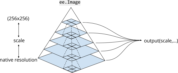
Image Pyramids
Image assets in Earth Engine exist at multiple scales, in image pyramids . The pyramiding policy (represented by dashed lines in Figure 1) determines how each pixel at a given level of the pyramid is computed from the aggregation of a 2x2 block of pixels at the next lower level. For continuous valued images, the pixel values of upper levels of the pyramid are the mean of pixels at the next lower level. For discrete valued images, pixel values of upper levels of the pyramid are a sample (usually the top left pixel) of pixels at the next lower level.
The lowest level of the image pyramid represents image data at native resolution, when it is ingested into Earth Engine. During ingestion, the data are aggregated (according to the pyramiding policy) to create higher pyramid levels. The data are aggregated until the entire image fits within a 256x256 pixel tile. When you use an image in your code, Earth Engine chooses a level of the pyramid with the closest scale less than or equal to the scale specified by your analysis and resamples (using nearest neighbor by default) as necessary.
Scale of analysis
Scale of analysis in Earth Engine is determined on a "pull" basis. The scale at which
to request inputs to a computation is determined from the output. For example, if you
add an image to the Code Editor or geemap map element, the zoom level of the map determines
the scale at which inputs are requested from the image pyramid. For other computations, you
specify scale
as an argument. For example, using the NIR band of a Landsat
image, which has 30 meters native resolution:
Code Editor (JavaScript)
 var

 image

 =

 ee
 .
 Image
 (
 'LANDSAT/LC08/C02/T1_TOA/LC08_044034_20140318'
 ).
 select
 (
 'B4'
 );
 var

 printAtScale

 =

 function
 (
 scale
 )

 {

 print
 (
 'Pixel value at '
 +
 scale
 +
 ' meters scale'
 ,

 image
 .
 reduceRegion
 ({

 reducer
 :

 ee
 .
 Reducer
 .
 first
 (),

 geometry
 :

 image
 .
 geometry
 ().
 centroid
 (),

 // The scale determines the pyramid level from which to pull the input

 scale
 :

 scale

 }).
 get
 (
 'B4'
 ));
 };
 printAtScale
 (
 10
 );

 // 0.10394100844860077
 printAtScale
 (
 30
 );

 // 0.10394100844860077
 printAtScale
 (
 50
 );

 // 0.09130698442459106
 printAtScale
 (
 70
 );

 // 0.1150854229927063
 printAtScale
 (
 200
 );

 // 0.102478988468647
 printAtScale
 (
 500
 );

 // 0.09072770178318024
 import

 ee
 import

 geemap.core

 as

 geemap
Colab (Python)
 image
 =
 ee
 .
 Image
 (
 'LANDSAT/LC08/C02/T1_TOA/LC08_044034_20140318'
 )
 .
 select
 (
 'B4'
 )
 def

 print_at_scale
 (
 scale
 ):
 display
 (
 f
 'Pixel value at
 {
 scale
 }
 meters scale'
 ,
 image
 .
 reduceRegion
 (
 reducer
 =
 ee
 .
 Reducer
 .
 first
 (),
 geometry
 =
 image
 .
 geometry
 ()
 .
 centroid
 (),
 # The scale determines the pyramid level from which to pull the input
 scale
 =
 scale
 ,
 )
 .
 get
 (
 'B4'
 ),
 )
 print_at_scale
 (
 10
 )
 # 0.10394100844860077
 print_at_scale
 (
 30
 )
 # 0.10394100844860077
 print_at_scale
 (
 50
 )
 # 0.09130698442459106
 print_at_scale
 (
 70
 )
 # 0.1150854229927063
 print_at_scale
 (
 200
 )
 # 0.102478988468647
 print_at_scale
 (
 500
 )
 # 0.09072770178318024
In this example, note that the pixel value at a constant location (the image centroid) varies based on scale. This is due to the fact that different pyramid levels are selected for different scales. For similar scales, nearest neighbor resampling results in the same pixel value being returned. The important point is that by varying the scale, different image inputs are requested.
When you visualize an image by adding it to the map, Earth Engine determines scale from the zoom level. Consider the following simple example, which simply displays a Landsat image:
Code Editor (JavaScript)
 var

 image

 =

 ee
 .
 Image
 (
 'LANDSAT/LC08/C02/T1_TOA/LC08_044034_20140318'
 );
 Map
 .
 centerObject
 (
 image
 ,

 17
 );
 Map
 .
 addLayer
 (
 image
 ,

 {
 bands
 :

 [
 'B4'
 ,

 'B3'
 ,

 'B2'
 ],

 max
 :

 0.35
 },

 'image'
 );
 import

 ee
 import

 geemap.core

 as

 geemap
Colab (Python)
 image
 =
 ee
 .
 Image
 (
 'LANDSAT/LC08/C02/T1_TOA/LC08_044034_20140318'
 )
 m
 =
 geemap
 .
 Map
 ()
 m
 .
 center_object
 (
 image
 ,
 17
 )
 m
 .
 add_layer
 (
 image
 ,
 {
 'bands'
 :
 [
 'B4'
 ,
 'B3'
 ,
 'B2'
 ],
 'max'
 :
 0.35
 },
 'image'
 )
 m
The map starts zoomed all the way in, such that the native resolution pixels are clearly visible. Zooming out far enough will not display the same pixels, but will instead display higher levels of the image pyramid. It is also worth noting that the Code Editor and geemap maps use the maps mercator (EPSG:3857) projection, so the appropriate level of the image pyramid also needs to be reprojected prior to display. Learn more about how Earth Engine handles projections from the projections doc .