
PR

jinsan0716
『JINさんの陽蜂農遠日記』にアクセスありがとう ございます。 このブログは、 陽:太陽光発電、 蜂:趣味の養蜂、 農:菜園、花、スロー&アクティブシニアライフ、 遠:旅行、 を中心とした備忘録を兼ねた17年間にわたる毎日のブログ(雑記帳)です。 書き込んでいただける方は、写真下の『コメントを書く』から 気楽に、ご感想、ご意見ご質問等を書き込んでいただきたく。
Keyword Search
▼キーワード検索
Comments
2025年版・岡山大学…
 New!
隠居人はせじぃさん
New!
隠居人はせじぃさん
続日本100名城東北の… New! オジン0523さん
【甥のステント挿入…
New!
Gママさん
ムベの実を開くコツ…
noahnoahnoahさん
エコハウスにようこそ ecologicianさん
New!
隠居人はせじぃさん続日本100名城東北の… New! オジン0523さん
【甥のステント挿入…
New!
Gママさんムベの実を開くコツ…
noahnoahnoahさんエコハウスにようこそ ecologicianさん
Calendar
2025.08.05

カテゴリ: 海外旅行
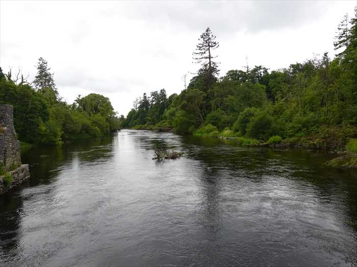
さらに、Cong川沿いの公園を散策する。
自然素材(おそらく柳や何かの蔓)で作られた鳥のオブジェ。
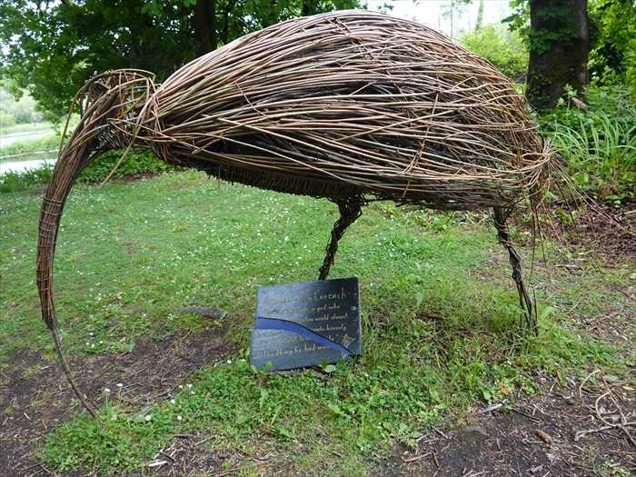
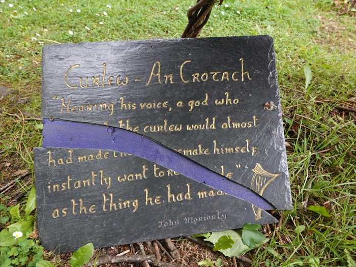
「Curlew – An Crotach
“Hearing his voice, a god who …
… the curlew would almost …
… had made the … remake himself,
… instantly want to be made …
… as the thing he had made.”
John Moriarty」 と。
【「ダイシャクシギ ― アン・クロハ(アイルランド語で“Curlew”)
ダイシャクシギの姿に心を奪われ、
自ら創造したものによって自分を作り変え、
ついにはその創造物そのものになりたいと願った。」
― ジョン・モリアーティ】
Cong川にかかる木橋を渡りながら、上流を見る。
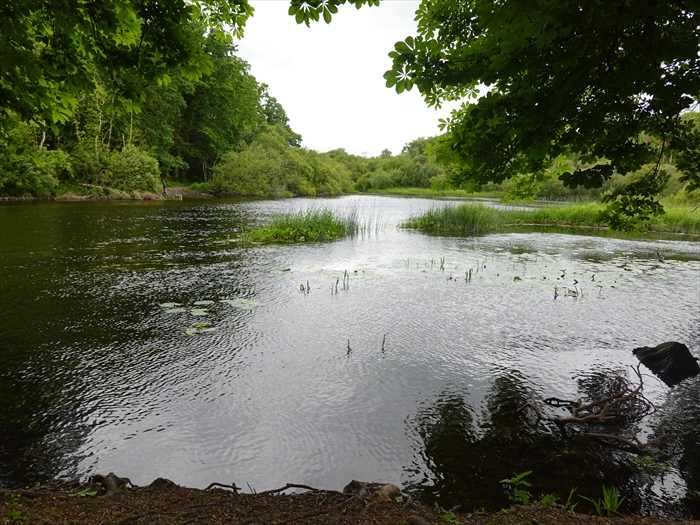
橋をわたる旅友。
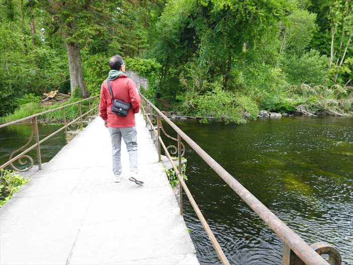
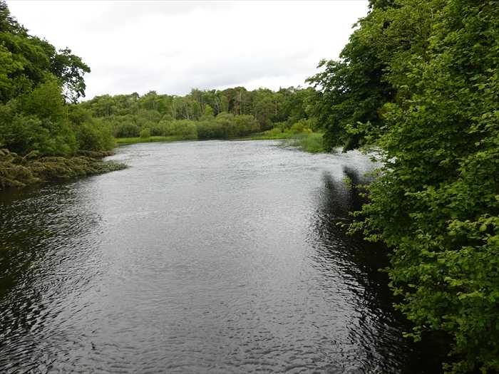
下流側。
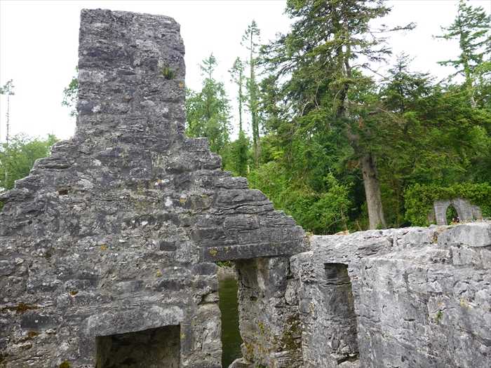
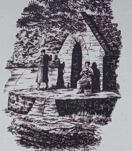
下流側にあった「 Monks’ Fishing House(修道士の釣り小屋) 」を橋の上から見る。
![Monks fishing house, Cong Abbey, County Mayo, Connacht, Republic of Ireland, Europe[20062057739]の写真・イラスト素材|アマナイメージズ](https://static.amanaimages.com/imgroom/cen3tzG4fTr7Gtw1PoeRer/20062/20062057739.jpg)
移動して。

入口に近づいて川の中央側をズーム。
Monk’s Fishing House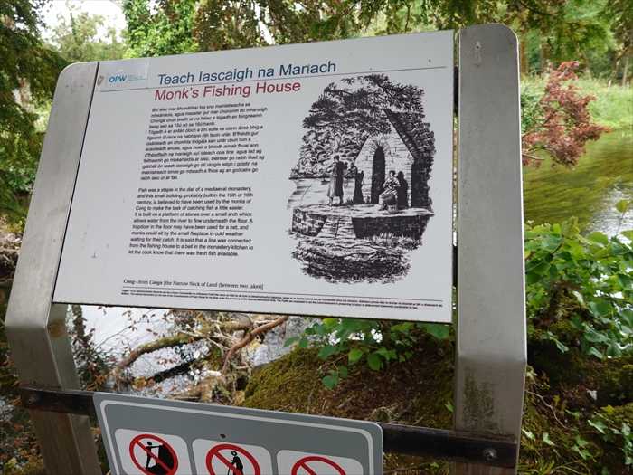
「Monks’ Fishing House(修道士の釣り小屋)」の絵に近づいて。
再び Lough Corrib・コリブ湖 に繋がる下流側を。
中央奥に見えた三連アーチの窓は Cong Abbeyの教会堂の東壁(祭壇側) 。
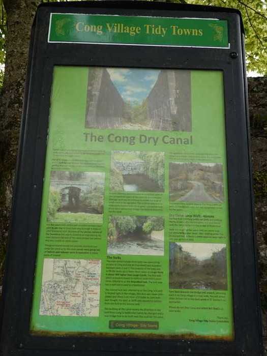
Cong Dry Canal(コング・ドライ・キャナル/コングの乾いた運河) 」案内板。
「 The Cong Dry Canal
flora and fauna.」
【 コングの乾いた運河(Cong Dry Canal)
なっています。】
「For five years both skilled and unskilled workers were paid 4p per day to blast their way through 4 miles of solid limestone rock.
自然素材(おそらく柳や何かの蔓)で作られた鳥のオブジェ。
「Curlew – An Crotach
“Hearing his voice, a god who …
… the curlew would almost …
… had made the … remake himself,
… instantly want to be made …
… as the thing he had made.”
John Moriarty」 と。
【「ダイシャクシギ ― アン・クロハ(アイルランド語で“Curlew”)
ダイシャクシギの姿に心を奪われ、
自ら創造したものによって自分を作り変え、
ついにはその創造物そのものになりたいと願った。」
― ジョン・モリアーティ】
Cong川にかかる木橋を渡りながら、上流を見る。
橋をわたる旅友。
下流側。
下流側にあった「 Monks’ Fishing House(修道士の釣り小屋) 」を橋の上から見る。
移動して。
入口に近づいて川の中央側をズーム。
Monk’s Fishing House
We owe our knowledge for this rare monument to an anonymous writer who visited
Cong Abbey and its surroundings in 1855.
Cong Abbey and its surroundings in 1855.
Cong is unique in that the River Cong flows both above and below ground. This is due to
its location on an esker ridge – a narrow, winding ridge formed by glacial meltwater
streams – between Lough Mask and Lough Corrib.
its location on an esker ridge – a narrow, winding ridge formed by glacial meltwater
streams – between Lough Mask and Lough Corrib.
The fast-flowing River Cong is an ideal place to glimpse a salmon leaping or a heron
dive to bring a fish to the riverbank.
dive to bring a fish to the riverbank.
The building before you, called the Monk’s Fishing House, is believed to have been
constructed in the 15th or 16th century. The monks are thought to have sat inside,
dry and sheltered, while fishing through an opening in the floor. A fireplace provided
warmth in cold weather.
constructed in the 15th or 16th century. The monks are thought to have sat inside,
dry and sheltered, while fishing through an opening in the floor. A fireplace provided
warmth in cold weather.
Fish was a staple in the diet of a medieval monastery. It was an invaluable protein,
particularly for the 110 days of the year when the eating of meat was forbidden.
The Fishing House is built on piers at the confluence of a small stream and
the River Cong, and it is part of the stone wall and arch which forms the boundary of
the river terrace.
particularly for the 110 days of the year when the eating of meat was forbidden.
The Fishing House is built on piers at the confluence of a small stream and
the River Cong, and it is part of the stone wall and arch which forms the boundary of
the river terrace.
A square hole in the floor allowed a net to be lowered into the water. The building is
believed to have been connected by a line to a bell in the monastery kitchen to let
the cook know that there was fresh fish available.」
【 修道士の釣り小屋
believed to have been connected by a line to a bell in the monastery kitchen to let
the cook know that there was fresh fish available.」
【 修道士の釣り小屋
この珍しい建造物に関する知識は、1855年にコング修道院とその周辺を訪れた匿名の旅行者の
記録によって伝えられています。
記録によって伝えられています。
コングは、川が地上と地下の両方を流れるという、非常に珍しい地形を持っています。
これは、ロッホ・マスク湖とロッホ・コリブ湖の間に位置するエスカー地形(氷河の融水に
よって形成された細長い丘)によるものです。
これは、ロッホ・マスク湖とロッホ・コリブ湖の間に位置するエスカー地形(氷河の融水に
よって形成された細長い丘)によるものです。
急流のコン川では、跳ねるサケや、魚を捕えるサギの姿が見られることもあります。
この前にある建物「修道士の釣り小屋」は、15~16世紀に建てられたと考えられています。
修道士たちは、この小屋の中で、床に開けられた穴から釣りをしながら、雨風をしのいで座って
いたとされています。小屋内には暖炉があり、寒い季節にも暖を取ることができました。
修道士たちは、この小屋の中で、床に開けられた穴から釣りをしながら、雨風をしのいで座って
いたとされています。小屋内には暖炉があり、寒い季節にも暖を取ることができました。
魚は、中世の修道院の食事において重要なタンパク源でした。特に年間110日間の「肉の摂取が
禁じられた日(斎日)」には、魚が欠かせない食材でした。
禁じられた日(斎日)」には、魚が欠かせない食材でした。
この釣り小屋は、小さな支流とコング川の合流地点にある石造りの土台の上に建てられており、
川沿いのテラスを囲む石の壁とアーチの一部でもあります。
川沿いのテラスを囲む石の壁とアーチの一部でもあります。
床に開けられた四角い穴から網を下ろして川に垂らすことができました。また、修道院の
厨房にはベルがつながっていて、魚が獲れたら鳴らして知らせたとも言われています。】
厨房にはベルがつながっていて、魚が獲れたら鳴らして知らせたとも言われています。】
「Monks’ Fishing House(修道士の釣り小屋)」の絵に近づいて。
再び Lough Corrib・コリブ湖 に繋がる下流側を。
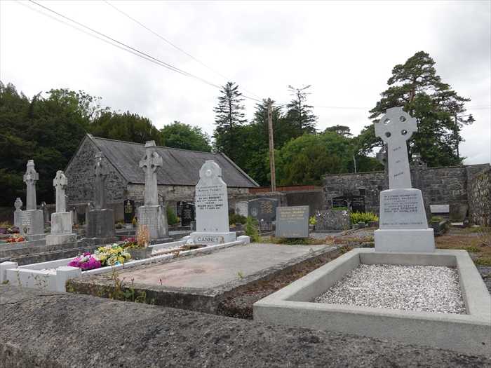
引き返して、 「Cong Abbey(コング修道院)」の墓地
まで戻る。
背景には石造りの小礼拝堂または納骨堂?
墓石には典型的なケルト十字(Celtic Cross)
が数多く並んでいた。
中央奥に見えた三連アーチの窓は Cong Abbeyの教会堂の東壁(祭壇側) 。
Cong Dry Canal(コング・ドライ・キャナル/コングの乾いた運河) 」案内板。
「 The Cong Dry Canal
The Cong Canal was begun in the 1840s in an attempt to link Lough Mask and
Lough Corrib by a navigable waterway.
Lough Corrib by a navigable waterway.
However, because of the porous nature of the limestone bedrock, water leaked away,
and the canal was never completed.
Today the canal is dry and has become a beautiful woodland walk with a wide variety ofand the canal was never completed.
flora and fauna.」
【 コングの乾いた運河(Cong Dry Canal)
コング運河は、ラフ・マスク湖(Lough Mask)とラフ・コリブ湖(Lough Corrib)を
航行可能な水路で結ぶために、1840年代に建設が始められました。
航行可能な水路で結ぶために、1840年代に建設が始められました。
しかし、石灰岩の地盤が多孔質であったため、水が漏れ出し、運河は完成しませんでした。
現在ではこの運河跡は美しい森林の散策路となっており、多種多様な植物や動物の生息地となっています。】
「For five years both skilled and unskilled workers were paid 4p per day to blast their way through 4 miles of solid limestone rock.
Because of the porous nature of the limestone this was to become an engineering disaster because the bed of the canal proved too polous and was unable to retain water.
The government would not provide money to concrete the canal as by this time canals were going out of fashion and railway were in operation in many parts of Ireland.」
【5年間にわたり、熟練工も未熟練工も、1日あたりわずか4ペンスの賃金で、4マイル(約6.4km)
に及ぶ堅固な石灰岩を爆破しながら掘り進みました。
【5年間にわたり、熟練工も未熟練工も、1日あたりわずか4ペンスの賃金で、4マイル(約6.4km)
に及ぶ堅固な石灰岩を爆破しながら掘り進みました。
しかし、石灰岩が多孔質だったため、これはやがて技術的な大失敗へとつながります。
というのも、運河の底があまりにも穴だらけで、水を保持することができなかったのです。
さらに悪いことに、当時すでに運河は時代遅れとなりつつあり、アイルランド各地では鉄道が
普及し始めていたため、政府はこの運河をコンクリートで補修するための資金を出そうとは
しませんでした。】
「In April 1854 the commissioners directed that work on the navigational aspect of the
canal be discontinued;drainage work was to continue to enable the level of lough mask
to be regulated. This artificial waterway so elaborately finished with sluice-gates,
substantial locks of cut stone and arched bridges has become known as the dry canal.」
【1854年4月、委員会(※公共事業委員会)は、運河の航行目的に関する工事を中止するよう
命じました。ただし、ラフ・マスク湖の水位を調整できるようにするための排水工事は続けられる
ことになりました。
この人工の水路は、水門(スルースゲート)、切石で造られた頑丈な閘門(ロック)、アーチ型の
橋などが精巧に仕上げられていたにもかかわらず、「乾いた運河(ドライ・キャナル)」として
知られるようになったのです。】
「 The locks
橋などが精巧に仕上げられていたにもかかわらず、「乾いた運河(ドライ・キャナル)」として
知られるようになったのです。】
「 The locks
The main works include three locks two stone bridges (one at Cong and one at Drumsheel)
and aqueduct between locks 2 and 3. The purpose of th locks was to lift the boats up or
lower them down as Lough Mask is about 36ft higher than Lough Corrib.The firstt lock
and aqueduct between locks 2 and 3. The purpose of th locks was to lift the boats up or
lower them down as Lough Mask is about 36ft higher than Lough Corrib.The firstt lock
which is located closest to Ashford castte and is sometimes referred to as the Strandford
lock.The lock now has a roof and is used as a boathouse.
lock.The lock now has a roof and is used as a boathouse.
The second lock was referred to the Cong lock and is located right in the village. This lock
was never completed and there is no trace of it today as Lord Ardilaun bought the land in
1876 and closed the section from the first to the second lock.
そのまま道なりにまっすぐ進みましょう。
まもなく道は右にカーブし始めますが、その地点で左側に小道があり、それが「ギネス・タワー(Guinness Tower)」へと続いています。
タワーの階段では、小さなお子様に十分ご注意いただき、また、森の中ではゴミを絶対に捨てない
ようお願いいたします。
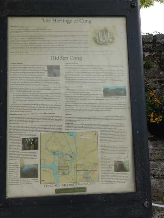
「 The Heritage of Cong
in the 19th century, and the filming of “The Quiet Man” in the village in 1951 ensured
that the village continues to attract visitors from around the world in the 21st century.」
「 Hidden Cong 」
was never completed and there is no trace of it today as Lord Ardilaun bought the land in
1876 and closed the section from the first to the second lock.
The building of the canal meant the direction of the road from Cong to Ballinrobe had to
be changed and a new bridge had to be built over this road for the canal.」
【 閘門
主要な構造物には、3つの閘門(ロック)、2つの石橋(1つはコング、もう1つはドラムシール)、
および第2と第3のロックの間にある水路橋(アクアダクト)が含まれています。
be changed and a new bridge had to be built over this road for the canal.」
【 閘門
主要な構造物には、3つの閘門(ロック)、2つの石橋(1つはコング、もう1つはドラムシール)、
および第2と第3のロックの間にある水路橋(アクアダクト)が含まれています。
ラフ・マスク湖はラフ・コリブ湖より約36フィート(約11メートル)高いため、船を昇降させる
ためにロック(閘門)が設置されました。
ためにロック(閘門)が設置されました。
第1のロックはアシュフォード城に最も近い場所にあり、ストランドフォード・ロック
(Strandford Lock)とも呼ばれることがあります。
(Strandford Lock)とも呼ばれることがあります。
このロックには現在屋根がかけられており、ボートハウスとして使用されています。
第2のロックは「コング・ロック(Cong Lock)」と呼ばれ、村の中心部に位置していました。
このロックは完成することはなく、現在では跡形も残っていません。
というのも、1876年にアーディローン卿(Lord Ardilaun)がその土地を買い取り、第1と第2の
ロックの区間を閉鎖したためです。
ロックの区間を閉鎖したためです。
この運河の建設により、コングからバリンローブへ向かう道路の方向が変更され、その道路の
上に運河を通すための新しい橋を建設する必要が生じました。】
「The aqueduct was built to allow the river form from the rising water below Cong to
flow under the new canal.This all that remains today of the aqueduct.
【このアクアダクト(水路橋)は、コングの下から湧き出す水が「フォーム川(River Form)」
となって流れるために、その川が新たに建設された運河の下を通れるように造られたものでした。
上に運河を通すための新しい橋を建設する必要が生じました。】
「The aqueduct was built to allow the river form from the rising water below Cong to
flow under the new canal.This all that remains today of the aqueduct.
The third lock is located close to the Cong pubiic car park,on the Galway road and
was completed except for the gates.」
was completed except for the gates.」
【このアクアダクト(水路橋)は、コングの下から湧き出す水が「フォーム川(River Form)」
となって流れるために、その川が新たに建設された運河の下を通れるように造られたものでした。
今日では、このアクアダクトの名残はこの部分だけが残っています。
アシュフォード城の狩猟管理人が眺望に利用する以外は、この塔は裕福な男の「気まぐれな建築物
(フォリー)」にすぎませんが、石細工の仕上がりは驚くほど見事です。
この塔の内部は非常に珍しく、石造りの螺旋階段と屋根の下にある小さな八角形の部屋しか
ほとんど存在しません。
コンウッズの頂上にある屋上まで、螺旋階段には83段の階段があります。】
「Continue straight on past this green gate on your left and follow walkway in to the
第3のロック(閘門)は、ゴールウェイ方面道路沿い、コングの公共駐車場のすぐ近くに位置して
おり、ゲート(門扉)を除けば完成していました。】
「 Dry Canal Loop Walk. 40mins
おり、ゲート(門扉)を除けば完成していました。】
「 Dry Canal Loop Walk. 40mins
Starting from the Cong public car park, and walking North,down to the old lock gate, it is
possible to walk the old canal bed to the bridge at Drumsheel,
possible to walk the old canal bed to the bridge at Drumsheel,
Walk the length of the canal until you reach large cut stone bridge over thead.
After walking under the Drumsheel bridge there is stone steps on your right totake you
up the road.」
【 ドライ・キャナル・ループ・ウォーク(所要時間:約40分)
After walking under the Drumsheel bridge there is stone steps on your right totake you
up the road.」
【 ドライ・キャナル・ループ・ウォーク(所要時間:約40分)
コングの公共駐車場からスタートし、北方向へ歩いていくと、旧ロックゲート(閘門)に下りる
道があります。
道があります。
そこから古い運河の底(運河跡)をたどって、ドラムシール(Drumsheel)の橋まで歩くことが
できます。
できます。
運河の全長を歩いていくと、頭上に切石で造られた大きな橋が見えてきます。
このドラムシール橋の下をくぐったあと、右手に石段があり、そこを登ると車道(道路)に出る
ことができます。】
「Turn back towards the bridge and cross it, returning back in to Cong village in a loop
walk. You will arrive down School Hill to the duck pond at 0 ' Connor's supermarket.
ことができます。】
「Turn back towards the bridge and cross it, returning back in to Cong village in a loop
walk. You will arrive down School Hill to the duck pond at 0 ' Connor's supermarket.
permarket.
Please do not litter Cong and LEAVE NO TRACE on your walks.
Thankyou、
Cong Village Tidy Towns Committee」
【橋の方へ引き返して渡り、ループ状にコング村へ戻ってください。
【橋の方へ引き返して渡り、ループ状にコング村へ戻ってください。
やがてスクール・ヒル(School Hill)を下って、オコナー・スーパーマーケット(O'Connor's Supermarket)前のカモの池に到着します。
コングの自然を汚さず、「痕跡を残さない行動(LEAVE NO TRACE)」を心がけてください。
ご協力ありがとうございます。
コング村 環境美化委員会(Cong Village Tidy Towns Committee)】
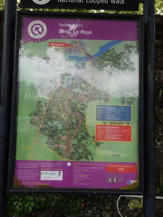
この案内板は「Trailhead 31 – Cong, Co. Mayo(トレイルヘッド31 – メイヨー県コング村)」の
ナショナル・ループ・ウォーク(National Looped Walk)。
・Loop 131a:Nature Loop
・Loop 131b:igeon Hole Loop
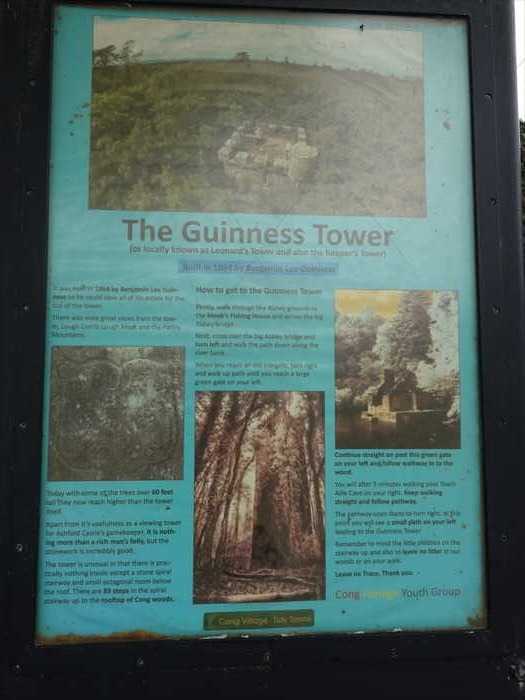
「 The Guinness Tower
この案内板は「Trailhead 31 – Cong, Co. Mayo(トレイルヘッド31 – メイヨー県コング村)」の
ナショナル・ループ・ウォーク(National Looped Walk)。
・Loop 131a:Nature Loop
・Loop 131b:igeon Hole Loop
「 The Guinness Tower
(or locally known as Leonard's Tower and also the Keeper's Tower)
Built in 1864 by Benjamin Lee Guinness
【 ギネス塔
It was built in 1864 by Benjamin Lee Guinness so he could view all of his estate for the
top of the tower.
There was once great views from the tower, Lough Corrib Lough Mask and the partry
Mountains.」【 ギネス塔
(地元では「レナードの塔」または「番人の塔」とも呼ばれる)
1864年、ベンジャミン・リー・ギネスによって建設された
この塔は、ベンジャミン・リー・ギネスが自身の領地全体を見渡せるように、1864年に建てられ
ました。かつては、塔の上からコリブ湖、マスク湖、そしてパートリー山脈を一望できる絶景が
広がっていました。】
「Today with some of the trees over 60 feet tall fhey now reach higher than the tower
ました。かつては、塔の上からコリブ湖、マスク湖、そしてパートリー山脈を一望できる絶景が
広がっていました。】
「Today with some of the trees over 60 feet tall fhey now reach higher than the tower
itself.
Apart from it's usefulness as a viewing tower for Ashford castle's gamekeeper, it is
nothing more than a rich man's folly,but the stonework is incredibly good.
nothing more than a rich man's folly,but the stonework is incredibly good.
The tower is unusual in that there is practically nothing inside except a stone spiral
stairway and small octagonal room below the loof. There are 83 steps in the spiral
stairway up to the rooftop of Cong woods.」
【現在では、高さ60フィート(約18メートル)を超える木々がいくつもあり、それらはすでに
塔の高さを超えています。
【現在では、高さ60フィート(約18メートル)を超える木々がいくつもあり、それらはすでに
塔の高さを超えています。
アシュフォード城の狩猟管理人が眺望に利用する以外は、この塔は裕福な男の「気まぐれな建築物
(フォリー)」にすぎませんが、石細工の仕上がりは驚くほど見事です。
この塔の内部は非常に珍しく、石造りの螺旋階段と屋根の下にある小さな八角形の部屋しか
ほとんど存在しません。
コンウッズの頂上にある屋上まで、螺旋階段には83段の階段があります。】
「Continue straight on past this green gate on your left and follow walkway in to the
wood.
You will after 5 minutes walking passTeach Aille Cave on your right. Keep walking
straight and follow pathway.
The pathway soon starts to turn right,at this point you will see a small pass on your
left leading to the GuinnessTower.
Remember to mind the little children on the stairway up and also to leave no litter in
our woods on your walk.
Leave no Trace,Thank you.」
【左手にある緑の門を通り過ぎ、そのまま真っすぐ小道に沿って森の中へ進んでください。
約5分ほど歩くと、右手に「ティーチ・アイル洞窟(Teach Aille Cave)」が見えてきます。our woods on your walk.
Leave no Trace,Thank you.」
【左手にある緑の門を通り過ぎ、そのまま真っすぐ小道に沿って森の中へ進んでください。
そのまま道なりにまっすぐ進みましょう。
まもなく道は右にカーブし始めますが、その地点で左側に小道があり、それが「ギネス・タワー(Guinness Tower)」へと続いています。
タワーの階段では、小さなお子様に十分ご注意いただき、また、森の中ではゴミを絶対に捨てない
ようお願いいたします。
「痕跡を残さない(Leave no Trace)」を守りましょう。ありがとうございました。】
「 The Heritage of Cong
Welcome to Cong
or Cunga Feichin — the narrow isthmus of St. Fechin.
Cong and the area around the village is rich in historical sites spanning over 5,500 years.
Looking around you, there is the Abbey which dates from the 12th century, the old
Church of Ireland which originally dates from the 18th century, and the Court House
which dates from 1867.
Church of Ireland which originally dates from the 18th century, and the Court House
which dates from 1867.
Evidence of early settlement in the local area is still visible. Dating from around 3500 BC
are the Court Tombs at Killimor and Toberbiroge. From the later Neolithic and early
Bronze Age are the Hilltop Cairns at Ballymagibbon and the Glebe Stone Circles at
Nymphsfield. Evidence of settlement during the later Bronze Age and Iron Age can be
seen in the Crannogs at Lisloughrey and burial sites at Aghalahard.
From the 5th century onwards the local area became an important Christian centre.
Early Christian structures dating from this time can be found on the island of Inchagoill
in Lough Corrib. The Abbey was originally founded in the 7th century although most of
the buildings that can be seen today date from the 13th century to the 16th century.
Ruaidri Ua Conchobair — the last High King of Ireland — spent the last years of his life
at the Abbey and died here in 1198. The Abbey was also home to important Irish
artefacts like the Cross of Cong, which today can be seen in the National Museum of
Ireland in Dublin.
The Abbey was suppressed in 1542, but Cong remained an important strategic location
and was garrisoned by Sir Richard Bingham in the late 16th century. The ruins of castles
dating from the 15th and 16th century can be found at Aghalahard and Ballykine
between Cong and Clonbur.
The ruins and caves became the focus of interest for many visitors to the West of Irelandand was garrisoned by Sir Richard Bingham in the late 16th century. The ruins of castles
dating from the 15th and 16th century can be found at Aghalahard and Ballykine
between Cong and Clonbur.
in the 19th century, and the filming of “The Quiet Man” in the village in 1951 ensured
that the village continues to attract visitors from around the world in the 21st century.」
「 Hidden Cong 」
The Abbey Graveyard
The grounds and interior of the Abbey have been the final resting place of the people of
Cong and its neighbourhood for many centuries. Some gravestone memorials dating
back to the early eighteenth century can still be deciphered. For example, in the centre
of the chancel, on your left as you enter through the archway, is a beautifully carved
slab stone commemorating James Lynch, Abbot of Cong, who died in 1703. Close by,
part of a family crest — a right-angled arm with the hand holding a cross — identifies the gravestone of members of the McDonnell family of Ahalard Castle.
George McNamara, a legendary local "Robin Hood" character who died in 1760, was buried close to the east-facing chancel window, while members of his daughter’s family, the Jenings of Fountainhill, lie close to the sedilia — their name just legible still. In a small annexe next to the nearby doorway lies the gravestone of Thomas Bermingham of Rosshill, who died on 23 December 1705 aged seven. He was a grandson of John Browne, who founded the
town of Westport.
town of Westport.
A short distance away, diagonally opposite the chancel window, is a large Celtic cross
marking the grave of Michael O’Brien, killed on the Partry Mountains during the War of Independence. His gravestone inscription is in the Irish language. Translated it reads
as follows:
marking the grave of Michael O’Brien, killed on the Partry Mountains during the War of Independence. His gravestone inscription is in the Irish language. Translated it reads
as follows:
“In fond and proud remembrance of the brave and noble freedom fighter, Michael O’Brien,
volunteer of the West Mayo Brigade of the Irish Republican Army.
He willingly and bravely gave up his life in the heat of battle
for the green sod of his country, fighting against the English
on the slopes of Tourmakeady on the 3rd of May 1921 at the age of 22.
God be with you, true Irish hero, you were never overcome and you did not yield in the
hour of need.”
hour of need.”
His mother erected this monument.
A white marble plaque, on the high wall in the lower part of the graveyard, remembers
Mary Burke, who for fifty years worked at Moytura House, the home of Sir William Wilde,
father of Oscar. Dr. Edward Murphy, who served the medical needs of the people of
Cong from 1925 to 1954, rests with his wife in a grave in the next section of the graveyard
— as do many others who lived and worshipped in this small village over the years.
Explore their epitaphs.
Stained Glass Window in Saint Mary of the Rosary Roman Catholic Church, Cong
The light stained glass window of native Irish Art is situated behind the altar.
The window contains a central figure of Christ the King. Insets illustrate events in the life
of the Holy Family. The window was designed by the Irish stained glass artist Harry Clarke.
In 1931 it was installed in the church which stood on the site of the present church.
When the building of the present church was completed in 1973 the Harry Clarke window
was re-erected behind the altar.
Harry Clarke, Ireland's most famous stained glass artist, was born in Dublin in 1889.
His father established a decorating business which included a stained glass division.
Harry left school at the age of 14 and became apprenticed to his father. He studied
stained glass at Dublin Metropolitan School of Art and won gold medals at National
Competitions for his stained glass panels and was awarded a scholarship. Following t
his he toured Europe gaining inspiration for his work while visiting medieval cathedrals
and churches.
After the death of his father, Harry continued to work in the family business with his
brother Walter. Following the sudden death of Walter, the decorating business terminated
in 1930. The business was renamed Harry Clarke Stained Glass Studios Ltd.
brother Walter. Following the sudden death of Walter, the decorating business terminated
in 1930. The business was renamed Harry Clarke Stained Glass Studios Ltd.
Harry had suffered from a “weak chest” for most of his life. He was diagnosed with
tuberculosis in 1929 and travelled to a sanatorium in Davos on two occasions for treatment without improvement in his condition. He left Davos planning to return to Dublin in 1931
but passed away in his sleep in Switzerland, aged 41 years. He was laid to rest
in Switzerland.
tuberculosis in 1929 and travelled to a sanatorium in Davos on two occasions for treatment without improvement in his condition. He left Davos planning to return to Dublin in 1931
but passed away in his sleep in Switzerland, aged 41 years. He was laid to rest
in Switzerland.
Guinness Seat
This circular stone seat by the entrance of Cong Abbey was put in place on the orders of Sir Benjamin Lee Guinness, Irish brewer and philanthropist and one time Lord Mayor of Dublin,
at the site of the old market square in Cong.
at the site of the old market square in Cong.
It is described simply as a rest in texts of the time and was originally shaded by trees.
The Rising of the Waters
Cong is situated on an isthmus between Lough Mask and Lough Corrib.
Streams flow underground from the Mask to the Corrib and rise again in Cong in what is
known locally as “The Rising of the Waters.”
known locally as “The Rising of the Waters.”
The main risings are Poll Tuathail (Polltoothil), Poll an Chuairteil (Pollacuarleale),
Poll Leibin, and Corr na Buinnighe (Cornabany).
Poll Leibin, and Corr na Buinnighe (Cornabany).
To view these wonders of nature, go to the bridge at the northern end of the village
on the road to Clonbur.
on the road to Clonbur.
On the western side of the bridge (i.e. on your left if facing away from the village),
you can see a mild disturbance in the water which marks Poll Tuathail, also referred to
as The Pool of the Turning Waters or The Northern Pool.
you can see a mild disturbance in the water which marks Poll Tuathail, also referred to
as The Pool of the Turning Waters or The Northern Pool.
If you look further west, closer to the old sawmill (now the Salmon Hatchery), you will
notice the more turbulent Poll an Chuairteil, also referred to as The Whirlpool.
notice the more turbulent Poll an Chuairteil, also referred to as The Whirlpool.
The waters that rise from here flow into what is now called Cong River, which then joins
Lough Corrib near Ashford Castle.
Lough Corrib near Ashford Castle.
To the right of the bridge, just a short stroll down the path beside the garage, Poll Leibin
is a very significant rising.
is a very significant rising.
Its waters divide into two streams that encircle the village and join Cong River south of
the Abbey.They are supplemented with a major flow from the spring at Corr na Buinnighe
(The Round Hill of the Oozing Water).
By the 19th century, fairs were also held at Funshinogh in May and September.the Abbey.They are supplemented with a major flow from the spring at Corr na Buinnighe
(The Round Hill of the Oozing Water).
Industry and Commerce in Cong
It is difficult to imagine small villages like Cong being centres of industry and commerce, but before the industrialisation of the 19th century, industry and commerce were located close to markets and energy.
Because Cong is located on an island surrounded by fast-flowing rivers, it soon became
the site for water-powered mills.
the site for water-powered mills.
The first mill is mentioned in a grant of lands in 1568.
By the late 18th century, two grain mills were in operation at The Rising of the Waters.
By the mid-19th century, Cong boasted four millsーtwo Grain Mills,a Tuck Mill (for
processing wool) and a Saw Mill.The last mill in the village closed in the 20th century.
processing wool) and a Saw Mill.The last mill in the village closed in the 20th century.
To the east of the village is the site of another industrial development — the dry canal.
Work on the canal began in 1848 and was halted before completion in 1854.
Efforts to regulate the levels of Lough Mask and ensure power to the mills continued
until 1856.The canal workings — including locks, bridges, and an aqueduct — can still be
seen around the entrance to the car park on the Galway road.
until 1856.The canal workings — including locks, bridges, and an aqueduct — can still be
seen around the entrance to the car park on the Galway road.
The right to hold a market in Cong has existed since the beginning of the 17th century.
Traditionally, Cong also held a fair day on the 1st of August each year.
Cong Caves
The geology of Cong is mainly limestone, and a series of underground rivers flow through
this limestone bedrock.
this limestone bedrock.
Caves have formed as the waters dissolved the limestone beneath, and subsequently t
he roofs of these caves collapsed to expose them to us.
he roofs of these caves collapsed to expose them to us.
The caves are a natural habitat for a wide variety of fauna in the area, especially bats.
There are many local legends associated with the caves around Cong.
The Pigeon Hole
The Pigeon Hole (Poll na gColum) cave is the most famous cave in Cong and is easily
accessible from the village by walking through the wood by the Abbey or by car out
the Clonbur Road.
accessible from the village by walking through the wood by the Abbey or by car out
the Clonbur Road.
It got its name from pigeons nesting in the ivy growing on the walls of the cave.
The deep cavern was made accessible by the construction of 61 stone steps descending
to the underground passage.Water flows through the cave on its underground way to
Lough Corrib, though in summer it can dry up.
The local legend of the “Fairy Trout” or “White Trout” originates from this cave,where it is
I thought that a pair of trout living in the cave were actually young tragic lovers from
the area.One of them, a white trout with gridiron burn marks on her side, was caught by
an English soldier caught her to trying to dismiss the legend that the pair was inseparable
and proceeded to cook her.Upon being left on the hot gridiron, the trout turned into a
grief stricken beautiful young maiden begging to be returned to the cave.
Teach Aille
Teach-Aille Cave, meaning “House of the Cliff”, is found in Cong Wood near the Abbey.
It is a fine example of a natural grotto.From the wide entrance, steps can be seen down
into the water-filled chamber, where it is thought that the monks from the Abbey took
advantage of the cool freshness of the water as their drinking supply.
Kelly’s Cave is situated on the left after the national school on the Galway Road from
the village.It is easily accessible by a pathway from a stile in the wall.The cave is part
natural and part man-made.The entrance has been built up to resemble a souterrain.
Five steps lead to the ground floor.The cave contains two rectangular compartments,
and at the end of the cave four steps lead down to a water source.A hole in the roof
near the end of the cave acts as a natural skylight.Kelly is thought to have been an
outlaw who used the cave to hide from the authorities,or in other stories, a fugitive
who used the cave as a place of refuge after the 1798 rebellion.」
【 コングの遺産
1951年に映画『静かなる男(The Quiet Man)』がこの村で撮影されたことで、21世紀に
入っても世界中から観光客を惹きつけ続けています。
隠されたコング
コング修道院墓地
and at the end of the cave four steps lead down to a water source.A hole in the roof
near the end of the cave acts as a natural skylight.Kelly is thought to have been an
outlaw who used the cave to hide from the authorities,or in other stories, a fugitive
who used the cave as a place of refuge after the 1798 rebellion.」
【 コングの遺産
コングへようこそ。 アイルランド語では Cunga Feichin — 聖フェイキンの「狭い地峡」と
呼ばれます。
呼ばれます。
コングおよびその周辺地域には、5,500年以上にわたる歴史的遺跡が数多く存在します。
周囲を見渡せば、12世紀に築かれた修道院、18世紀にさかのぼるアイルランド国教会の古い教会、
そして1867年建造の裁判所などがあります。
そして1867年建造の裁判所などがあります。
この地域には、紀元前3500年ごろのものとされるキリモーやトバーブリッジのコート・トゥーム
(墓)が現存し、定住の痕跡が見られます。さらに、後期新石器時代および初期青銅器時代の
ものとされるバリーマギボンの丘上ケルン(石塚)やニンフスフィールドのストーンサークルも
残っています。後期青銅器時代や鉄器時代の定住の証拠は、リスラフリーのクラノグ(人工島)や
アガラハードの埋葬地に見ることができます。
(墓)が現存し、定住の痕跡が見られます。さらに、後期新石器時代および初期青銅器時代の
ものとされるバリーマギボンの丘上ケルン(石塚)やニンフスフィールドのストーンサークルも
残っています。後期青銅器時代や鉄器時代の定住の証拠は、リスラフリーのクラノグ(人工島)や
アガラハードの埋葬地に見ることができます。
5世紀以降、この地域はキリスト教の重要な中心地となりました。この時期の初期キリスト教
建築は、ロッホ・コリブ湖内のインチャゴイル島に今も残っています。コング修道院は7世紀に
創設されたと伝えられますが、現在見られる建物の大部分は13~16世紀にかけてのものです。
アイルランド最後の上王ルアドリ・ウア・コンホバールは晩年をこの修道院で過ごし、1198年に
ここで亡くなりました。修道院はまた、「コングの十字架(Cross of Cong)」のような
アイルランドの重要な聖遺物の保管場所でもありました。十字架は現在、ダブリンの国立博物館に
所蔵されています。
建築は、ロッホ・コリブ湖内のインチャゴイル島に今も残っています。コング修道院は7世紀に
創設されたと伝えられますが、現在見られる建物の大部分は13~16世紀にかけてのものです。
アイルランド最後の上王ルアドリ・ウア・コンホバールは晩年をこの修道院で過ごし、1198年に
ここで亡くなりました。修道院はまた、「コングの十字架(Cross of Cong)」のような
アイルランドの重要な聖遺物の保管場所でもありました。十字架は現在、ダブリンの国立博物館に
所蔵されています。
修道院は1542年に解散されましたが、コングは戦略的に重要な場所として存続し、16世紀後半
にはリチャード・ビンガム卿によって駐屯地とされました。15~16世紀に築かれた城の遺構が、
コングとクロンバーの間にあるアガラハードとバリキーンに今も残っています。
これらの廃墟や洞窟は、19世紀には西アイルランドを訪れる観光客の関心を集めました。そしてにはリチャード・ビンガム卿によって駐屯地とされました。15~16世紀に築かれた城の遺構が、
コングとクロンバーの間にあるアガラハードとバリキーンに今も残っています。
1951年に映画『静かなる男(The Quiet Man)』がこの村で撮影されたことで、21世紀に
入っても世界中から観光客を惹きつけ続けています。
隠されたコング
コング修道院墓地
修道院の敷地および内部は、長年にわたってコングとその周辺地域の人々の終の住処となって
きました。墓石の中には、18世紀初頭にさかのぼるものもあり、今なお読み取ることができます。
きました。墓石の中には、18世紀初頭にさかのぼるものもあり、今なお読み取ることができます。
たとえば、内陣(祭壇部)の中央、アーチをくぐって左側には、美しく彫られた石板があり、
1703年に亡くなったコング修道院長ジェームズ・リンチを記念しています。その近くには、
家紋の一部とみられる「十字を握った右腕」の彫刻があり、アハラード城のマクドネル家の墓石で
あることが示されています。
1703年に亡くなったコング修道院長ジェームズ・リンチを記念しています。その近くには、
家紋の一部とみられる「十字を握った右腕」の彫刻があり、アハラード城のマクドネル家の墓石で
あることが示されています。
1760年に亡くなった伝説の「ロビン・フッド」的存在であった地元のジョージ・マクナマラは、
東向きの内陣窓の近くに埋葬されており、彼の娘の家族であるジェニングス家
(ファウンテンヒル出身)は、セディリア(礼拝者用座席)のそばに葬られています。
その名はかろうじて判別可能です。
東向きの内陣窓の近くに埋葬されており、彼の娘の家族であるジェニングス家
(ファウンテンヒル出身)は、セディリア(礼拝者用座席)のそばに葬られています。
その名はかろうじて判別可能です。
近くの小さな別室には、1705年12月23日に7歳で亡くなったロスヒルのトーマス・バーミンガムの
墓石があります。彼は、ウエストポートの町を創設したジョン・ブラウンの孫にあたります。
墓石があります。彼は、ウエストポートの町を創設したジョン・ブラウンの孫にあたります。
少し離れた場所、内陣窓の斜め向かいには、独立戦争中にパートリー山地で戦死したマイケル・
オブライエンの墓を示す大きなケルト十字が建っています。墓碑銘はアイルランド語で書かれて
おり、訳文は次のとおりです:
オブライエンの墓を示す大きなケルト十字が建っています。墓碑銘はアイルランド語で書かれて
おり、訳文は次のとおりです:
「勇敢で高潔な自由の戦士マイケル・オブライエンを、誇りと敬愛を込めて追悼する。
彼はアイルランド共和国軍西メイヨー旅団の志願兵であった。
彼は喜んで、そして勇敢に、自国の緑の大地のために戦い、1921年5月3日、トゥアマケイディの
山腹で22歳の若さで命を捧げた。真のアイルランドの英雄よ、あなたは決して屈せず、緊急の時
にも信念を貫いた。神があなたと共にありますように。」
山腹で22歳の若さで命を捧げた。真のアイルランドの英雄よ、あなたは決して屈せず、緊急の時
にも信念を貫いた。神があなたと共にありますように。」
※この記念碑は彼の母親によって建てられました。
墓地の下部、高い石垣には、白い大理石のプレートがあります。そこには、サー・ウィリアム・
ワイルド(オスカー・ワイルドの父)の邸宅「モイチュラ・ハウス」で50年間勤務したメアリー・
バークが記念されています。
ワイルド(オスカー・ワイルドの父)の邸宅「モイチュラ・ハウス」で50年間勤務したメアリー・
バークが記念されています。
また、1925年から1954年までコングの人々の医療を担ったエドワード・マーフィー医師は、
妻とともにその隣の区画に眠っています。小さな村で信仰とともに生きた多くの人々が、そこに
埋葬されています。彼らの墓碑銘をぜひ辿ってみてください。
コングのロザリオ聖マリア・カトリック教会にあるステンドグラス
アイルランド独自の芸術による明るい色調のステンドグラスが、教会の祭壇の背後に設置
されています。この窓には「キリスト王」の中央像が描かれており、周囲の小窓には聖家族の
生涯に関する場面が描かれています。この作品は、アイルランドのステンドグラス作家ハリー・
クラークによってデザインされました。
1931年、このステンドグラスは、現在の教会が建てられる前の教会に設置されました。1973年に
現在の教会が完成した際、このハリー・クラークのステンドグラスは祭壇の背後に再設置
されました。
ハリー・クラークは、アイルランドで最も有名なステンドグラス作家であり、1889年にダブリンで
生まれました。父親は装飾業を営んでおり、その中にステンドグラス部門もありました。
ハリーは14歳で学校を中退し、父親の元で見習いとなりました。
彼はダブリン美術学校でステンドグラスを学び、全国コンクールで金賞を受賞し、奨学金も
得ました。その後、ヨーロッパ中を旅して中世の大聖堂や教会を訪れ、創作の
インスピレーションを得ました。父親の死後、ハリーは兄のウォルターとともに家業を継ぎました。
しかし、1930年にウォルターが急逝したことで、装飾業は終了し、会社は「ハリー・クラーク・
ステンドグラス・スタジオ株式会社」として再出発します。
ハリーは長年「胸の弱さ(=呼吸器系疾患)」に苦しんでおり、1929年には結核と診断されました。
彼は2度にわたりスイス・ダボスの療養所で治療を受けましたが、病状は改善しませんでした。
1931年にダブリンへの帰国を計画していた矢先、スイスで眠るように亡くなりました。
享年41歳。彼はその地に埋葬されました。
彼は2度にわたりスイス・ダボスの療養所で治療を受けましたが、病状は改善しませんでした。
1931年にダブリンへの帰国を計画していた矢先、スイスで眠るように亡くなりました。
享年41歳。彼はその地に埋葬されました。
このステンドグラス作品は、ハリー・クラークの卓越した芸術性と、アイルランドの信仰の
象徴として、現在も教会を訪れる多くの人々を魅了し続けています。
ギネス・シート
この円形の石のベンチは、コング修道院の入口付近にあり、かつての旧市場広場の跡地に設
置されました。設置を命じたのは、アイルランドの醸造家で慈善家、またかつてのダブリン市長
であったサー・ベンジャミン・リー・ギネスです。
当時の記録では、このベンチは単に「休憩所(rest)」として記されており、もとは木陰に
覆われていたとされています。
水が湧き上がる場所
コング村は、ロッホ・マスク湖とロッホ・コリブ湖の間の地峡(isthmus)に位置しています。
水流は地下を通ってマスク湖からコリブ湖へと流れ、その途中、コング村の地下から湧き上がる
現象があり、地元ではこれを「ザ・ライジング・オブ・ザ・ウォーターズ(水の湧出地)」と
呼んでいます。
主要な湧水地点には以下があります:ポル・トゥアハル(Poll Tuathail)、ポル・アン・
クアルテイル(Poll an Chuairteil)、ポル・リービン(Poll Leibin)、コール・ナ・ブインニエ
(Corr na Buinnighe)
この自然現象を観察するには、村の北端、クロンバー方面へ向かう橋まで行ってみてください。
橋の西側(村の外向きに立ったとき左側)には、水面のわずかな揺らぎがあり、これが
「ポル・トゥアハル(転じる水の池/北の池)」と呼ばれる湧き出し口です。
さらに西側、旧製材所(現在のサーモン・ハッチャリー:鮭の孵化場)付近には、より激しい
湧出である「ポル・アン・クアルテイル(渦の池)」があります。ここから湧いた水は
コング川に流れ込み、やがてアッシュフォード城付近でロッホ・コリブに合流します。
橋の右手、小道を少し下ると「ポル・リービン」と呼ばれる重要な湧水があります。この水流は
村を取り囲む2本の川に分かれ、修道院の南側でコング川に合流します。さらに、コール・ナ・
ブインニエ(「にじみ出る水の丘」)の湧水も加わっています。
コング村における産業と商業
今日では想像しにくいですが、コングのような小さな村も、19世紀の産業革命以前には産業と
商業の中心地の一つでした。当時の産業や商業は、市場やエネルギー源の近くに立地して
いたのです。
コング村は急流に囲まれた島のような地形であったため、まもなく水力を利用した製粉所(ミル)
の適地となりました。最初の水車小屋の記録は1568年に土地の文書に登場します。18世紀末には2つの穀物製粉所が、「ザ・ライジング・オブ・ザ・ウォーターズ」の地点で
稼働していました。
19世紀半ばまでには、村には4つの製粉施設が存在しました:
穀物製粉所 ×2、羊毛処理用のタック・ミル、製材所
村内の最後の製粉所は20世紀に閉鎖されました。
村の東側には、別の産業遺構である「ドライ・キャナル(乾いた運河)」があります。この運河の建設は1848年に開始されましたが、1854年に未完成のまま中止されました。
その後もロッホ・マスク湖の水位調整や、製粉所への水力供給を目的とした整備が1856年まで
続きました。
現在でも、閘門(こうもん)や橋、水道橋などの構造物は、ゴールウェイ道路沿いの駐車場入口
付近で見ることができます。
また、コングでの市場開催の権利は、17世紀初頭から存在しており、伝統的に8月1日には大規模な
定期市(フェア)が開催されてきました。
19世紀には、5月と9月にフンシノー(Funshinogh)でも市が開かれるようになりました。
コングの洞窟
コング村の地質は主に石灰岩で構成されており、地下河川がこの石灰岩層を貫いて流れています。
長年にわたって地下水が石灰岩を溶かしたことで、洞窟が形成され、やがてその天井部分が
崩れて地表に現れました。
これらの洞窟は、特にコウモリをはじめとするさまざまな野生動物の生息地にもなっています。
また、これらの洞窟には多くの地元伝承が結びついています。
ピジョン・ホール洞窟 この「ピジョン・ホール(ハトの穴)」は、コングで最も有名な洞窟であり、
村の修道院裏の森を歩くか、クロンバー方面への道路を車で進むと簡単にアクセスできます。
洞窟の名は、壁のツタに巣を作っていたハトたちに由来しています。
内部へは、地下への61段の石段を降りて入ることができます。
この洞窟を通って流れる水は、地下でロッホ・コリブ湖へと続いています。
ただし夏季には水が干上がることもあります。
この洞窟には、「妖精のマス(Fairy Trout)」または「白いマス(White Trout)」と呼ばれる
伝説の魚が住んでいたという話があります。
地元の伝説によれば、この洞窟に住んでいた2匹のマスは、実は悲劇的な恋に落ちた若者の
化身であり、そのうちの1匹は、白いマスで体に焼き網の跡があるとされていました。
ある時、この白いマスをイギリス兵が捕らえ、その伝説を迷信として無視し、焼いて食べようと
しました。ところが、熱い焼き網の上に置かれると、マスは突然、悲しみに暮れる美しい少女の
姿に変わり、「元の洞窟へ帰らせて」と懇願したといいます。
ティーチ・アーリェ
ティーチ・アーリェ洞窟(Teach-Aille Cave)は、「崖の家」という意味の名を持ち、修道院の
近くにあるコングの森(Cong Wood)の中に位置しています。
この洞窟は、自然に形成された石室(グロット)の優れた一例です。
広い入り口からは、水をたたえた地下室へと続く石段が見えます。
ここでは、かつて修道院の僧たちが、その冷たく澄んだ水を飲料水として利用していたと
考えられています。
ケリーの洞窟
ケリーの洞窟は、村からゴールウェイ通り(Galway Road)を進み、国立学校を過ぎて左手側に
あります。壁に設けられた小門(スタイル)から続く小道を通って簡単にアクセスできます。
この洞窟は、自然にできた部分と人工的に掘られた部分が混在しています。入り口は、
スーターリン(地下通路)のような構造に造られています。
中へは5段の階段を下って地面に降ります。
内部には長方形の区画が2つあり、洞窟の奥には水源に続く4段の階段があります。また、洞窟の奥の天井には自然光が差し込む穴があり、天窓(スカイライト)として機能して
います。伝承によると、ケリーという人物はこの洞窟を官憲から逃れるための隠れ家として
使っていた無法者であった、あるいは、1798年の反乱の後に逃亡者としてここに潜んだとも
言われています。】
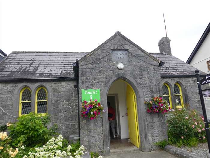
「 Toulist Office
Cong(コング)村の観光案内所として使われている、 旧裁判所(Courthouse)の建物 。
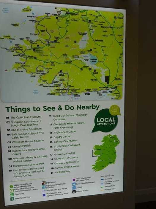
「Things to See & Do Nearby(近隣の見どころ・体験スポット)」。
アイルランド西部・Cong(コング)周辺の観光地を紹介したもの。
「Joyce Country & Western Lakes Geopark Project
(ジョイス・カントリーと西湖のジオパーク・プロジェクト)」に関する 案内パネル 。
象徴として、現在も教会を訪れる多くの人々を魅了し続けています。
ギネス・シート
この円形の石のベンチは、コング修道院の入口付近にあり、かつての旧市場広場の跡地に設
置されました。設置を命じたのは、アイルランドの醸造家で慈善家、またかつてのダブリン市長
であったサー・ベンジャミン・リー・ギネスです。
当時の記録では、このベンチは単に「休憩所(rest)」として記されており、もとは木陰に
覆われていたとされています。
水が湧き上がる場所
コング村は、ロッホ・マスク湖とロッホ・コリブ湖の間の地峡(isthmus)に位置しています。
水流は地下を通ってマスク湖からコリブ湖へと流れ、その途中、コング村の地下から湧き上がる
現象があり、地元ではこれを「ザ・ライジング・オブ・ザ・ウォーターズ(水の湧出地)」と
呼んでいます。
主要な湧水地点には以下があります:ポル・トゥアハル(Poll Tuathail)、ポル・アン・
クアルテイル(Poll an Chuairteil)、ポル・リービン(Poll Leibin)、コール・ナ・ブインニエ
(Corr na Buinnighe)
この自然現象を観察するには、村の北端、クロンバー方面へ向かう橋まで行ってみてください。
橋の西側(村の外向きに立ったとき左側)には、水面のわずかな揺らぎがあり、これが
「ポル・トゥアハル(転じる水の池/北の池)」と呼ばれる湧き出し口です。
さらに西側、旧製材所(現在のサーモン・ハッチャリー:鮭の孵化場)付近には、より激しい
湧出である「ポル・アン・クアルテイル(渦の池)」があります。ここから湧いた水は
コング川に流れ込み、やがてアッシュフォード城付近でロッホ・コリブに合流します。
橋の右手、小道を少し下ると「ポル・リービン」と呼ばれる重要な湧水があります。この水流は
村を取り囲む2本の川に分かれ、修道院の南側でコング川に合流します。さらに、コール・ナ・
ブインニエ(「にじみ出る水の丘」)の湧水も加わっています。
コング村における産業と商業
今日では想像しにくいですが、コングのような小さな村も、19世紀の産業革命以前には産業と
商業の中心地の一つでした。当時の産業や商業は、市場やエネルギー源の近くに立地して
いたのです。
コング村は急流に囲まれた島のような地形であったため、まもなく水力を利用した製粉所(ミル)
の適地となりました。最初の水車小屋の記録は1568年に土地の文書に登場します。18世紀末には2つの穀物製粉所が、「ザ・ライジング・オブ・ザ・ウォーターズ」の地点で
稼働していました。
19世紀半ばまでには、村には4つの製粉施設が存在しました:
穀物製粉所 ×2、羊毛処理用のタック・ミル、製材所
村内の最後の製粉所は20世紀に閉鎖されました。
村の東側には、別の産業遺構である「ドライ・キャナル(乾いた運河)」があります。この運河の建設は1848年に開始されましたが、1854年に未完成のまま中止されました。
その後もロッホ・マスク湖の水位調整や、製粉所への水力供給を目的とした整備が1856年まで
続きました。
現在でも、閘門(こうもん)や橋、水道橋などの構造物は、ゴールウェイ道路沿いの駐車場入口
付近で見ることができます。
また、コングでの市場開催の権利は、17世紀初頭から存在しており、伝統的に8月1日には大規模な
定期市(フェア)が開催されてきました。
19世紀には、5月と9月にフンシノー(Funshinogh)でも市が開かれるようになりました。
コングの洞窟
コング村の地質は主に石灰岩で構成されており、地下河川がこの石灰岩層を貫いて流れています。
長年にわたって地下水が石灰岩を溶かしたことで、洞窟が形成され、やがてその天井部分が
崩れて地表に現れました。
これらの洞窟は、特にコウモリをはじめとするさまざまな野生動物の生息地にもなっています。
また、これらの洞窟には多くの地元伝承が結びついています。
ピジョン・ホール洞窟 この「ピジョン・ホール(ハトの穴)」は、コングで最も有名な洞窟であり、
村の修道院裏の森を歩くか、クロンバー方面への道路を車で進むと簡単にアクセスできます。
洞窟の名は、壁のツタに巣を作っていたハトたちに由来しています。
内部へは、地下への61段の石段を降りて入ることができます。
この洞窟を通って流れる水は、地下でロッホ・コリブ湖へと続いています。
ただし夏季には水が干上がることもあります。
この洞窟には、「妖精のマス(Fairy Trout)」または「白いマス(White Trout)」と呼ばれる
伝説の魚が住んでいたという話があります。
地元の伝説によれば、この洞窟に住んでいた2匹のマスは、実は悲劇的な恋に落ちた若者の
化身であり、そのうちの1匹は、白いマスで体に焼き網の跡があるとされていました。
ある時、この白いマスをイギリス兵が捕らえ、その伝説を迷信として無視し、焼いて食べようと
しました。ところが、熱い焼き網の上に置かれると、マスは突然、悲しみに暮れる美しい少女の
姿に変わり、「元の洞窟へ帰らせて」と懇願したといいます。
ティーチ・アーリェ
ティーチ・アーリェ洞窟(Teach-Aille Cave)は、「崖の家」という意味の名を持ち、修道院の
近くにあるコングの森(Cong Wood)の中に位置しています。
この洞窟は、自然に形成された石室(グロット)の優れた一例です。
広い入り口からは、水をたたえた地下室へと続く石段が見えます。
ここでは、かつて修道院の僧たちが、その冷たく澄んだ水を飲料水として利用していたと
考えられています。
ケリーの洞窟
ケリーの洞窟は、村からゴールウェイ通り(Galway Road)を進み、国立学校を過ぎて左手側に
あります。壁に設けられた小門(スタイル)から続く小道を通って簡単にアクセスできます。
この洞窟は、自然にできた部分と人工的に掘られた部分が混在しています。入り口は、
スーターリン(地下通路)のような構造に造られています。
中へは5段の階段を下って地面に降ります。
内部には長方形の区画が2つあり、洞窟の奥には水源に続く4段の階段があります。また、洞窟の奥の天井には自然光が差し込む穴があり、天窓(スカイライト)として機能して
います。伝承によると、ケリーという人物はこの洞窟を官憲から逃れるための隠れ家として
使っていた無法者であった、あるいは、1798年の反乱の後に逃亡者としてここに潜んだとも
言われています。】
「 Toulist Office
Cong(コング)村の観光案内所として使われている、 旧裁判所(Courthouse)の建物 。
1863年建設の裁判所で、現在は観光インフォメーションセンターとして再利用されています。
窓の形状や石造りのゴシック風デザインは、当時の公的建築物に多く見られたスタイル。
「Things to See & Do Nearby(近隣の見どころ・体験スポット)」。
アイルランド西部・Cong(コング)周辺の観光地を紹介したもの。
01.University Of Galway
ゴールウェイ大学(見学可能)
02.Galway Distillery
ゴールウェイ・ウイスキー蒸溜所
03.Micil Distillery
ミキル蒸溜所(クラフトウイスキー/ポチーン)
04.Galway City Museum
ゴールウェイ市立博物館
05.St. Nicholas Collegiate Church
聖ニコラス教会(アイルランド最古の教区教会)
06.Spanish Arch
スペイン門(中世の海港防御門)
07.Galway Market
ゴールウェイ市場(ローカルフード・クラフト)
08.Aughnanure Castle
アフナニュア城(16世紀の塔城)
09.Lough Mask Distillery
ロッホ・マスク蒸溜所(クラフトスピリッツ)
10.Glenowla Mines & Family Farm Experience
グレノーラ鉱山とファーム体験
11.Galway Cathedral
ゴールウェイ大聖堂
12.University Of Galway
ゴールウェイ大学(見学可能)
13.Galway Distillery
ゴールウェイ・ウイスキー蒸溜所
14.Micil Distillery
ミキル蒸溜所(クラフトウイスキー/ポチーン)
15.Galway City Museum
ゴールウェイ市立博物館
16.St. Nicholas Collegiate Church
聖ニコラス教会(アイルランド最古の教区教会)
17.Spanish Arch
スペイン門(中世の海港防御門)
18.Galway Market
ゴールウェイ市場(ローカルフード・クラフト)
19.Aughnanure Castle
アフナニュア城(16世紀の塔城)
20.Lough Mask Distillery
ロッホ・マスク蒸溜所(クラフトスピリッツ)
21.Glenowla Mines & Family Farm Experience
グレノーラ鉱山とファーム体験
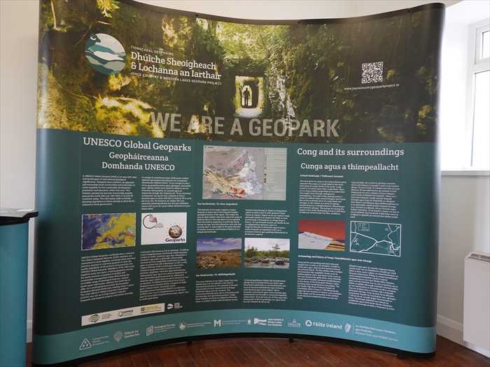
「Joyce Country & Western Lakes Geopark Project
(ジョイス・カントリーと西湖のジオパーク・プロジェクト)」に関する 案内パネル 。
UNESCO Global Geoparks(ユネスコ世界ジオパーク)
・ユネスコ世界ジオパーク(UNESCO Global Geopark, UGGp)**とは、国際的に重要な
地質遺産を持ち、それを教育・保護・持続可能な観光と地域経済に活かす地域です。
・現在世界に177のUGGpがあり、46カ国にまたがっています。
・このプロジェクトは、アイルランド西部(メイヨー県・ゴールウェイ県)のジョイス・
カントリーと西 部湖沼地 域を対象としています。
カントリーと西 部湖沼地 域を対象としています。
Cong and its surroundings(コングとその周辺)
・コングは、火山活動と氷河作用により形成された特異な地形にあります。
・古代から人々がこの土地で暮らし、**Cong Abbey(修道院)や地下水のネットワーク
(The Rising & Sinking Rivers)**などが地形と深く関わっています。
(The Rising & Sinking Rivers)**などが地形と深く関わっています。
・アシュフォード城(Ashford Castle)やラフ・コリブ(Lough Corrib)、ラフ・マスク
(Lough Mask)なども近隣の見どころです。
(Lough Mask)なども近隣の見どころです。
Our Geodiversity
・この地域には、火山岩、堆積岩、変成岩、石灰岩など様々な地質が存在し、地球の形成史を
理解するのに貴重です。
理解するのに貴重です。
・氷河の跡やカルスト地形(溶食地形)も多く、これが湖や洞窟、地下水脈などの形成に
影響しています。
影響しています。
Our Biodiversity
・ジオパーク内では、自然と人間の営みが調和しており、森林、湖、湿原、牧草地などが
生物多様性を支えています。
生物多様性を支えています。
・動植物の保護にも取り組みが進められており、ヨーロッパレベルで重要な種の生息地も
存在します。
存在します。
Archaeology and history of Cong
・コングは古代からの人類の活動の証が豊富に残る地域です。
・有名な修道士聖フィンニアンにより建てられた修道院跡、バイキング時代の痕跡、
アングロ・ノルマン様式の石橋などが見られます。
アングロ・ノルマン様式の石橋などが見られます。
・地元の生活や土地利用の歴史を学ぶ上でも重要な場所です。
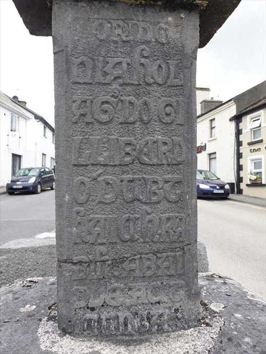
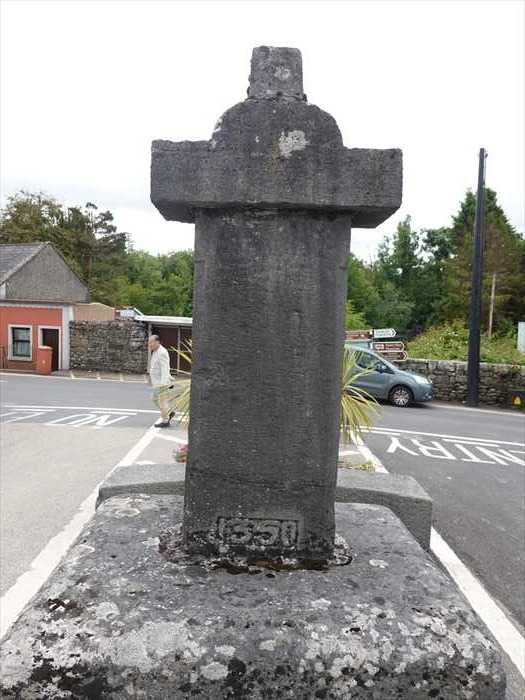
「Toulist Office」を出て 再び「Cong Abbey・コング修道院」の遺跡 を見る 。
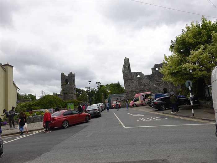
R345の道路の中央にあった「 Cross of Cong 」。
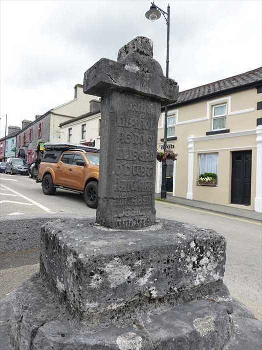
この石碑の碑文は 古いゲール語(アイルランド語)で 刻まれているようであった。
十字架には「 OR DO NIAHOL AG DO GILLIBERD O'DUBTHAIGH RABIH ABAIDDE
AGT CUNGA 」と刻まれており、「コングの修道院長であったニアホルとギルバート・
オドゥブタイのために祈りなさい」という意味であると。
裏面。
そして駐車場に戻ったが、旅友Yさんが、「Cong Abbey」内にガイドブックを忘れて来た
ことが判明した。旅友Yさんが、直ぐにひきかえたが、幸い見つかりやれやれであった。
そしてこの日の最後の訪問場所「Ashford Castle・アッシュフォード城」 への入口に
向かって進むが、いろいろな入口があり、車で入門できる場所に辿り着くのに手間取った
のであった。
そして漸く、「 Ashford Castle Front Gate 」から中に入れたのであった。
・・・ もどる ・・・
・・・ つづく ・・・
「Toulist Office」を出て 再び「Cong Abbey・コング修道院」の遺跡 を見る 。
R345の道路の中央にあった「 Cross of Cong 」。
この石碑の碑文は 古いゲール語(アイルランド語)で 刻まれているようであった。
十字架には「 OR DO NIAHOL AG DO GILLIBERD O'DUBTHAIGH RABIH ABAIDDE
AGT CUNGA 」と刻まれており、「コングの修道院長であったニアホルとギルバート・
オドゥブタイのために祈りなさい」という意味であると。
裏面。
そして駐車場に戻ったが、旅友Yさんが、「Cong Abbey」内にガイドブックを忘れて来た
ことが判明した。旅友Yさんが、直ぐにひきかえたが、幸い見つかりやれやれであった。
そしてこの日の最後の訪問場所「Ashford Castle・アッシュフォード城」 への入口に
向かって進むが、いろいろな入口があり、車で入門できる場所に辿り着くのに手間取った
のであった。
そして漸く、「 Ashford Castle Front Gate 」から中に入れたのであった。
・・・ もどる ・・・
・・・ つづく ・・・
お気に入りの記事を「いいね!」で応援しよう


【毎日開催】
15記事にいいね!で1ポイント
© Rakuten Group, Inc.