Selkirk Copper's Final Phase 1 Drill Program Results Deliver High-Grade Mineralization Intersected Across Five Target Areas, and Rapid Progress on the Phase 2 Drill Program
Highlights
-
Drilling at Area 118has confirmed discovery of the high-grade 301 Lens beneath previous drilling:
-
4.39% Cu, 7.60 g/t Au, and 21.07 g/t Ag (10.22% CuEq) over 4.1 m,within a broader interval of 1.56% Cu, 2.26 g/t Au, and 7.63 g/t Ag (3.31% CuEq) over 15.7 m, from 278.6 m in 26SCM157
-
Within this interval, individual one-meter bornite-rich samples returned grades as high as 4.6% Cu, 23.1 g/t Au, and 26.4 g/t Ag.
-
-
Drilling at Minto Eastcontinues to intersect high-grade mineralization beneath the limits of previous drilling:
-
3.77% Cu, 6.74 g/t Au, and 23.68 g/t Ag (8.99% CuEq) over 3.8 m,within a broader interval of 1.38% Cu, 2.34 g/t Au, and 8.67 g/t Ag (3.20% CuEq) over 11.3 m, from 639.7 m in 26SCM134
-
-
Drilling at the 117 Lensbeneath the Area 2 Pit has intersected broad zones of copper-gold-silver mineralization as well as high grade intervals, including:
-
2.93% Cu, 1.50 g/t Au, and 16.37 g/t Ag (4.19% CuEq) over 5.0 m, from 325.4 m in 26SCM142
-
0.63% Cu, 0.08 g/t Au, and 1.74 g/t Ag (0.70% CuEq) over 47.9 m, from 348.1 m in 26SCM167
-
-
Drilling at Minto Northcontinues to delineate high-grade mineralization in the 202 Lens:
-
3.56% Cu, 2.34 g/t Au, and 21.42 g/t Ag (5.48% CuEq) over 3.7 m,within a broader interval of 0.89% Cu, 0.49 g/t Au, and 4.84 g/t Ag (1.29% CuEq) over 21.7 m, from 195 m in 26SCM131
-
-
Drilling at Ridgetopcontinues to intersect broad intervals of near-surface mineralization:
-
0.46% Cu, 0.14 g/t Au, and 1.57 g/t Ag (0.58% CuEq) over 69.6 m, from 13.7 m in 26SCM137
-
-
The 50,000 metre Phase 2 drill program is advancing rapidly, with 14,000 metres completed during the first month of drilling. Drilling productivity is averaging 120 metres per day per drill, with four drills active currently. This program is focused on resource expansion, infill drilling, geotechnical drilling, and geometallurgical data collection.
Vancouver, British Columbia and Pelly Crossing, Yukon--(Newsfile Corp. - June 3, 2026) - Selkirk Copper Mines Inc. (TSXV: SCMI) (FSE: IO20) (OTCQB: SKRKF)(" Selkirk Copper" or the " Company") is pleased to announce final results from the Phase 1 drill program which was conducted between August 2025 and April 2026, as well as rapid progress on the Phase 2 drill program which was initiated in May 2026, at the Minto Project in Yukon, Canada.
M. Colin Joudrie, President & CEO, commented: "The Phase 1 drill program has achieved exceptional results at each of the five primary target areas within the mine footprint – expanding known zones of mineralization, discovering several higher grade copper-gold-silver intervals within known zones, discovering several new lenses of high grade mineralization, and discovering mineralization at depths previously undrilled. The team successfully completed the largest drill program in the Yukon over the last ten years and did so safely, on-budget, and on-schedule through one of the coldest falls and winters on record. These results are being incorporated into an updated Mineral Resource Estimate and Preliminary Economic Assessment that remains on track for completion in mid-2026.
"We could not have asked for a better start to the 50,000 meter Phase 2 drill program with drill productivity exceeding already high performance from the Phase 1 drill program. The Phase 2 program is designed to inform a planned feasibility study in-fill drilling, resource definition, integrated mine planning, economic studies, and refinements to the restart development opportunity. The Phase 1 program has proven that there is still significant discovery potential in the near-mine environment, and supports our view that our commitment to the Phase 2 program, along with the first significant district and regional exploration in over a generation to be carried out this summer, will continue to deliver meaningful positive results for the Minto Project".
2025-2026 Phase 1 Drill Program Results
Reported here is the final batch of results from the Phase 1 drill program that was completed earlier this year. This includes assay results from forty-six (46) holes drilled between February and March 2026.
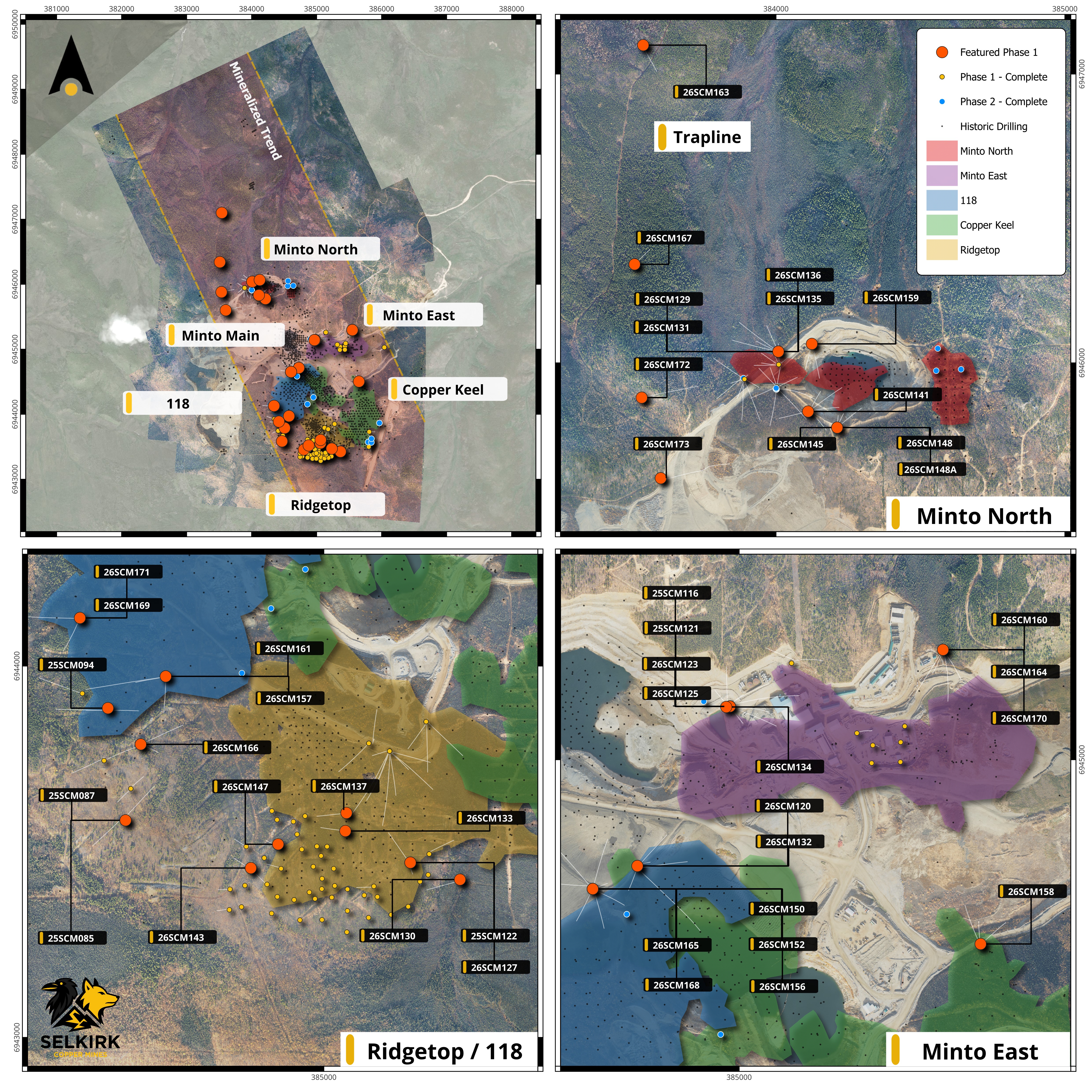
Figure 1 : Plan view of the Minto Mine Property area showing surface projections of mineralized zones relative to Phase 1 and Phase 2 drill collars.
To view an enhanced version of this graphic, please visit:
https://images.newsfilecorp.com/files/11605/299936_figureone.jpg
Area 118 and the 301 Lens
Area 118 hosts near-surface resources on a hillside that is located south of previous open pit mining. This area became a priority for exploration due to recognition of anomalous drill intercepts that had not been adequately followed-up beneath the known near-surface resources. Recognition of the additional potential at this target resulted from geological modelling and detailed data review completed by Selkirk Copper during early 2026. Reported here are eight holes from Area 118, seven of which intersected significant mineralization.
The drilling completed at Area 118 has confirmed discovery of a high-grade mineralized lens at depth beneath the previously known resources in this area. This new discovery of mineralization at depth has been designated the 301 Lens. The 301 Lens is located between 100 and 140 metres below previously known resources in this area potentially repeating a pattern of stacked lenses of mineralization intersected elsewhere on the mine property. This lens has been intersected by widely spaced drill holes over an area approximately 500 x 300 metres, with thicknesses ranging from 4 to 20 metres thick.
Mineralization within this area is characterized by bornite and chalcopyrite mineralization hosted within foliated and migmatized granodiorite. Bornite mineralization is associated with higher copper and gold grades, and thicker mineralized intervals. Locally, bornite mineralization occurs in coarse blebs up to 3 cm wide comprising up to 5% of the volume of the rock. These intervals can host high grades, such as the intercept from drill hole 26SCM157 which returned 1.56% Cu, 2.26 g/t Au, and 7.63 g/t Ag (3.31% CuEq) over 15.7 m. Within this interval, individual one-meter bornite-rich samples returned grades as high as 4.6% Cu, 23.1 g/t Au, and 26.4 g/t Ag. These gold and silver grades rank amongst the highest precious metal concentrations observed within all previous drilling at Minto, within a database of 163,000 historical samples.
The discovery of additional mineralization in Area 118 and the 301 Lens represents an important opportunity for resource expansion. New drill intercepts are located within 300 meters of previous underground development, providing an opportunity for future mining at relatively low cost. Additional drilling of this area is planned as part of the Phase 2 drill program.
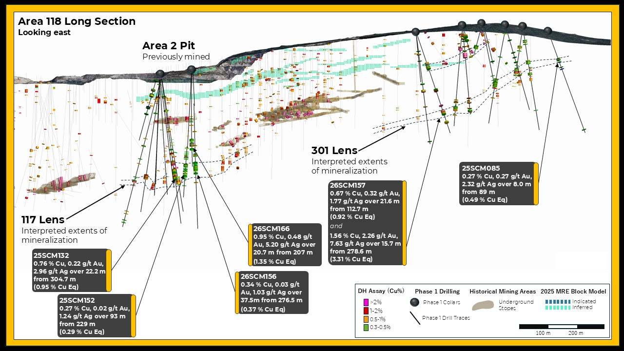
Figure 2 : Cross section view looking east showing recently discovered mineralization within the 301 Lens and 117 Lens, located in proximity to areas of previous underground mining.
To view an enhanced version of this graphic, please visit:
https://images.newsfilecorp.com/files/11605/299936_figuretwo.jpg
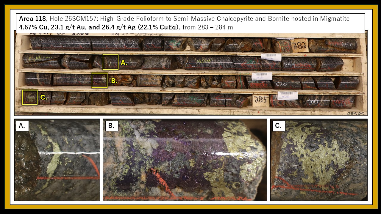
Figure 3 : Detail photographs showing high-grade mineralization from the 301 Lens within Area 118.
To view an enhanced version of this graphic, please visit:
https://images.newsfilecorp.com/files/11605/299936_figurethree.jpg
117 Lens
In central part of the Mine area, recent drilling has delineated mineralization underground in an area between two historical open pits, the Minto Main Pit and the Area 2 Pit. The discovery of mineralization at depth in this area has been designated the 117 Lens. Reported here are eight holes from the Minto Main area, all of which intersected significant mineralization.
Mineralization within this area includes broad intervals of chalcopyrite mineralization, ranging from 20 – 90 metres thick with weighted average grades ranging from 0.3 – 0.7% copper. Narrower zones of higher-grade mineralization also occur within this area, such as in hole 26SCM142 which intersected 2.93% Cu, 1.50 g/t Au, and 16.37 g/t Ag (4.19% CuEq) over 5.0 m. Initial drilling of the 117 Lens is still relatively widely spaced, and more work is planned to understand the controls on high grade mineralization within the broader mineralized domain.
Mineralization in the 117 Lens has been delineated over an area approximately 300 by 250 metres and remains open to the west. Also reported here is 26SCM168, one of the last holes of the Phase 1 drill program and a 150-metre step-out westwards from previous drilling in this area. This hole intersected 47.9 m grading 0.63% Cu, 0.08 g/t Au, and 1.74 g/t Ag (0.70% CuEq) and indicates potential for further expansion of the 117 Lens. Additional drilling of this area is planned as part of the Phase 2 drill program.
Minto East
Drilling at Minto East targeted expansion of several stacked mineralized lenses, with a focus of expansion northwards and southwards from previously known resources. Reported here are eight holes from the Minto East area, five of which intersected significant mineralization. Three holes failed to intersect mineralization on the eastern and western edges of the Minto East zone, however mineralization remains open in some areas to the north and to the south.
Hole 26SCM125 represents a relatively typical example of mineralization at Minto East, with three significant mineralized intercepts spaced approximately 100 m apart, including 1.4 m grading 11.23% CuEq at 211 m, 2.7m grading 5.41% CuEq at 336 m, and 4.8m grading 1.51% CuEq at 438 m (detailed assays in Table 2). The lower-most of these significant intercepts is located within 50 metres of historical underground workings, at the same elevation, providing an opportunity for future extraction at relatively low cost.
Also reported from Minto East is hole 26SCM134 which intersected 3.77% Cu, 6.74 g/t Au, and 23.68 g/t Ag (8.99% CuEq) over 3.8 m, within a broader interval of 1.38% Cu, 2.34 g/t Au, and 8.67 g/t Ag (3.20% CuEq) over 11.3 m, from 639.7 m. Mineralization within this interval is characterized by folioform chalcopyrite and blebby disseminated bornite hosted within migmatized granodiorite. This hole represents the deepest intercept of high-grade mineralization that has ever been drilled at Minto; most previous drilling was limited to less than 500 metres below surface, and no comparable high-grade mineralization has previously been intersected beyond 550 metres below surface. Additional drilling is contemplated for this area once the underground workings are accessible.
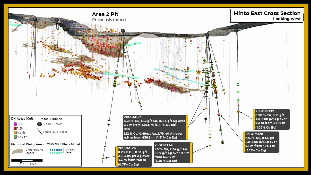
Figure 4: Cross section view looking west highlighting drill holes from the Phase 1 program that intersected mineralization at depth beneath previous underground mining areas.
To view an enhanced version of this graphic, please visit:
https://images.newsfilecorp.com/files/11605/299936_figurefour.jpg
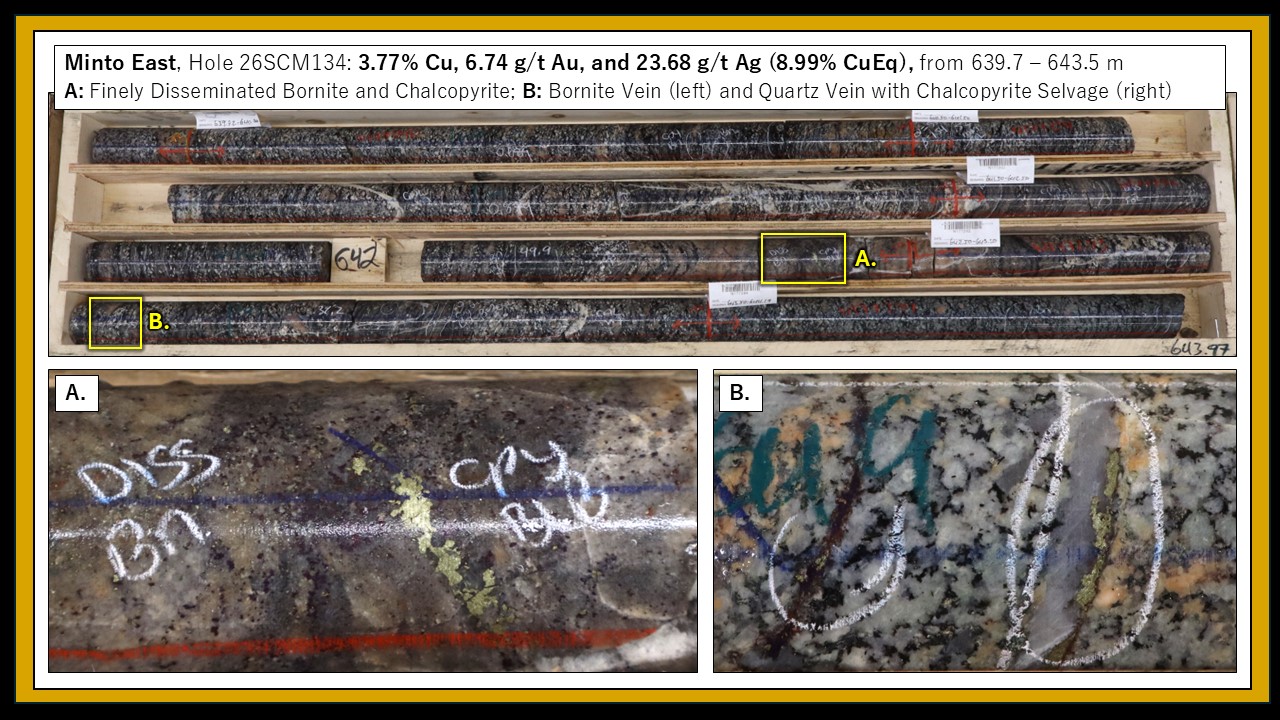
Figure 5 : Detail photographs showing high-grade mineralization intersected at depth within Minto East.
To view an enhanced version of this graphic, please visit:
https://images.newsfilecorp.com/files/11605/299936_figurefive.jpg
Ridgetop
Drilling at Ridgetop was a significant focus throughout the Phase 1 drill program. This drilling targeted shallow mineralization that can potentially be mined via an open pit at a lower cut-off grade. Reported here are six holes from Ridgetop, five of which intersected significant mineralization.
Mineralization at Ridgetop is typically characterized by a series of closely spaced, sub-parallel mineralized lenses that are typically 5 – 15 metres thick. In some areas, multiple mineralized lenses occur in proximity and result in thicker mineralized intervals. Drill hole 26SCM137 represents an example of this thicker, more continuous mineralization with an intersection of 0.46% Cu, 0.14 g/t Au, and 1.57 g/t Ag (0.58% CuEq) over 69.6 m, from 13.7 m. This mineralization begins at the top of bedrock beneath a thin veneer of overburden and represents a potential opportunity for extraction early in the mine life with minimal waste stripping.
Minto North
Drilling at Minto North was a major focus throughout the Phase 1 drill program, including focus on the expansion and delineation of the Minto North west zone. Reported here are results from eight holes from Minto North, four of which intersected significant mineralization.
The Minto North west zone returned some of the highest grade and highest thickness drill intercepts during the Phase 1 drill program. Mineralization occurs within a lens-shaped area that is approximately 300 x 400 m, and up to 30 m thick. High-grade copper, gold, and silver grades are associated with blebby, folioform, net-textured, and semi-massive bornite and chalcopyrite mineralization. This area has been designated as the 202 Lens for purposes of geological modelling and resource estimation and is notably higher-grade than other parts of Minto North.
Drill results reported here targeted the periphery of the 202 Lens and are generally lower grade than some results from this zone that were reported earlier during the Phase 1 drill program. Drill hole 26SCM131 is a notable exception and represents the high tenor of mineralization that occurs within the central portion of the 202 Lens. This hole intercepted 5.48% CuEq over 3.7 m, within a broader interval of 1.29% CuEq over 21.7 m, from 195 m (detailed assays in Table 2). Other holes reported here intersected thinner and lower grade intervals around the periphery of the 202 Lens. Four holes tested beyond the limits of the mineralized lens and failed to intersect significant mineralization; however, these holes do provide important information to constrain resource estimation and mine planning.
Drilling in Other Areas
Reported here also is one drill hole from the Copper Keel area and two drill holes from an Exploration target called Trapline.
At Copper Keel, drill hole 26SCM158 was a 50-metre step out northwards from resources that were previously delineated in this area. This hole returned an intersection of 0.53% Cu, 0.29 g/t Au, 2.18 g/t Ag (0.77% CuEq) over 9.9 metres. Other step-out drilling in this area failed to intersect significant mineralization. Results from drilling in this area suggest that further resource expansion potential at the north end of Copper Keel is limited.
Trapline is a new name proposed for the northern half of the Minto claim block. This area is considered prospective for continuation of the mineralized trends observed within the Minto Project area. The Trapline area includes numerous geophysical and geochemical targets resulting from work by previous operators. During the 2025-2026 drill program, two drill holes totaling 750 metres were completed to test geophysical anomalies in the Trapline area.
The first hole, 26SCM163, targeted an area containing several coincident geophysical anomalies, characterized by a conductive magneto-telluric (MT) response, a magnetic high response, and a moderate chargeability response. This area also contained weakly anomalous copper in soil values. This drillhole intersected foliated granodiorite, assimilation textures, and a narrow 4 m interval containing folioform chalcopyrite. Assay results were sub-economic and the drill hole is considered a "near-miss" that may warrant follow-up.
The second hole, 26SCM167, targeted a northwest-trending magnetic high associated with a moderate chargeability feature at depth. This drill hole intersected foliated granodiorite and assimilation textures but did not intersect any sulphide mineralization. There were no obvious lithological features observed in this hole to explain the geophysical anomalies in this area.
The results of this exploration drilling at Trapline demonstrate that further evaluation of geological and geophysical datasets is needed to guide exploration drilling in this area. Physical property samples and lithogeochemical samples were collected from these drill holes, and the results of these analyses may help inform future exploration. Additional geophysical surveys, geological mapping, and geochemical sampling will also help with identifying future exploration targets within the northern half of the Minto claim block.
Table 1: Collar Locations and Header Information
| Hole ID |
Easting |
Northing |
Azi |
Dip |
EOH (m) |
Zones |
|---|---|---|---|---|---|---|
| 25SCM085 |
384466 |
6943599 |
225 |
-68 |
324 |
Area 118 |
| 25SCM087 |
384468 |
6943596 |
45 |
-70 |
339 |
Area 118 |
| 25SCM094 |
384423 |
6943880 |
270 |
-50 |
225 |
Area 118 |
| 25SCM116 |
384972 |
6945144 |
45 |
-80 |
346.48 |
Minto East |
| 25SCM121 |
384973 |
6945141 |
135 |
-80 |
312 |
Minto East |
| 25SCM122 |
385231 |
6943469 |
323.1 |
-64.3 |
231 |
Ridgetop |
| 26SCM120 |
384731 |
6944717 |
60 |
-85 |
456 |
Minto Main |
| 26SCM123 |
384969 |
6945146 |
315 |
-80 |
363 |
Minto East |
| 26SCM125 |
384968 |
6945143 |
100 |
-73 |
525 |
Minto East |
| 26SCM127 |
385228 |
6943470 |
160 |
-80 |
180 |
Ridgetop |
| 26SCM129 |
384003 |
6946041 |
281 |
-52 |
264 |
Minto North |
| 26SCM130 |
385371 |
6943423 |
250 |
-70 |
282 |
Ridgetop |
| 26SCM131 |
384004 |
6946041 |
290 |
-70 |
240 |
Minto North |
| 26SCM132 |
384726 |
6944709 |
206 |
-80 |
408 |
Minto Main |
| 26SCM133 |
385061 |
6943556 |
275 |
-75 |
270 |
Ridgetop |
| 26SCM134 |
384965 |
6945139 |
84 |
-80 |
715.35 |
Minto East |
| 26SCM135 |
384004 |
6946042 |
305 |
-51 |
264 |
Minto North |
| 26SCM136 |
384008 |
6946040 |
335 |
-66 |
246 |
Minto North |
| 26SCM137 |
385062 |
6943604 |
265 |
-68 |
210 |
Ridgetop |
| 26SCM141 |
384116 |
6945834 |
80 |
-70 |
306 |
Minto North |
| 26SCM143 |
384804 |
6943453 |
302 |
-74.9 |
213 |
RT South |
| 26SCM145 |
384212 |
6945776 |
20 |
-80 |
300 |
Minto North |
| 26SCM147 |
384878 |
6943513 |
300 |
-80 |
228 |
RT South |
| 26SCM148 |
384212 |
6945776 |
4.6 |
-62 |
90 |
Minto North |
| 26SCM148A |
384212 |
6945776 |
49 |
-62 |
228 |
Minto North |
| 26SCM149 |
384606 |
6944654 |
15 |
-72 |
465 |
Minto Main |
| 26SCM150 |
384604 |
6944654 |
322 |
-66 |
501 |
Minto Main |
| 26SCM152 |
384605 |
6944652 |
73 |
-83 |
372 |
Minto Main |
| 26SCM156 |
384605 |
6944652 |
120 |
-76 |
477 |
Minto Main |
| 26SCM157 |
384574 |
6943971 |
260 |
-55 |
384 |
Area 118 |
| 26SCM158 |
385649 |
6944502 |
354 |
-83 |
489 |
Copper Keel |
| 26SCM159 |
384123 |
6946070 |
164 |
-65 |
299 |
Minto North |
| 26SCM160 |
385550 |
6945297 |
167 |
-75 |
537.68 |
Minto East |
| 26SCM161 |
384574 |
6943971 |
180 |
-70 |
282 |
Area 118 |
| 26SCM162 |
384608 |
6944655 |
165 |
-75 |
474 |
Minto Main |
| 26SCM163 |
383537 |
6947099 |
150 |
-75 |
411 |
Trapline |
| 26SCM164 |
385548 |
6945295 |
137 |
-78 |
546 |
Minto East |
| 26SCM165 |
384607 |
6944656 |
210 |
-75 |
381 |
Minto Main |
| 26SCM166 |
384507 |
6943789 |
110 |
-80 |
288 |
Area 118 |
| 26SCM167 |
383510 |
6946342 |
50 |
-77 |
339 |
Trapline |
| 26SCM168 |
384604 |
6944660 |
273 |
-68 |
432 |
Minto Main |
| 26SCM169 |
384345 |
6944127 |
210 |
-60 |
267 |
Area 118 |
| 26SCM170 |
385548 |
6945296 |
189 |
-82 |
522 |
Minto East |
| 26SCM171 |
384343 |
6944128 |
270 |
-60 |
348 |
118 |
| 26SCM172 |
383535 |
6945880 |
86 |
-65 |
480 |
Minto North |
| 26SCM173 |
383590 |
6945590 |
75 |
-60 |
525 |
Minto North |
Table 2: Significant Interval Table
Hole ID
From
To
Length (m)
Cu %
Au g/t
Ag g/t
CuEq %
Zone
25SCM085
89.0
97.0
8.0
0.27
0.27
2.32
0.49
Area 118
25SCM087
93.0
103.4
10.4
0.43
0.25
2.89
0.64
Area 118
and
120.2
131.0
10.8
0.45
0.15
1.86
0.58
Area 118
25SCM094
No significant intercept
Area 118
25SCM116
259.0
313.0
54.0
0.36
0.08
1.82
0.44
Minto East
Incl.
259.0
266.2
7.2
0.85
0.16
2.16
0.99
Minto East
26SCM121
No significant intercept
Minto East
26SCM123
No significant intercept
Minto East
26SCM125
211.4
212.8
1.4
6.51
5.82
55.69
11.32
Minto East
and
336.5
339.2
2.7
4.28
1.32
16.94
5.41
Minto East
and
438.3
443.1
4.8
1.12
0.49
2.79
1.51
Minto East
26SCM127
58.3
65.5
7.2
0.71
0.28
2.05
0.94
RT South
26SCM129
204.5
217.6
13.1
0.48
0.12
1.98
0.59
Minto North
26SCM130
No significant intercept
RT South
26SCM131
195.0
216.7
21.7
0.89
0.49
4.84
1.29
Minto North
Incl.
213.0
216.7
3.7
3.56
2.34
21.42
5.48
Minto North
26SCM132
276.4
281.1
4.7
2.43
0.79
6.02
3.07
Minto Main
and
304.8
327.0
22.2
0.76
0.22
2.96
0.95
Minto Main
26SCM133
23.8
30.9
7.1
0.62
0.10
1.80
0.71
Ridgetop
and
69.0
79.0
10.0
1.02
0.39
3.35
1.34
Ridgetop
26SCM134
639.7
651.0
11.3
1.38
2.34
8.67
3.20
Minto East
Incl.
639.7
643.5
3.8
3.77
6.74
23.68
8.99
Minto East
26SCM135
No significant intercept
Minto North
26SCM136
216.0
241.0
25.0
0.28
0.09
1.47
0.35
Minto North
26SCM137
13.7
83.3
69.6
0.46
0.14
1.57
0.58
Ridgetop
Incl.
63.4
83.3
19.9
0.84
0.34
3.04
1.13
Ridgetop
26SCM143
56.5
75.3
18.8
0.27
0.09
1.63
0.34
RT South
26SCM145
249.3
255.8
6.5
0.47
0.13
1.95
0.59
Minto North
26SCM147
67.0
82.0
15.0
0.52
0.23
4.00
0.73
RT South
26SCM148A
No significant intercept
Minto North
26SCM149
283.0
355.0
72.0
0.27
0.05
0.94
0.32
Minto Main
Incl.
350.2
355.0
4.8
1.07
0.44
5.30
1.45
Minto Main
26SCM150
263.5
274.2
10.7
0.71
0.23
1.24
0.89
Minto Main
26SCM152
179.0
182.8
3.8
0.36
12.29
6.76
9.56
Minto Main
and
229.0
322.0
93.0
0.27
0.02
1.15
0.29
Minto Main
26SCM156
276.5
314.0
37.5
0.34
0.03
1.03
0.37
Minto Main
26SCM157
112.8
134.4
21.6
0.67
0.32
1.77
0.92
Area 118
Incl.
115.4
121.3
5.9
1.40
0.85
4.04
2.07
Area 118
and
278.6
294.3
15.7
1.56
2.26
7.63
3.31
Area 118
Incl.
281.9
286.0
4.1
4.39
7.60
21.07
10.22
Area 118
26SCM158
402.3
412.2
9.9
0.53
0.29
2.18
0.77
Copper Keel
26SCM159
224.0
254.0
30.0
0.33
0.09
1.45
0.40
Minto North
26SCM160
451.7
469
17.3
0.71
0.48
3.29
1.09
Minto East
26SCM161
216.0
235.8
19.8
1.17
0.63
5.72
1.69
Area 118
Incl.
225.0
230.0
5.0
2.12
0.89
9.49
2.87
Area 118
26SCM162
280.0
307.7
27.7
0.46
0.05
1.48
0.51
Minto Main
26SCM163
No significant intercept
Trapline
26SCM164
450.4
480.1
29.7
0.67
0.38
2.50
0.97
Minto East
Incl.
474.7
477.7
3.0
2.38
0.99
10.83
3.21
Minto East
26SCM165
275.4
295.0
19.6
0.72
0.12
2.85
0.83
Minto Main
26SCM166
207.0
227.7
20.7
0.95
0.48
5.20
1.35
Area 118
Incl.
219.0
223.0
4.0
2.50
1.56
16.49
3.81
Area 118
26SCM167
No significant intercept
Trapline
26SCM168
348.1
396.0
47.9
0.63
0.08
1.74
0.70
Minto Main
26SCM169
208.8
212.5
3.8
1.39
0.49
4.90
1.80
Area 118
26SCM170
No significant intercept
Minto East
26SCM171
31.0
38.4
7.4
0.64
0.14
2.03
0.77
Area 118
26SCM172
No significant intercept
Minto North
26SCM173
No significant intercept
Minto North
At the Minto North and Minto East zones, the flat laying to shallowly dipping nature of the mineralized zones suggest that true widths are typically >90% of the reported drill intersection length. At Ridgetop, RT South, Copper Keel, and Area 118, true widths are estimated to be 85-90% of reported drill intersection.
CuEq Calculation:
CuEq = ((Cu% × CuP × RCu × 2204.62)+(Au g/t ÷ 31.1035 × AuP × RAu) + (Ag g/t ÷ 31.1035 × AgP × RAg ))/(CuP × RCu × 2204.62)
Where:
CuP/AuP/AgP = US$ commodity prices of $4.25/lb Cu, $2500/oz Au, $29/oz Ag; RCu = Cu Recovery = 98%; RAu = Au Recovery = 85%; RAg= Ag Recovery = 85%
Recoveries as estimated from historical mineral processing results.
2026 Phase 2 Drill Program
Four drill rigs are active on the Phase 2 drill program, which commenced on May 1, 2026. This drill program is targeting approximately 50,000 metres with a focus on resource expansion, infill drilling, geotechnical drilling, and geometallurgical data collection to support increased resource confidence and mine planning for planned feasibility study work.
Drilling productivity has been significantly higher than expected throughout the first month of the Phase 2 drill program. Daily drill productivity is currently averaging 120 metres per day, compared to 94 metres per day during the Phase 1 program. The team on site is ramping up to handle the increased productivity, with hiring and training of new staff, and obtaining additional equipment and supplies.
As of June 1, 14,000 metres of drilling has been completed in 59 holes, comprising 28% of the planned 50,000 metres. Drilling has focused on resource expansion and infill at several locations within the deposit area, including Minto North, Copper Keel, Minto Main (117 Lens) and Area 118 (301 Lens). The first batches of samples have been shipped off site for laboratory analysis, and initial assay results are expected within eight weeks. Results from the Phase 2 program are expected to be released throughout the summer and fall of 2026.
Marketing Services
Further to the Company's news release dated December 1, 2025 and subject to the approval of the TSX Venture Exchange, the Company has renewed its marketing services agreement with Triomphe Holdings Ltd., doing business as Capital Analytica ("Capital Analytica"), for an additional six-month term at a cost of $75,000, which was paid on May 27, 2026. Capital Analytica is an arm's-length service provider, and will continue to provide certain marketing and social media services to the company, in accordance with the policies of the TSX Venture Exchange and applicable securities laws. Based in Nanaimo, B.C., Capital Analytica specializes in marketing, social media and public awareness within the mining and metals sector. Capital Analytica will provide social media services, capital market consultation and social engagement reporting until November 27, 2026, being the end of the additional six-month term, unless terminated earlier in accordance with the terms of the agreement. Capital Analytica has no direct or indirect interest in the company or its securities, and has no current intention or right to acquire any such interest during the engagement.
Further to the Company's news release dated January 22, 2026 and subject to the approval of the TSX Venture Exchange, the Company has amended its digital advertising agreement with Native Ads Inc. ("Native Ads"), pursuant to which the Company has agreed to pay an additional aggregate amount of US$250,000, payable in installments of US$65,000 on June 3, 2026, US$65,000 on June 15, 2026, US$60,000 on July 5, 2026 and US$60,000 on August 5, 2026, to replenish the budget under the agreement to continue advertising and investor awareness services. The Company wishes to clarify that the reference to a six-month term for the Native Ads engagement in its January 22, 2026 news release was incorrect. The Native Ads agreement commenced on January 22, 2026 and has a 24-month term ending on January 21, 2028, unless terminated earlier in accordance with its terms. The agreement includes references to budget exhaustion which relate to the deployment of the budget for advertising and investor awareness services, and do not modify the 24-month contractual term of the engagement. Native Ads is led by Jon Malach and is an arms-length Delaware Corp. with a registered office located in New York. Native Ads has no direct or indirect interest in the company or its securities, and has no current intention or right to acquire any such interest during the engagement.
QAQC Procedures and Data Validation
The Company is drilling NQ sized core. Following data collection, core is cut along the long axis, with half of the core going to the lab for chemical analysis and the remaining half kept in sequence as record. The half core samples are packaged with the corresponding sample tag id and sealed. All sampling is conducted by Selkirk Copper Mines Inc. and subject to Company standard internal quality control and quality assurance (QAQC) programs which include the insertion of certified reference material, coarse blank materials, and field duplicate analysis, on top of the standard laboratory QAQC procedures to monitor contamination during preparation and analytical accuracy and precision. QAQC insertion rates approximate 15% of all samples at set intervals. For the 2025 program all samples were sent to ALS Laboratory's prep laboratory in Whitehorse, YK, then shipped to ALS Vancouver for gold fire assay and four-acid multi-element analysis. All samples are prepared by crushing rock to 70% passing 2mm screen, then splitting a 250g sub-sample using a riffle splitter before being pulverized 85% passing 75 microns. Gold is analyzed by 30 g Fire Assay (Au-AA23) with atomic absorption (AAS) analysis followed by gravimetric finish for overlimit results. Copper is analyzed by four-acid digest (ME-ICP61) with inductivity coupled plasma – atomic emission spectroscopy (ICP-AES) finish. If copper overlimit results are triggered a second four-acid digest for high grade copper (Cu-OG62) is conducted. Samples containing greater than 1000 ppm copper are also analyzed for soluble copper using a sulphuric acid leach (Cu-AA05) analysis with AAS finish is performed. ALS Vancouver holds an ISO/IEC 17025 standard accreditation.
QAQC results are reviewed open receipt of results. Overall QAQC results show strong analytical performance across Cu, Au, and Ag datasets. All control standards are within acceptable tolerance, with no significant outliers or systematic bias observed.
Primary intervals are reported as drill core length, with true widths estimated to be approximately 90% of core lengths, based on the sub-horizontal to shallow-dipping nature of the modelled mineralized zones.
Mineral Resource Estimate Details
The following table summarizes the current Minto Mineral Resource Estimate:
Table 3: Global Mineral Resource Estimate for the Minto Project (Effective Date: April 7, 2025)
Type
Cut
Class
ROM
In Situ Grade
Metal
(CDN$)
Tonnage (000)
NSR (CDN$)
Cu (%)
Au (gpt)
Ag (gpt)
Ox Ratio
ASCu (%)
Cu (Mlbs)
Au (Koz)
Ag (Koz)
OP
$30
Indicated
6,085
$89.11
0.897
0.274
2.9
0.15
0.163
120.3
53.7
560.4
Inferred
9,496
$73.71
0.702
0.162
2.4
0.07
0.057
146.9
49.3
738.4
UG
$80
Indicated
6,504
$183.90
1.489
0.636
5.6
0.06
0.090
213.5
132.9
1,167.6
Inferred
14,162
$156.85
1.281
0.539
4.9
0.06
0.075
399.9
245.4
2,229.6
Total
Varies as Above
Indicated
12,588
$138.08
1.203
0.461
4.3
0.10
0.125
333.8
186.6
1,728.0
Inferred
23,658
$123.48
1.048
0.387
3.9
0.07
0.068
546.8
294.7
2,968.1
Notes
References
1 See 2025-08-06 Technical Report " NI 43-101 2025 Mineral Resource Estimate Update for the Minto Property, Yukon, Canada " effective date 2025-04-07 filed by Venerable Ventures Ltd., available on SEDAR+ (sedarplus.ca).
Technical aspects of this news release have been reviewed, verified and approved by Leif Bailey, P.Geo., Director of Geoscience & Exploration of Selkirk Copper Mines Inc., who is a qualified person as defined by National Instrument 43-101 – Standards of Disclosure for Mineral Projects.
About Selkirk First Nation
Selkirk First Nation is centered in Pelly Crossing, a community in central Yukon, 280 km north of Whitehorse. They are a self-governing First Nation, having signed its Final and Self-Government Agreements in 1997. Selkirk First Nation owns 4,740 square kilometers of Settlement Land, including 2,408 square kilometers where they own both the surface and subsurface. Selkirk First Nation is one of three self-governing Northern Tutchone First Nations in the Yukon. The Selkirk First Nation, indirectly, holds a controlling equity stake in Selkirk Copper.
About Selkirk Copper
Selkirk Copper is a well-financed, newly formed company with a controlling interest held by the Selkirk First Nation through its wholly owned subsidiary, that, in partnership with the Selkirk First Nation, is completing a thorough exploration drilling campaign and a restart and redevelopment plan for the former Minto copper-gold-silver mine based on best-in-class environmentally sustainable mining, development and reclamation practice. Selkirk Copper controls 26,850 hectares of prospective mineral claims located in the Minto-Carmacks copper belt as well as significant open-pit and underground infrastructure, a 4,100 tonne per day processing plant, 400-person full-rotation camp, water treatment facilities, numerous ancillary buildings, and mobile equipment centered on the former Minto copper-gold-silver mine. Selkirk Copper's mineral tenure, operation infrastructure, access roads and powerline, is located on or adjacent to Lands of the Selkirk First Nation much of which is surrounded by prospective Selkirk First Nation Category A Lands.
Selkirk Copper Mines Inc. is listed on the TSX Venture Exchange under the symbol (TSXV: SCMI), has a secondary listing on the Frankfurt Exchange under the symbol (FSE: IO20), and its common shares trade under the symbol (OTCQB: SKRKF)on the OTCQB® Venture Market, a U.S. marketplace operated by OTC Markets Group Inc.
On behalf of the Board of Directors of Selkirk Copper Mines Inc.
M. Colin Joudrie
President and Chief Executive Officer
For more information, please contact:
M. Colin Joudrie, President & CEO
colin.joudrie@selkirkcopper.com
(604) 760-3157
Justin Stevens, Vice-President Corporate Development
justin.stevens@selkirkcopper.com
(604) 240-2959
Neither the TSX Venture Exchange nor its Regulation Services Provider (as that term is defined in the policies of the TSX Venture Exchange) accepts responsibility for the adequacy or accuracy of this release.
CAUTIONARY STATEMENT REGARDING FORWARD-LOOKING INFORMATION
Except for the statements of historical fact, this news release contains "forward-looking information" within the meaning of applicable Canadian securities legislation. When used in this news release, the words "estimate", "project", "belief", "anticipate", "intend", "expect", "plan", "predict", "may" or "should" and the negative of these words, or variations thereon or comparable terminology are intended to identify forward-looking statements and information. The forward-looking statements and information in this news release include information relating to: the remainder of the Company's drill program and integrating results into ongoing trade-off studies, the business plans and objectives of the Company, and future planned drilling and feasibility study work. Such forward-looking information is based on the Company's expectations, estimates and projections as at the date of this news release.
By their nature, forward-looking statement involve known and unknown risks, uncertainties and other factors, which may cause actual result, performance or achievements to differ materially from those expressed or implied by such statements, including but not limited to: the potential inability of the Company to continue as a going concern, risks associated with potential governmental and/or regulatory action with respect to the Company's operations, the potential inability of the Company to implement its business plan going forward. Such statements and information reflect the current view of the Company and are based on information currently available to the Company. In connection with the forward-looking information contained in this news release, the Company has made assumptions about the Company's ability to execute on its business plans. The Company has also assumed that no significant events will occur outside the Company's normal course of business. Although the Company believes that the assumptions inherent in the forward-looking information are reasonable, forward-looking information is not a guarantee of future performance and accordingly undue reliance should not be put on such information due to the inherent uncertainty therein.
Any forward-looking information speaks only as of the date on which it is made and, except as may be required by applicable securities laws, the Company disclaims any intent or obligation to update any forward-looking information, whether as a result of new information, future events or results or otherwise.
To view the source version of this press release, please visit https://www.newsfilecorp.com/release/299936