[恵那峡] カテゴリの記事
全8件 (8件中 1-8件目)
1
-
恵那峡の絶景を行く
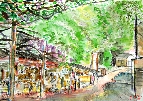
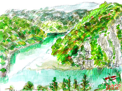
恵那峡(その2)_story(1989) 2010.5.19中津川はいま新緑がまぶしい。今日は雨。しかし、部屋から雨の音が聞こえない。日差しもある。runningスタイルになって颯爽と走ろうとした。なんと、外にでてみるとそぼふる雨である。新緑に余りにも静かに降る雨。止んだかと又走りだそうとするもまだ雨。往生際が悪い!早く走りたい! 明日は晴れるという。さて、学生を歩かせた後、急いでスケッチをしている。肝心の藤棚を描かなければ!学生が帰ってくる音が・・。恵那峡さざなみ公園・・土産屋と藤棚 初夏の藤棚 という面持ちの風景。眩しい場所もあり、ひさしのほろを下げ始めていた。畳み200畳くらいの広がりをもつ藤棚。花の最盛期は終わっているものの、端っこにはまだいくつかの房が残っている。すでに緑陰となり、奥の方(絵では手前)の土産屋は涼しげだ。学生が談笑しながら戻ってきてしまった。2枚の絵を学生にも見せる。絵は(スケッチ方向140° pm3:40 Google Earth 地名=恵那 スケッチpoint:GPS 35.480636,137.406572(単位は°)(北緯、東経表示では、35°28'50.29" N,137°24'23.66" E))
May 19, 2010
コメント(0)
-
絶景 恵那峡の湖畔
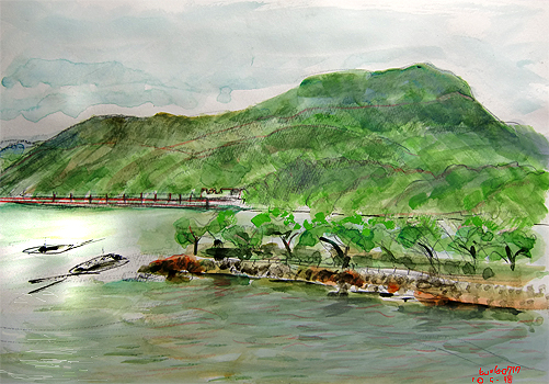
恵那峡(その1)_story(1988) 2010.5.18中津川はいま新緑がまぶしい。東京と違って緑一色であるため誠に美しい。4年生のゼミの時間、あまりにも天気がよいので、地域学習の一環として、恵那峡に連れ出した。コンピュータ室で卒論の構想を練るのもよいが、春風香る恵那峡でも構想は練れる筈である。そもそも突然女子学生は一眼レフのカメラを買ったと言って時間前に訪ねてきたのがきっかけである。カメラの練習もかねて、じゃあ景色を撮ろうということになり、かねてから狙っていた「恵那峡遊覧船乗り場の上の売店に広がる大きな藤棚が満開を迎えた頃行って見たい」とこの10年思い描いていてすべてチャンスを逸してきたことも”行かなければならない”理由で或る。もう遅いが、何房かは残っている筈であるからである。というたいへんな大義身分であるが、そんなに時間的余裕はない。名古屋でバイトがある学生に照準を合わせ、恵那峡滞在時間は、15:00-15:45しかないこともあり・・すわ出発とあわただしくも楽しいドライブと相成った。学生たちは集合時間を決めておき、小生はスケッチタイム。授業中というのにいいのかいナ?気分転換もたまにはよかろう。恵那峡さざなみ公園から夕刻の笠置山 台湾からの大勢の観光客が訪れていた。大井ダム・・・・学生たちには 口角泡を飛ばす勢いで説明をしなければならない。福沢諭吉の二女と結婚して婿養子となった桃介(電力王)は木曽川になくてはならない人物であると。木曽のナー 中乗りさん木曽の御岳(おんたけ)さんは ナンジャラホーイこの木曽川は急流が多く、これをせき止めて画面にあるようなダム湖を造るなんて前代未聞であったが、関西へ電力を供給するため必要に迫られて大事業を興した。木曽川最初の大井ダムがこのダムでありこれにより恵那峡が誕生した。芸者 貞奴も 尽力し、2人の銅像が湖畔の小高い丘に建っている。見に行けと!学生たちは去った。夢のような静かな湖畔である。絵は(スケッチ方向260° am6:50 Google Earth 地名=恵那 スケッチpoint:GPS 35.480636,137.406572(単位は°)(北緯、東経表示では、35°28'50.29" N,137°24'23.66" E))
May 18, 2010
コメント(2)
-
恵那農業高校ーらん栽培
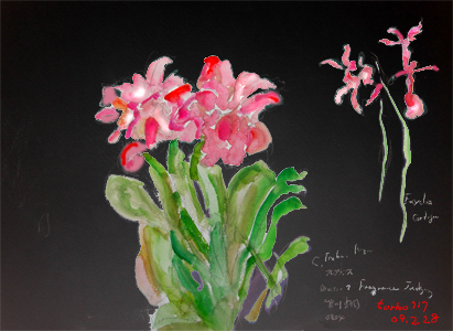
世界らん展日本大賞2009(その2)_story(1511) 2009.2.28 世界らん展日本大賞2009(東京ドーム)に駆けつけた理由は昨日の日記に書いた「100年に一度の大発見!」という日本初おみみえの「フラグミペディウム属コバチー(Phragmipedium kovachii)」を鑑賞するためであったが、この他にもう1つ、岐阜県立恵那農業高校のデスプレイ部門ーオープンクラスへの参加作品を鑑賞するためでもあった。2月上旬にTVに高校の温室から、トラックで苗を運ぶ映像が映っていたからである。<さて、会場の恵那農業高校ブースでは、「谷川が流れ、陽光を浴びたジャングルの湿地」という情景のような感じで癒しの空間を創造していた。何万という壮大な欄の株で10畳ほどがびっしりと覆われ、息を呑むすごさであった。ディスプレイ審査部門で奨励賞を獲得していた。よくぞ、高校生のレベルで、これほどのディスプレイが出来るものだと感心をした。 世界らん展日本大賞2009-香り部門(フレグランス審査部門)Encyclia Cordijeanなど・・・東濃の地から、東京の世界展に打って出るというアクティブな活動に拍手を送りたい。来場者のほぼ全員が足を止め、カメラで記念撮影をしたりと、それはものすごい反響であった。絵は東京ドーム内(0° pm2:00 Google Earth 地名=東京ドーム スケッチpoint =35.705583 ,139.751911 (単位は°)(北緯、東経表示では、35°42'2.01" N,139°45'6.88" E))(Google Earthの検索ウィンドウ(ジャンプ先)に、10進度数、あるいは北緯,東経(E,Nの文字も)を入力(ドラッグしてコピーし貼り付け)しますと、その場所に地球儀が周り拡大表示されます。都心部ではくっきり映りますが、山岳部では、ぼやけます。高度が下がっていくとき、クリックすれば止まります。)
Feb 28, 2009
コメント(1)
-

日本一のラジウム温泉
ローソク温泉へ_story(1431) 2008.12.10日本一を誇る『ラジウムの里』:湯之島ラジウム鉱泉保養所:ローソク温泉恵那峡を越えてローソク温泉までの野山を越えている。もちろんrunningだ。温泉に行くのにrunningとは?帰りは汗びっしょりですが?心配はご無用。もともとこの温泉は、湯治(とうじ)用の温泉で、一切の洗剤は使えないため、家に帰ってから、本格的に頭を洗ったりしなければならない。薬用温泉なのである。マラソンで行っても平気なのである。お風呂では、お湯をすくって身体にお湯をかけて流すなどの、お湯のムダ使いはしてはならない。外にある普通のお湯で身体にさっと流して入るだけの温泉。まさに湯治専用風呂なのである。1回は15分まで。1日 3回までと、かなり厳しい。しかしながら、ここに通いつめて、ぜんそくを治した人や、リューマチを治した人も多く。それがうわさになり、全国からやってくる。源済橋から見た木曽川、付知川・付知方向正面は品の字岩のある付知川の河口。遠くは高峰山「ちんの峠」方向。この源済橋を渡ってローソク温泉へ向かう。絵のような風景が毎回楽しみである。しかしながらこの橋、地元の人しか通らない橋である。さて、runningはまず美しい恵那峡をわたる橋:源済橋を渡る。ここが絶景なのである。足元は、木曽川がたゆたゆと流れ、遊覧船が小さく見える。品の字という岩がある場所で、かつ付知川が合流する場所で旋回し、帰っていく場所である。日本の色、世界の色Japanese-color_world-color(その14)今回は青色系統(69色のその2)330色以上の名前の付いた色からblue_color系統のパターン2。11/27から連載しています。数値はCMYK値スケッチ情報:絵は(30° pm12:53 GPS:Google Earth 地名=中津川 スケッチpoint 35.507069 ,137.446917 (単位は°)(北緯、東経表示では、35°30'25.45" N,137°26'48.9" E))Google Earth(Google Earthの検索ウィンドウ(ジャンプ先)に、10進度数、あるいは北緯,東経(E,Nの文字も)を入力(ドラッグしてコピーし貼り付け)し検索ボタンをクリックしますと、その場所に地球儀が周り拡大表示されます。都心部ではくっきり映りますが、山岳部では、ぼやけます。高度が下がっていくとき、クリックすれば止まります。)都心では、ストリートビューが楽しめます。
Dec 10, 2008
コメント(3)
-

日本ダービーと恵那峡北部山里
二つ森山_付知川右岸_日本ダービー_story(1239) 2008.6.1 最近日記に絵が追いつかなくなっており、話のほうが先行します。
Jun 1, 2008
コメント(4)
-

アフリカ展と恵那峡
TICADと恵那峡_story(1238) 2008.5.31横浜・桜木町の「みなと未来」はアフリカ一色である。ランドマークタワーのホテルではアフリカの大統領などの送迎でものものしい警備。パシフィコ横浜展示ホールBで、6/1まで開催中のアフリカン・フェア2008に行ってきた。愛知万博で触れ合ったあの”アフリカ”に触れたくて自然と体が向かっていた。スーダンのブースでは置物を買った。感動したのは、展示場の一角に置いてあった、地雷爆破ブルドーザ(地雷除去機;Demining Equipment for Anti-Personnel Landmines)である。2台もあって高い運転席に行列をして登っていたことだ。1億1千万個の地雷が70カ国にあるという。これらは50年間は効力があるという。毎年2万5千人が犠牲になる。もともと人を吹き飛ばす目的であるため、ブルートザーであれば安全であろう。掃討作戦で、地面をならしていく。ブルトザーは35トンくらいでありこの重さで自身でも地雷を爆破できる。巨体はふっ飛飛ばない。ショベルの部分に、回転する錘が何百と取り付けられ、それが地雷原を耕していく。センサーで一つ一つ探り出すという方式ではなく、まさに地中浅く埋められた地雷をこなごなに砕き、破片を磁石で引き寄せ、きれに掃除していく。そのようにして安全な原っぱに戻す。置いてあったのは、巨大なブルトーザ型で、前面のショベルの中が特殊な回転鉛。後方が田を耕すような羽がついており、クサリが何重にも垂れているというものものしい機械であった。クレーン型のものなど土地に合わせて1台1台オーダされるようだ。アンゴラには国立地雷除去院という政府機関があり、そこの職員が現在国土にばら撒かれている地雷を除去しているということであった。日立建機(山梨県南アルプス市)のものは6カ国58台が稼動しており、全数現役であるというすぐれもの。源済橋からの恵那峡下流部橋は車が1台しか渡れない。眼下には何十分かに1回 遊覧船が通る。日の差す向こう側からジェット機のようなスピードで迫ってくる。その速さといったら。隠れる暇がないほどだ。朝食時の喧騒・・・昨日に続き、これらの作業と並行して、顔の髭剃り、布団の片付け、朝刊の取り出し、着替え・・・。すべてが8分で済む。絵は(46° am10:16 Google Earth 地名=恵那峡 スケッチpoint 35.507050,137.7450269 (単位は°)(北緯、東経表示では、35°30′25.38" N,137°27'0.97" E))(Google Earthの検索ウィンドウ(ジャンプ先)に、10進度数、あるいは北緯,東経(E,Nの文字も)を入力(ドラッグしてコピーし貼り付け)し検索ボタンをクリックしますと、その場所に地球儀が周り拡大表示されます。都心部ではくっきり映りますが、山岳部では、ぼやけます。高度が下がっていくとき、クリックすれば止まります。)
May 31, 2008
コメント(2)
-

源済橋とバター狂想曲
木曽川_恵那峡_story(1237) 2008.5.30バターがまったく手に入らない。牛乳もあぶないという。酪農家の廃業が続く中で、乳牛の餌代が高騰しており、さらに廃業に拍車をかけているという。しかも、生乳があったとしても、保存期間の短い順に1.牛乳 2.生クリーム 3.チーズ 4.バターへと流れるため、需要に追いつかない。東南アジアの富裕層などに酪農製品の販路を拡大することにより酪農家が安心して生産を続けることができる体制などが必須である。さて、小生もう8年間も自宅で食パンを作っているが、このバターが手に入らないと大変困るのである。イギリスなどではいかがでしょうか?恵那峡-源済橋ネコに案内された東屋(あずまや)からそれ、崖沿いを南下。「源済橋」の由来となった「源済岩(玄済岩)」がある。この岩を回り込んで川を望む場所にでると、柵があり、ここからがまた絶景。戦国時代の武将、吉村源済(吉村玄済ともいう)は、頭脳、腕力に秀でていたという。武田信玄が美濃国攻略を行う際、源済に協力を申し入れたが、源済はそれを断ったため討ち取られた。朝食時の喧騒・・・朝食の準備とパンの準備と炊飯の準備が重なる時は大忙しである。赤の部分が朝食の準備 緑の部分が夜食の準備 青の部分が食パンの準備 茶色の部分が炊飯のセット お湯をたっぷり沸かす(~5分)同時に、冷凍庫からパンを1枚取り出しパン焼器にかける。(~5分)パン焼器に水190ccを注ぐ。強力粉を280g量り入れる。スキムミルクをカップ1杯量り入れる。お湯が沸騰したら、コヒーカップと濾過器を暖める。お湯が、濾過されたら、新に濾過器にコヒーを一杯分入れる。熱湯を少量注ぐ。卵用のフライパンを温める。パンが焼きあがる。マーガリンを塗って、2つに切る。蜂蜜を塗り、ラップで包む(おやつ用にカバンに入れる)朝食用のパンを焼く。炊飯器に米3合、水を入れ、タイマーをかける。砂糖をカップ2杯量り入れる。黄な粉をスプーン1杯カップに入れる。ヨーグルトをスプーン大1カップ分容器に入れる。濾過器に熱湯を100ccほど注ぐ。塩を小カップ1杯量り入れる。卵を割りいれ、お湯を注ぎ蒸し焼きにあする。バターを20g、包丁で切り入れる。カテキン(粉のお茶)をスプーン1杯容器にいれ、蜂蜜と牛乳を混ぜておく。朝食用のパンが焼きあがる。マーガリンを塗る。濾過器に熱湯を50ccほど注ぐ。ベーキングパウダーを小カップ1杯量り入れる。タイマーを7時間にセット。出来立ての卵をパンに載せる。コヒーが出来あがる。すべてを食卓に運び、ジャムを載せてひとかじり。 このバターが今 手に入らないのである。上記朝食の中で、黄な粉とヨーグルト、カテキン+牛乳の食の組み合わせは、どうも体調の維持、腰痛の防止など、大変効果的ではないか思うのである。絵は(46° am10:16 Google Earth 地名=恵那峡 スケッチpoint 35.507050,137.7450269 (単位は°)(北緯、東経表示では、35°30′25.38" N,137°27'0.97" E))(Google Earthの検索ウィンドウ(ジャンプ先)に、10進度数、あるいは北緯,東経(E,Nの文字も)を入力(ドラッグしてコピーし貼り付け)し検索ボタンをクリックしますと、その場所に地球儀が周り拡大表示されます。都心部ではくっきり映りますが、山岳部では、ぼやけます。高度が下がっていくとき、クリックすれば止まります。)
May 30, 2008
コメント(4)
-
四季折々-5月の恵那峡
木曽川_恵那峡_品の字岩_story(1236) 2008.5.29事務所から17分という時間でこの景勝地に立てる。午後3時から雨になるという予報の土曜日、時間を稼ぐために車で向かった。この絶景Pointは、市民にはまだ知られていないようだ。まさに猫一匹だけが迎えに来てくれる。道案内をしてくれる。ニャーニャーと言いながら。恵那峡-最深部鮎つりで有名な付知川の河口。木曽川に合流する。色が混ざり合う場所である。中央下よりに岩が3つあり、丁度「品」の字に見えることから「品の字」岩と呼ばれている。潅木の道を下ると、東屋があり展望台となっている。遊覧船からは、木々に遮られてこの東屋は見えにくいだろう。ドラム缶が丸く弧を描き中で浚渫船が始終なにか作業をしている。ポンプの音がしている。恵那峡遊覧船もこのあたりまでで、赤い美恵大橋が見える場所とも重なり、ここでUターンする。恵那峡の最深部にある品の字岩の場所。付知川が木曽川と合流する場所で、このあたり人家がまったくなく、まさに絶景。絵は(46° am10:16 Google Earth 地名=恵那峡 スケッチpoint 35.507050,137.7450269 (単位は°)(北緯、東経表示では、35°30′25.38" N,137°27'0.97" E))(Google Earthの検索ウィンドウ(ジャンプ先)に、10進度数、あるいは北緯,東経(E,Nの文字も)を入力(ドラッグしてコピーし貼り付け)し検索ボタンをクリックしますと、その場所に地球儀が周り拡大表示されます。都心部ではくっきり映りますが、山岳部では、ぼやけます。高度が下がっていくとき、クリックすれば止まります。)
May 29, 2008
コメント(2)
全8件 (8件中 1-8件目)
1